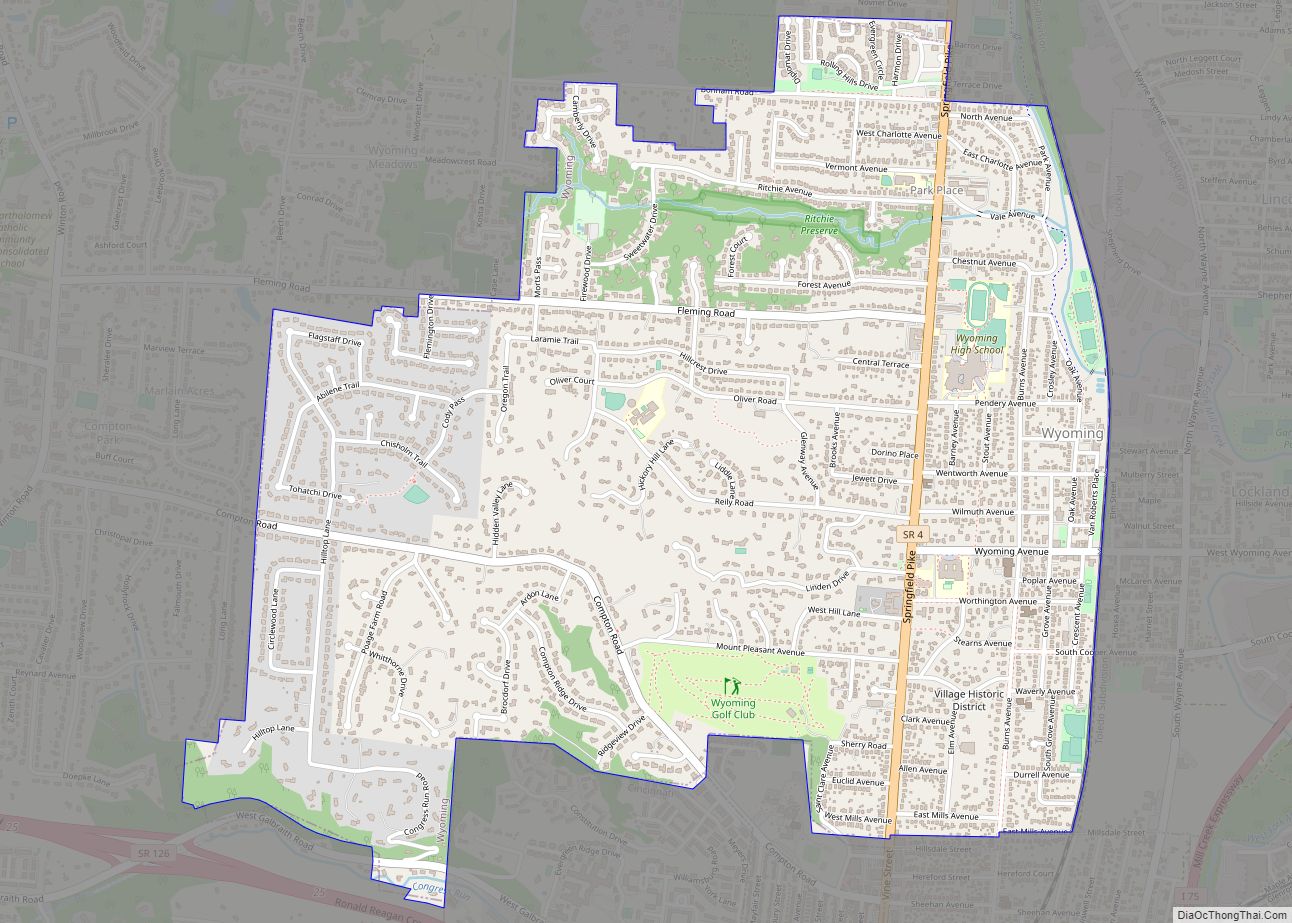
Map of Wren village

Map of Wren village

Wren is a village in Van Wert County, Ohio, United States. The population was 194 at the 2010 census. It is included within the Van Wert, Ohio Micropolitan Statistical Area. Wren village overview: Name: Wren village LSAD Code: 47 LSAD Description: village (suffix) State: Ohio County: Van Wert County Total Area: 0.28 sq mi (0.72 km²) Land Area: … Read more

Map of Worthington city, Ohio

Map of Worthington city, Ohio

Worthington is a city in Franklin County, Ohio, United States, and is a northern suburb of Columbus. The population in the 2020 Census was 14,786. The city was founded in 1803 by the Scioto Company led by James Kilbourne, who was later elected to the United States House of Representatives, and named in honor of … Read more

Map of Wooster city, Ohio

Map of Wooster city, Ohio

Wooster (/ˈwʊstər/ WUUS-tər) is the county seat of Wayne County, Ohio, United States. Located in northeastern Ohio, the city lies approximately 50 mi (80 km) south-southwest of Cleveland, 35 mi (56 km) southwest of Akron and 30 mi (48 km) west of Canton. The population was 27,232 at the 2020 census. It is the largest in Wayne County, and the center … Read more

Map of Woodville village, Ohio

Map of Woodville village, Ohio

Woodville is a village in Sandusky County, Ohio, United States. The population was 2,135 at the 2010 census. The National Arbor Day Foundation has designated Woodville as a Tree City USA. Woodville village overview: Name: Woodville village LSAD Code: 47 LSAD Description: village (suffix) State: Ohio County: Sandusky County Total Area: 1.35 sq mi (3.49 km²) Land Area: … Read more

Map of Woodstock village, Ohio

Map of Woodstock village, Ohio

Woodstock is a village in Champaign County, Ohio, United States. The population was 305 at the 2010 census. Woodstock village overview: Name: Woodstock village LSAD Code: 47 LSAD Description: village (suffix) State: Ohio County: Champaign County Total Area: 0.28 sq mi (0.73 km²) Land Area: 0.28 sq mi (0.73 km²) Water Area: 0.00 sq mi (0.00 km²) Total Population: 287 Population Density: 1,014.13/sq mi (392.23/km²) … Read more

Map of Woodsfield village

Map of Woodsfield village

Woodsfield is a village and the county seat of Monroe County, Ohio, United States, located about 30 miles (48 km) northeast of Marietta. The population was 2,210 at the 2020 census. Woodsfield village overview: Name: Woodsfield village LSAD Code: 47 LSAD Description: village (suffix) State: Ohio County: Monroe County Elevation: 1,204 ft (367 m) Total Area: 2.02 sq mi (5.22 km²) … Read more

Map of Woodmere village, Ohio

Map of Woodmere village, Ohio

Woodmere is a village in Cuyahoga County, Ohio, United States. As of the 2020 census, Woodmere had a population of 641 residents. An eastern suburb of Cleveland, it is part of the Cleveland metropolitan area. Woodmere village overview: Name: Woodmere village LSAD Code: 47 LSAD Description: village (suffix) State: Ohio County: Cuyahoga County Elevation: 1,210 ft … Read more

Map of Yorkshire village, Ohio

Map of Yorkshire village, Ohio

Yorkshire is a village in Darke County, Ohio, United States. The population was 99 at the 2010 census. Yorkshire village overview: Name: Yorkshire village LSAD Code: 47 LSAD Description: village (suffix) State: Ohio County: Darke County Total Area: 0.27 sq mi (0.70 km²) Land Area: 0.27 sq mi (0.70 km²) Water Area: 0.00 sq mi (0.00 km²) Total Population: 95 Population Density: 351.85/sq mi (135.94/km²) … Read more

Map of Yellow Springs village

Map of Yellow Springs village

Yellow Springs is a village in Greene County, Ohio, United States. The population was 3,697 at the 2020 census. It is part of the Dayton Metropolitan Statistical Area. It is home to Antioch College. Yellow Springs village overview: Name: Yellow Springs village LSAD Code: 47 LSAD Description: village (suffix) State: Ohio County: Greene County Total … Read more

Map of Yankee Lake village

Map of Yankee Lake village

Yankee Lake is a village in eastern Trumbull County, Ohio, United States, located along Yankee Run. The population was 75 at the 2020 census. It is part of the Youngstown–Warren metropolitan area. The community is served by the Brookfield, Ohio post office. Yankee Lake village overview: Name: Yankee Lake village LSAD Code: 47 LSAD Description: … Read more

Map of Zoar village

Map of Zoar village, Ohio

Zoar is a village in Tuscarawas County, Ohio, United States. The population was 169 at the 2010 census. The community was founded in 1817 by Radical Pietists as a utopian Christian community, which survived until 1898. Much of the village’s early layout survives, as do many buildings from its utopian origins. Most of the community … Read more

Map of Zanesville city, Ohio

Map of Zanesville city, Ohio

Zanesville is a city in and the county seat of Muskingum County, Ohio, United States. Located at the confluence of the Licking and Muskingum rivers, the city is approximately 52 miles (84 km) east of Columbus and had a population of 24,765 as of the 2020 census, down from 25,487 as of the 2010 census. Historically … Read more