Map of Washington Court House city

Map of Washington Court House city

Washington Court House (often abbreviated as Washington C.H.) is a city in Union Township, Fayette County, Ohio. It is the county seat of Fayette County and is located between Cincinnati and Columbus. The population grew almost 1.5% from 2010 to 2020 approaching 14,401 people according to the 2020 census results. The area was initially settled … Read more

Map of Warsaw village, Ohio

Map of Warsaw village, Ohio

Warsaw is a village in Coshocton County, Ohio, United States, along the Walhonding River. The population was 682 at the 2010 census. Warsaw village overview: Name: Warsaw village LSAD Code: 47 LSAD Description: village (suffix) State: Ohio County: Coshocton County Total Area: 0.50 sq mi (1.30 km²) Land Area: 0.49 sq mi (1.26 km²) Water Area: 0.01 sq mi (0.04 km²) Total Population: 634 … Read more

Map of Warrensville Heights city

Map of Warrensville Heights city

Warrensville Heights is a city located in Cuyahoga County, Ohio, United States. It is an East Side suburb of Cleveland. The population was 13,789 at the 2020 U.S. Census. Warrensville Heights city overview: Name: Warrensville Heights city LSAD Code: 25 LSAD Description: city (suffix) State: Ohio County: Cuyahoga County Incorporated: 1960 Elevation: 1,037 ft (316 m) Total … Read more

Map of Wapakoneta city

Map of Wapakoneta city

Wapakoneta, (/ˌwɔːpəkəˈnɛtə/, local pronunciation: [wɒpəkəˈnɛɾə]) is a city in and the county seat of Auglaize County, Ohio, United States, about 56 miles (90 km) north of Dayton and 83 miles (134 km) south of Toledo. The population was 9,957 at the 2020 census. It is the principal city of and is included in the Wapakoneta, Ohio Micropolitan Area, … Read more

Map of Wayne Lakes village

Map of Wayne Lakes village

Wayne Lakes is a village in Darke County, Ohio, United States. The population was 718 at the 2010 census. Wayne Lakes village overview: Name: Wayne Lakes village LSAD Code: 47 LSAD Description: village (suffix) State: Ohio County: Darke County Total Area: 0.65 sq mi (1.68 km²) Land Area: 0.53 sq mi (1.38 km²) Water Area: 0.12 sq mi (0.30 km²) Total Population: 693 Population … Read more

Map of Waverly village, Ohio

Map of Waverly village, Ohio

Waverly (sometimes known as Waverly City) is a city in, and the county seat of, Pike County, Ohio, United States, located 14 miles south of Chillicothe. The population was 4,165 at the 2020 census. The town was formed in 1829, as the construction of the Ohio and Erie Canal along the west bank of the … Read more

Map of Wauseon city

Map of Wauseon city

Wauseon (/ˈwɔːsiɒn/ WAW-see-on) is a city in and the county seat of Fulton County, Ohio, approximately 31 mi (51 km) west of Toledo. The population was 7,332 at the time of the 2010 census. Wauseon city overview: Name: Wauseon city LSAD Code: 25 LSAD Description: city (suffix) State: Ohio County: Fulton County Elevation: 771 ft (235 m) Total Area: … Read more

Map of Waterville city, Ohio

Map of Waterville city, Ohio

Waterville is a city in Lucas County, Ohio, United States, along the Maumee River, a suburb of Toledo. The population was 6,003 at the 2020 census. Waterville is most well known on the Internet for being the production location for the gaming comedy review series Scott The Woz and the residence of its creator Scott … Read more

Map of Waterford CDP, Ohio

Map of Waterford CDP, Ohio

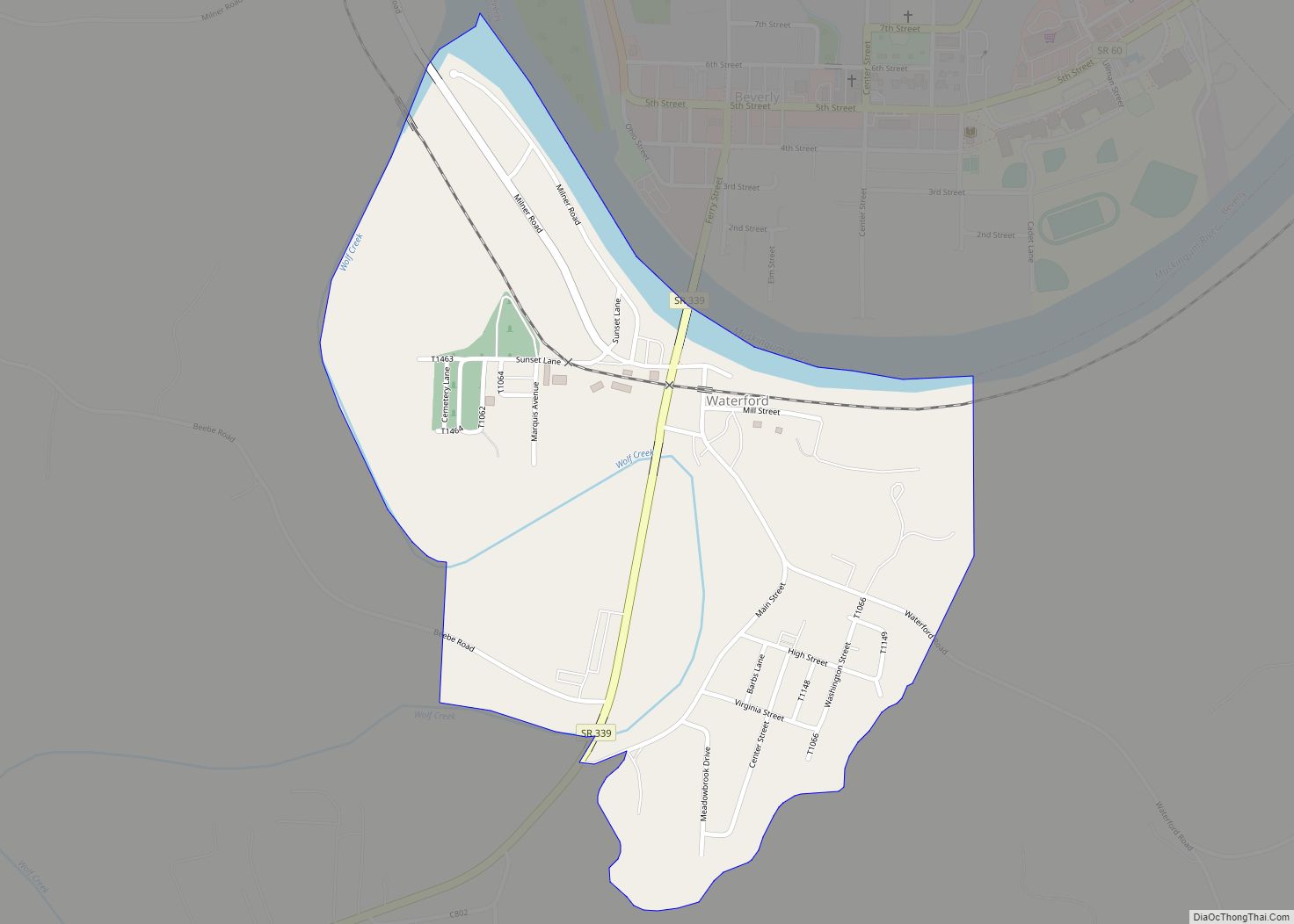
Waterford is a census-designated place in central Waterford Township, Washington County, Ohio, United States. It has a post office with the ZIP code 45786. It is located on State Route 339 across the Muskingum River from the village of Beverly, slightly below where Wolf Creek meets the Muskingum. The community is home to both schools … Read more

Map of West Elkton village

Map of West Elkton village

West Elkton is a village in Preble County, Ohio, United States. The population was 197 at the 2010 census. It is part of the Dayton Metropolitan Statistical Area. West Elkton village overview: Name: West Elkton village LSAD Code: 47 LSAD Description: village (suffix) State: Ohio County: Preble County Total Area: 0.58 sq mi (1.51 km²) Land Area: 0.58 sq mi … Read more

Map of West Carrollton city

Map of West Carrollton city

West Carrollton is a city in Montgomery County, Ohio, United States. A suburb of Dayton, its population was 13,129 at the 2020 census. It is part of the Dayton Metropolitan Statistical Area. The Great Miami River runs through the town and forms most of its northern border. West Carrollton city overview: Name: West Carrollton city … Read more

Map of West Alexandria village

Map of West Alexandria village

West Alexandria is a village in Preble County, Ohio, United States. The population was 1,340 at the 2010 census. West Alexandria village overview: Name: West Alexandria village LSAD Code: 47 LSAD Description: village (suffix) State: Ohio County: Preble County Total Area: 0.86 sq mi (2.24 km²) Land Area: 0.86 sq mi (2.24 km²) Water Area: 0.00 sq mi (0.00 km²) Total Population: 1,334 Population … Read more