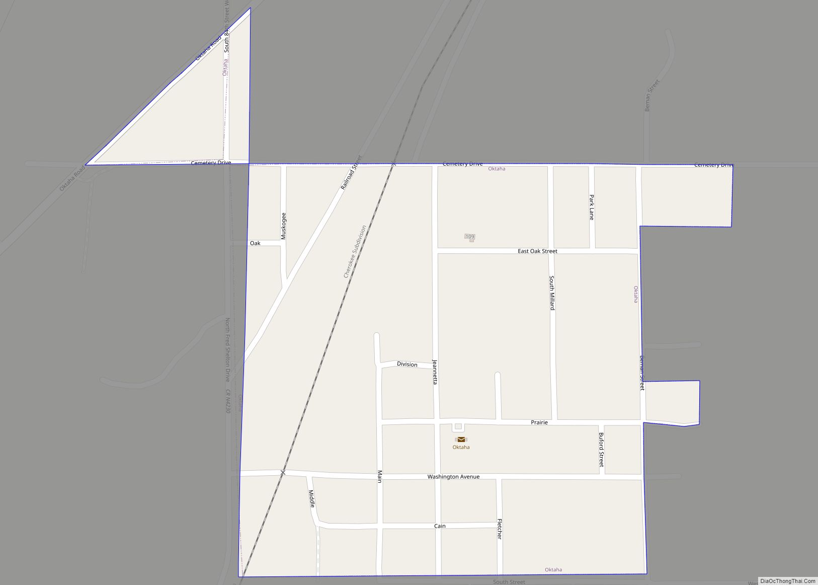
Map of Oologah town

Map of Oologah town

Oologah is a town in Rogers County, Oklahoma, United States. The renowned humorist Will Rogers was born on a ranch two miles east of Oologah, although he usually claimed Claremore as his birthplace “because nobody but an Indian can pronounce ‘Oologah.’” There has been disagreement about the proper spelling for the town name, but, nowadays, … Read more

Map of Olustee town

Map of Olustee town

Olustee is a town in Jackson County, Oklahoma, United States. “Olustee” is said to be a Seminole word meaning “pond” or from the Creek (Muscogee) language ue-lvste (/oy-lást-i/) meaning “black water”, and being taken from the Battle of Olustee in Florida. The population was 607 at the 2010 census. Olustee town overview: Name: Olustee town … Read more

Map of Old Green CDP

Map of Old Green CDP

Old Green is a census-designated place (CDP) in Adair County, Oklahoma, United States. The population was 315 at the 2010 census. Old Green CDP overview: Name: Old Green CDP LSAD Code: 57 LSAD Description: CDP (suffix) State: Oklahoma County: Adair County Elevation: 1,093 ft (333 m) Total Area: 3.16 sq mi (8.18 km²) Land Area: 3.14 sq mi (8.14 km²) Water Area: 0.02 sq mi … Read more

Map of Old Eucha CDP

Map of Old Eucha CDP

Old Eucha is a census-designated place (CDP) in Delaware County, Oklahoma, United States. The population was 52 at the 2010 census. Old Eucha CDP overview: Name: Old Eucha CDP LSAD Code: 57 LSAD Description: CDP (suffix) State: Oklahoma County: Delaware County Elevation: 940 ft (290 m) Total Area: 3.10 sq mi (8.03 km²) Land Area: 3.10 sq mi (8.03 km²) Water Area: 0.00 sq mi … Read more

Map of Pawhuska city

Map of Pawhuska city

Pawhuska (Osage: , hpahúska, lit.: White Hair; Chiwere: Paháhga) is a city in and the county seat of Osage County, Oklahoma, United States. It was named after the 19th-century Osage chief, Paw-Hiu-Skah, which means “White Hair” in English. The Osage tribal government, which opened offices in Pawhuska in 1872 when its reservation was established in … Read more

Map of Pauls Valley city

Map of Pauls Valley city

Pauls Valley is a city in and the county seat of Garvin County, Oklahoma, United States. The population was 5,992 at the 2020 census, a decline of 3.2 percent from the figure of 6,187 in 2010. It was settled by and named for Smith Paul, a North Carolina native who married a Chickasaw woman and … Read more

Map of Park Hill CDP

Map of Park Hill CDP

Park Hill is an unincorporated community and census-designated place (CDP) in southwestern Cherokee County, Oklahoma, United States. The population was 3,909 at the 2010 census. It lies near Tahlequah, east of the junction of U.S. Route 62 and State Highway 82. Founded in 1838, Park Hill became the home of many important Cherokee leaders, including … Read more

Map of Paradise Hill town

Map of Paradise Hill town

Paradise Hill is a town in the northwest corner of Sequoyah County, Oklahoma, United States. It is part of the Fort Smith, Arkansas-Oklahoma Metropolitan Statistical Area. The population was 85 at the 2010 census, a decline from the figure of 100 recorded in 2000. Paradise Hill town overview: Name: Paradise Hill town LSAD Code: 43 … Read more

Map of Paoli town, Oklahoma

Map of Paoli town, Oklahoma

Paoli (/peɪˈoʊlʌ/ pay-OH-luh) is a town in Garvin County, Oklahoma, United States. The population was 610 at the 2010 census. It was named after Paoli, Pennsylvania, an unincorporated community near Philadelphia from which many of the railroad workers who built the town came. Paoli town overview: Name: Paoli town LSAD Code: 43 LSAD Description: town … Read more

Map of Panola CDP, Oklahoma

Map of Panola CDP, Oklahoma

Panola CDP overview: Name: Panola CDP LSAD Code: 57 LSAD Description: CDP (suffix) State: Oklahoma FIPS code: 4056950 Online Interactive Map Panola online map. Source: Basemap layers from Google Map, Open Street Map (OSM), Arcgisonline, Wmflabs. Boundary Data from Database of Global Administrative Areas. Panola location map. Where is Panola CDP? Panola Road Map Panola … Read more

Map of Panama town, Oklahoma

Map of Panama town, Oklahoma

Panama is a town in Le Flore County, Oklahoma, United States. It is part of the Fort Smith, Arkansas-Oklahoma Metropolitan Statistical Area. The population was 1,413 at the 2010 census. Panama town overview: Name: Panama town LSAD Code: 43 LSAD Description: town (suffix) State: Oklahoma County: Le Flore County Elevation: 453 ft (138 m) Total Area: 2.28 sq mi … Read more

Map of Paden town, Oklahoma

Map of Paden town, Oklahoma

Paden is a town in Okfuskee County, Oklahoma, United States. The population was 461 at the 2010 census. It is named for Paden Tolbert, a U.S. Deputy Marshal who served the area in the early 1900s. Paden town overview: Name: Paden town LSAD Code: 43 LSAD Description: town (suffix) State: Oklahoma County: Okfuskee County Elevation: … Read more