Map of Gates city, Oregon
Gates is a city on the border of Linn and Marion counties in Oregon, United States. The population was 548 at the 2020 census. The greater part of Gates’ population is in Marion County and the city is primarily under Marion County’s jurisdiction. The Marion County portion of Gates is part of the Salem Metropolitan ... Read more
Map of Gates city, Oregon
Map of Gaston city, Oregon
Gaston is a city in Washington County, Oregon, United States. Located between Forest Grove to the north and Yamhill to the south, the city straddles Oregon Route 47 and borders the Tualatin River. Named after railroad executive Joseph Gaston, its population was 637 as of the 2010 census. Gaston city overview: Name: Gaston city LSAD ... Read more
Map of Gaston city, Oregon
Map of Garibaldi city
Garibaldi (/ˌɡærɪˈbɔːldi/ GARR-ib-AWL-dee) is a city in Tillamook County, in the U.S. state of Oregon. The population was 830 at the 2020 census. Garibaldi city overview: Name: Garibaldi city LSAD Code: 25 LSAD Description: city (suffix) State: Oregon County: Tillamook County Incorporated: 1946 Elevation: 22 ft (6.7 m) Total Area: 1.37 sq mi (3.54 km²) Land Area: 0.99 sq mi (2.55 km²) Water ... Read more
Map of Garibaldi city
Map of Gardiner CDP, Oregon
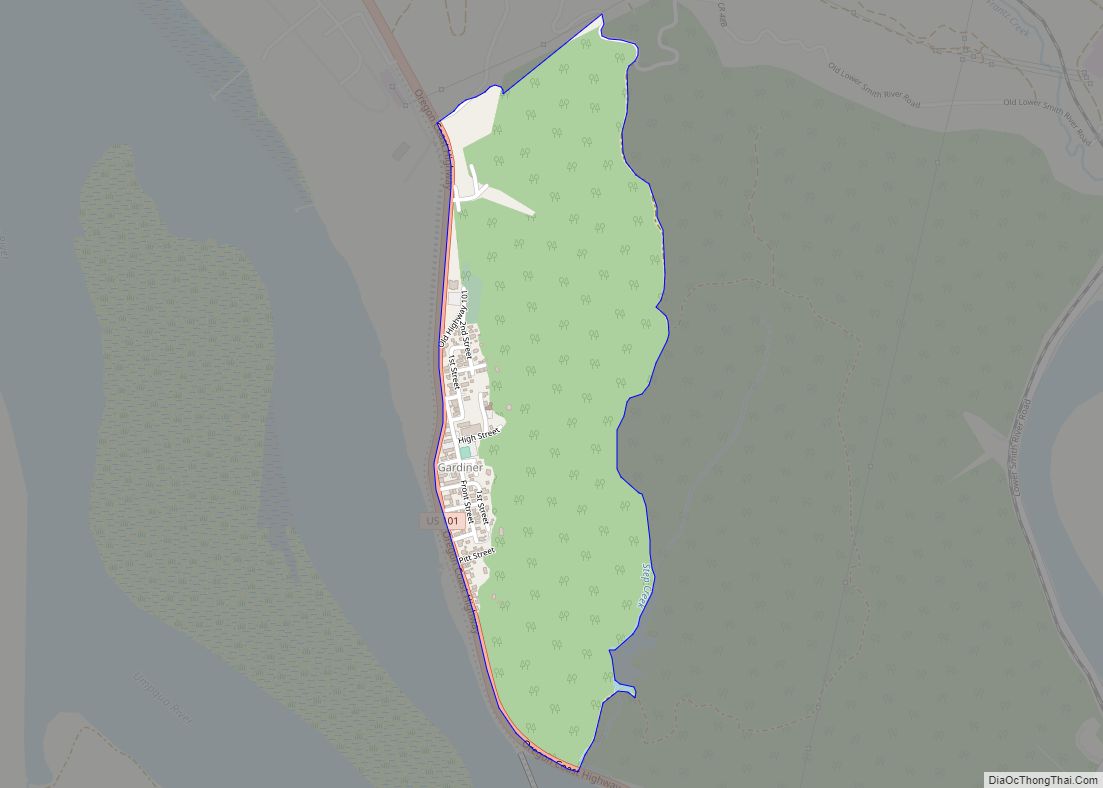
Gardiner is an unincorporated community and census-designated place in Douglas County, Oregon, United States, across the Umpqua River from Reedsport. It is located on U.S. Route 101. As of the 2010 census, it had a population of 248. Gardiner is named for a Boston merchant whose ship, the Bostonian, shipwrecked at the mouth of the ... Read more
Map of Gardiner CDP, Oregon
Map of Granite city, Oregon
Granite is a city in Grant County, in the U.S. state of Oregon. The city had a population of 38 in 2010, up from 24 in 2000. In 2010, it was the fourth-smallest incorporated city by population in Oregon. The smaller cities were Shaniko (36 people), Lonerock (21), and nearby Greenhorn (0). Granite city overview: ... Read more
Map of Granite city, Oregon
Map of Grand Ronde CDP
Grand Ronde is a census-designated place (CDP) and unincorporated community in Polk and Yamhill counties, Oregon, United States. Historically noted as a village in Polk County, the sphere of influence and community is in both Polk and Yamhill counties. The name of the community is a variation of the French Grande Ronde or “Grand Round” ... Read more
Map of Grand Ronde CDP
Map of Government Camp CDP
Government Camp is an unincorporated community and census-designated place located in Clackamas County, Oregon, United States, on the base of Mount Hood and north of Tom Dick and Harry Mountain. It is the only town within 5 miles (8 km) of Mount Hood and therefore is the de facto “mountain town” or “ski town”. It is ... Read more
Map of Government Camp CDP
Map of Gopher Flats CDP
Gopher Flats is a census-designated place (CDP) in Umatilla County, Oregon, United States. The population was 401 at the 2000 census. It is part of the Pendleton–Hermiston Micropolitan Statistical Area. Gopher Flats CDP overview: Name: Gopher Flats CDP LSAD Code: 57 LSAD Description: CDP (suffix) State: Oregon County: Umatilla County Elevation: 1,217 ft (371 m) Total Area: ... Read more
Map of Gopher Flats CDP
Map of Gold Hill city, Oregon
Gold Hill is a city in Jackson County, Oregon, in the United States. As of the 2010 census the population was 1,335. It is along a bend of the Rogue River. Gold Hill city overview: Name: Gold Hill city LSAD Code: 25 LSAD Description: city (suffix) State: Oregon County: Jackson County Incorporated: 1895 Elevation: 1,085 ft ... Read more
Map of Gold Hill city, Oregon
Map of Gold Beach city
Gold Beach (Tolowa: yan-shu’-chit, yan-shuu-chit’-dvn) is a city in and the county seat of Curry County, Oregon, United States, on the Oregon Coast. The population was 2,241 at the 2020 census. Gold Beach city overview: Name: Gold Beach city LSAD Code: 25 LSAD Description: city (suffix) State: Oregon County: Curry County Incorporated: 1853 Elevation: 23 ft ... Read more
Map of Gold Beach city
Map of Glide CDP
Glide is a census-designated place (CDP) in Douglas County, Oregon, United States. The population was 1,795 at the 2010 census. Glide CDP overview: Name: Glide CDP LSAD Code: 57 LSAD Description: CDP (suffix) State: Oregon County: Douglas County Elevation: 689 ft (210 m) Total Area: 10.16 sq mi (26.31 km²) Land Area: 10.08 sq mi (26.11 km²) Water Area: 0.07 sq mi (0.20 km²) Total Population: ... Read more
Map of Glide CDP
Map of Glendale city, Oregon
Glendale is a city in Douglas County, Oregon, United States. The population was 874 at the 2010 census. Glendale city overview: Name: Glendale city LSAD Code: 25 LSAD Description: city (suffix) State: Oregon County: Douglas County Incorporated: 1901 Elevation: 1,431 ft (436 m) Total Area: 0.39 sq mi (1.02 km²) Land Area: 0.39 sq mi (1.02 km²) Water Area: 0.00 sq mi (0.00 km²) Total Population: ... Read more
Map of Glendale city, Oregon