Map of Huntington city, Oregon
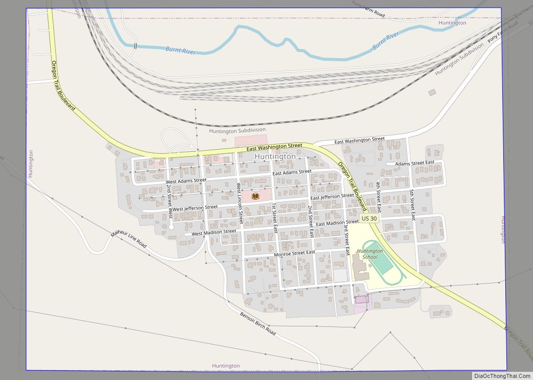
Huntington is a city in Baker County, on the eastern border of Oregon, United States. It is located on the Snake River and along Interstate 84 and U.S. Route 30. The population was 440 at the 2010 census, down from 515 in 2000. Huntington city overview: Name: Huntington city LSAD Code: 25 LSAD Description: city ... Read more
Map of Huntington city, Oregon
Map of Hubbard city, Oregon
Hubbard is a city in Marion County, Oregon, United States. The population was 3,426 at the 2020 census. It is part of the Salem Metropolitan Statistical Area. Hubbard city overview: Name: Hubbard city LSAD Code: 25 LSAD Description: city (suffix) State: Oregon County: Marion County Incorporated: 1891 Elevation: 181 ft (55 m) Total Area: 0.80 sq mi (2.08 km²) Land ... Read more
Map of Hubbard city, Oregon
Map of Hood River city
The city of Hood River is the seat of Hood River County, Oregon, United States. It is a port on the Columbia River, and is named for the nearby Hood River. As of the 2020 census, the city population was 8,313. It is the only city in Oregon where public consumption of alcohol on sidewalks ... Read more
Map of Hood River city
Map of Holley CDP, Oregon
Holley is a census-designated place and unincorporated community in Linn County, Oregon, United States. As of the 2010 census it had a population of 378. It is about 4 miles (6 km) southwest of Sweet Home on Oregon Route 228 near the Calapooia River. The Holley area was once the source of the semi-precious gemstone Holley ... Read more
Map of Holley CDP, Oregon
Map of Hines city
Hines is a city in Harney County, Oregon, United States. The population was 1,563 at the 2010 census. Hines city overview: Name: Hines city LSAD Code: 25 LSAD Description: city (suffix) State: Oregon County: Harney County Incorporated: 1930 Elevation: 4,155 ft (1,266 m) Total Area: 2.11 sq mi (5.48 km²) Land Area: 2.06 sq mi (5.34 km²) Water Area: 0.05 sq mi (0.13 km²) Total Population: ... Read more
Map of Hines city
Map of Hermiston city
Hermiston (/ˈhɜːrməstən/) is a city in Umatilla County, Oregon, United States. Its population of 19,973 makes it the largest city in Eastern Oregon. Hermiston is the largest and fastest-growing, city in the Hermiston-Pendleton Micropolitan Statistical Area, the eighth largest Core Based Statistical Area in Oregon with a combined population of 92,261 at the 2020 census. ... Read more
Map of Hermiston city
Map of Heppner city
Heppner is a city in, and the county seat of, Morrow County, Oregon, United States. As of 2010, the population was 1,291. Heppner is part of the Pendleton-Hermiston Micropolitan Area. Heppner is named after Henry Heppner, a prominent Jewish-American businessman. Heppner city overview: Name: Heppner city LSAD Code: 25 LSAD Description: city (suffix) State: Oregon ... Read more
Map of Heppner city
Map of Helix city
Helix is a city in Umatilla County, Oregon, United States. The population was 184 at the 2010 census. It is part of the Pendleton–Hermiston Micropolitan Statistical Area. Helix city overview: Name: Helix city LSAD Code: 25 LSAD Description: city (suffix) State: Oregon County: Umatilla County Incorporated: 1903 Elevation: 1,754 ft (535 m) Total Area: 0.13 sq mi (0.33 km²) Land ... Read more
Map of Helix city
Map of Hebo CDP
Hebo is an unincorporated community in Tillamook County, Oregon, United States. For statistical purposes, the United States Census Bureau has defined Hebo as a census-designated place (CDP). The census definition of the area may not precisely correspond to local understanding of the area with the same name. The population of the CDP was 231 at ... Read more
Map of Hebo CDP
Map of Hayesville CDP, Oregon
Hayesville is a census-designated place and unincorporated community in Marion County, Oregon, United States, just outside the city limits of Salem but within the city’s urban growth boundary. It is part of the Salem Metropolitan Statistical Area. For statistical purposes, the United States Census Bureau has defined Hayesville as a census-designated place (CDP). The census ... Read more
Map of Hayesville CDP, Oregon
Map of Idaville CDP, Oregon
Idaville is a census-designated place and unincorporated community in Tillamook County, Oregon, United States. It was founded around the year 1870 by Warren N. Vaughn and named for his daughter Ida. The post office was established in 1922 and closed five years later, in 1927. Idaville CDP overview: Name: Idaville CDP LSAD Code: 57 LSAD ... Read more
Map of Idaville CDP, Oregon
Map of Idanha city
Idanha /ɪˈdænə/ is a city on the Marion County/Linn County line in Oregon, United States, on Oregon Route 22 and the Santiam River. The population was 156 at the 2020 census. The Marion County portion of Idanha is part of the Salem Metropolitan Statistical Area, while the Linn County portion is part of the Albany–Lebanon ... Read more
Map of Idanha city