Map of Independence city, Oregon

Map of Independence city, Oregon

Independence is a city in Polk County, Oregon, United States, on the west bank of the Willamette River along Oregon Route 51, and east of nearby Monmouth. It is part of the Salem Metropolitan Statistical Area. Thirty square blocks of the oldest part of Independence form the National Register of Historic Places-listed Independence Historic District. … Read more

Map of Imbler city

Map of Imbler city

Imbler is a city in Union County, Oregon, United States. The population was 306 at the 2010 census. Imbler city overview: Name: Imbler city LSAD Code: 25 LSAD Description: city (suffix) State: Oregon County: Union County Incorporated: 1922 Elevation: 2,725 ft (831 m) Total Area: 0.22 sq mi (0.56 km²) Land Area: 0.22 sq mi (0.56 km²) Water Area: 0.00 sq mi (0.00 km²) Total Population: … Read more

Map of Idaville CDP, Oregon

Map of Idaville CDP, Oregon

Idaville is a census-designated place and unincorporated community in Tillamook County, Oregon, United States. It was founded around the year 1870 by Warren N. Vaughn and named for his daughter Ida. The post office was established in 1922 and closed five years later, in 1927. Idaville CDP overview: Name: Idaville CDP LSAD Code: 57 LSAD … Read more

Map of Idanha city

Map of Idanha city

Idanha /ɪˈdænə/ is a city on the Marion County/Linn County line in Oregon, United States, on Oregon Route 22 and the Santiam River. The population was 156 at the 2020 census. The Marion County portion of Idanha is part of the Salem Metropolitan Statistical Area, while the Linn County portion is part of the Albany–Lebanon … Read more

Map of Jefferson city, Oregon

Map of Jefferson city, Oregon

Jefferson is a city in Marion County, Oregon, United States. It is part of the Salem Metropolitan Statistical Area. The population was 3,327 at the 2020 census. It is home to the annual Mint Harvest Festival and is the self-proclaimed “Mint Capital of the World” as well as “Frog Jumping Capital of Oregon.” The city … Read more

Map of Jeffers Gardens CDP

Map of Jeffers Gardens CDP

Jeffers Garden is an unincorporated community in Clatsop County, Oregon, United States. Its population, recorded as the Jeffers Gardens census-designated place, was 368 as of the 2010 census. Jeffers Gardens CDP overview: Name: Jeffers Gardens CDP LSAD Code: 57 LSAD Description: CDP (suffix) State: Oregon County: Clatsop County Elevation: 3 ft (1 m) Total Area: 0.565 sq mi (1.46 km²) … Read more

Map of Jacksonville city, Oregon

Map of Jacksonville city, Oregon

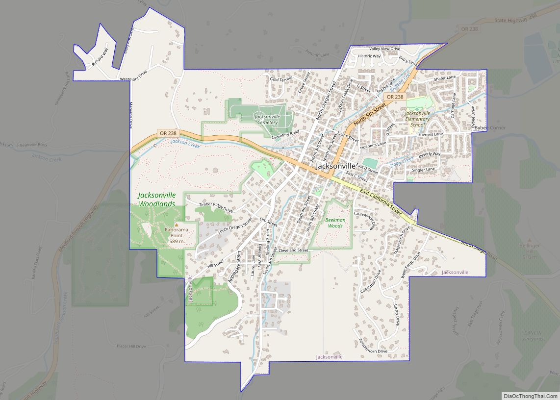
Jacksonville is a city in Jackson County, Oregon, United States, approximately 5 miles (8 km) west of Medford. It was named for Jackson Creek, which flows through the community and was the site of one of the first placer gold claims in the area. It includes Jacksonville Historic District, which was designated a U.S. National Historic … Read more

Map of Island City city

Map of Island City

Island City is a city in Union County, Oregon, United States. Its name originated from the city’s location on an island between the Grande Ronde River and a nearby slough. However, the slough was later diverted, removing the city’s island status. The population was 989 at the 2010 census. Island City overview: Name: Island City … Read more

Map of King City, Oregon

Map of King City, Oregon

King City is a city in Washington County, Oregon, United States. Its name was picked arbitrarily by the Tualatin Development Company, Inc., which used a royalty theme in naming the city streets. The population was 3,111 at the 2010 census. Fire protection and EMS services are provided through Tualatin Valley Fire and Rescue. King City … Read more

Map of Kerby CDP

Map of Kerby CDP

Kerby is an unincorporated community and census-designated place (CDP) in Josephine County, Oregon, United States, north of Cave Junction on U.S. Route 199. As of the 2010 census the population was 595. Despite its population and numerous businesses, it is often listed in tourist guides as a ghost town, because of the number of historic … Read more

Map of Keizer city

Map of Keizer city

Keizer (/ˈkaɪzər/) is a city located in Marion County, Oregon, United States, along the 45th parallel. As of the 2020 United States Census, its population was 39,376. It lies in the Willamette Valley, and is part of the Salem Metropolitan Statistical Area. It was named after pioneer Thomas Dove (T. D.) Keizur and his family, … Read more

Map of Juntura CDP

Map of Juntura CDP

Juntura is an unincorporated community in Malheur County, Oregon, United States on U.S. Route 20. The word juntura is Spanish for “juncture”, and the community was named for its proximity to the confluence of the Malheur River with the North Fork Malheur River. The name was probably selected by local settler B. L. Milligan, who … Read more