Map of Trail CDP, Oregon

Map of Trail CDP, Oregon

Trail is a census-designated place and unincorporated community in Jackson County, Oregon, United States. As of the 2010 census it had a population of 702. It has a post office with a ZIP code of 97541. Trail lies at the intersection of Oregon Route 227 and Oregon Route 62, just north of Shady Cove and … Read more

Map of Toledo city, Oregon

Map of Toledo city, Oregon

Toledo is a city located on the Yaquina River and along U.S. Route 20 in Lincoln County, in the U.S. state of Oregon. The population was 3,465 at the 2010 census. The city was a 2009 All-America City Award finalist. Toledo city overview: Name: Toledo city LSAD Code: 25 LSAD Description: city (suffix) State: Oregon … Read more

Map of Tillamook city

Map of Tillamook city

The city of Tillamook /ˈtɪləmʊk/ is the county seat of Tillamook County, Oregon, United States. The city is located on the southeast end of Tillamook Bay on the Pacific Ocean. The population was 5,231 at the 2020 census. Tillamook city overview: Name: Tillamook city LSAD Code: 25 LSAD Description: city (suffix) State: Oregon County: Tillamook … Read more

Map of Tigard city

Map of Tigard city

Tigard (/ˈtaɪɡərd/ TY-gərd) is a city in Washington County, Oregon, United States. The population was 54,539 at the 2020 census. As of 2007, Tigard was the state’s 12th largest city. Incorporated in 1961, the city is located south of Beaverton and north of Tualatin, and is part of the Portland metropolitan area. Interstate 5 and … Read more

Map of Three Rivers CDP, Oregon

Map of Three Rivers CDP, Oregon

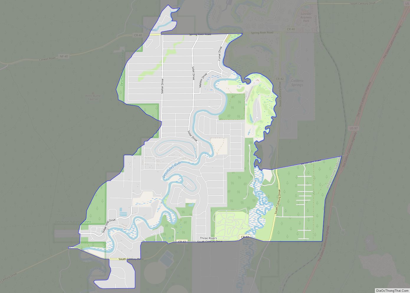
Three Rivers South is a census-designated place (CDP) and unincorporated community in Deschutes County, Oregon, United States. It is part of the Bend, Oregon Metropolitan Statistical Area. The population was 3,014 at the 2010 census. Three Rivers CDP overview: Name: Three Rivers CDP LSAD Code: 57 LSAD Description: CDP (suffix) State: Oregon County: Deschutes County … Read more

Map of The Dalles city

Map of The Dalles city

The Dalles /ˈdælz/, formally City of The Dalles, also called Dalles City, is an inland port and the largest city of Wasco County, Oregon, United States. The population was 16,010 at the 2020 census, and it is the largest city in Oregon along the Columbia River outside the Portland Metropolitan Area. The Dalles is 75 … Read more

Map of Tetherow CDP

Map of Tetherow CDP

Tetherow is a census-designated place (CDP) in Deschutes County, Oregon, United States. It is part of the Bend, Oregon Metropolitan Statistical Area. The population was 45 at the 2010 census. Tetherow CDP overview: Name: Tetherow CDP LSAD Code: 57 LSAD Description: CDP (suffix) State: Oregon County: Deschutes County Elevation: 3,790 ft (1,160 m) Total Area: 2.13 sq mi (5.53 km²) … Read more

Map of Terrebonne CDP

Map of Terrebonne CDP

Terrebonne is an unincorporated community and census-designated place (CDP) in Deschutes County, Oregon, United States. It is part of the Bend, Oregon Metropolitan Statistical Area. The population was 1,257 at the 2010 census. Terrebonne CDP overview: Name: Terrebonne CDP LSAD Code: 57 LSAD Description: CDP (suffix) State: Oregon County: Deschutes County Elevation: 2,871 ft (875 m) Total … Read more

Map of Tangent city

Map of Tangent city

Tangent is a city in Linn County, Oregon, United States. The population was 1,231 at the 2020 census. Tangent was the site of a railway station on the Southern Pacific line south of Albany. Its name referred to a straight stretch of the line with no curves for more than 20 miles (32 km). The federal … Read more

Map of Talent city

Map of Talent city

Talent is a city in Jackson County, Oregon, United States. The population was 6,282 at the 2020 census. Talent city overview: Name: Talent city LSAD Code: 25 LSAD Description: city (suffix) State: Oregon County: Jackson County Incorporated: 1910 Elevation: 1,635 ft (498 m) Total Area: 1.33 sq mi (3.44 km²) Land Area: 1.33 sq mi (3.44 km²) Water Area: 0.00 sq mi (0.00 km²) Total Population: … Read more

Map of Turner city, Oregon

Map of Turner city, Oregon

Turner is a city in Marion County, Oregon, United States. The population was 2,454 at the 2020 census. It is part of the Salem Metropolitan Statistical Area. The community was incorporated by the Oregon Legislative Assembly on February 10, 1905. Since 1971, it is the location of the Enchanted Forest amusement park. Turner city overview: … Read more

Map of Tumalo CDP

Map of Tumalo CDP

Tumalo (/ˈtʌməloʊ/ TUM-ə-loh) is an unincorporated community and census-designated place (CDP) in Deschutes County, Oregon, United States. As of the 2010 census it had a population of 488. In the Klamath language, tumolo means “wild plum,” a plentiful shrub in south central Oregon. Tumola means “ground fog,” which may have described Tumalo Creek. Tumallowa, the … Read more