Map of Beavercreek CDP, Oregon

Map of Beavercreek CDP, Oregon

Beavercreek is an unincorporated hamlet and census-designated place in Clackamas County, Oregon, United States, located 6 miles (10 km) southeast of Oregon City. The population was 4,485 at the 2010 census. Beavercreek CDP overview: Name: Beavercreek CDP LSAD Code: 57 LSAD Description: CDP (suffix) State: Oregon County: Clackamas County Total Area: 20.11 sq mi (52.10 km²) Land Area: 20.10 sq mi … Read more

Map of Beaver CDP, Oregon

Map of Beaver CDP, Oregon

Beaver is an unincorporated community in Tillamook County, Oregon, United States, along U.S. Route 101 and the Nestucca River, about 12 miles (19 km) south of Tillamook. For statistical purposes, the United States Census Bureau has defined Beaver as a census-designated place (CDP). The census definition of the area may not precisely correspond to local understanding … Read more

Map of Beatty CDP, Oregon

Map of Beatty CDP, Oregon

Beatty CDP overview: Name: Beatty CDP LSAD Code: 57 LSAD Description: CDP (suffix) State: Oregon FIPS code: 4105150 Online Interactive Map Beatty online map. Source: Basemap layers from Google Map, Open Street Map (OSM), Arcgisonline, Wmflabs. Boundary Data from Database of Global Administrative Areas. Beatty location map. Where is Beatty CDP? Beatty Road Map Beatty … Read more

Map of Bayside Gardens CDP

Map of Bayside Gardens CDP

Bayside Gardens is an unincorporated community in Tillamook County, Oregon, United States. It lies along Route 101 between Manzanita and Nehalem and borders Nehalem Bay. For statistical purposes, the United States Census Bureau has defined Bayside Gardens as a census-designated place (CDP). The census definition of the area may not precisely correspond to local understanding … Read more

Map of Bay City, Oregon

Map of Bay City, Oregon

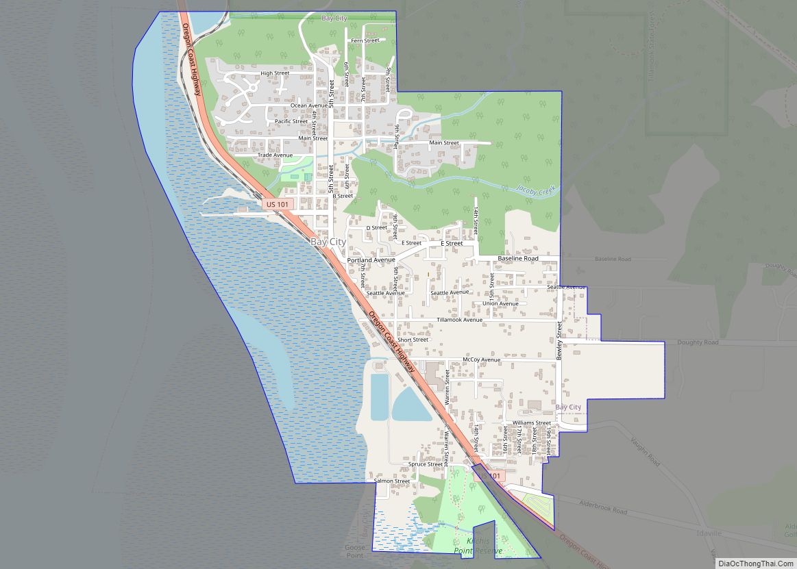
Bay City is a city in Tillamook County, Oregon, United States. The population was 1,286 at the 2010 census. Bay City overview: Name: Bay City LSAD Code: 25 LSAD Description: city (suffix) State: Oregon County: Tillamook County Incorporated: 1910 Elevation: 17 ft (5.18 m) Total Area: 1.62 sq mi (4.19 km²) Land Area: 1.26 sq mi (3.27 km²) Water Area: 0.35 sq mi (0.92 km²) Total … Read more

Map of Barview CDP

Map of Barview CDP

Barview is a census-designated place (CDP) in Coos County, Oregon, United States. The population was 1,844 at the 2010 census. Barview CDP overview: Name: Barview CDP LSAD Code: 57 LSAD Description: CDP (suffix) State: Oregon County: Coos County Elevation: 69 ft (21 m) Total Area: 1.79 sq mi (4.64 km²) Land Area: 1.38 sq mi (3.58 km²) Water Area: 0.41 sq mi (1.06 km²) Total Population: … Read more

Map of Barlow city, Oregon

Map of Barlow city, Oregon

Barlow is a city in Clackamas County, Oregon, United States. The population was 133 at the 2020 census. The mayor of Barlow is Michael Lundsten, as of the most recent election in 2018. Barlow city overview: Name: Barlow city LSAD Code: 25 LSAD Description: city (suffix) State: Oregon County: Clackamas County Incorporated: 1903 Elevation: 101 ft … Read more

Map of Banks city, Oregon

Map of Banks city, Oregon

Banks is a city in Washington County, Oregon, United States which is located in the Tualatin Valley. It is the southern anchor to the Banks–Vernonia State Trail, which is a 21-mile (34 km) long linear trail popular with bicyclists, hikers, and equestrians. The population was 1,777 at the 2010 census. The community was named for John … Read more

Map of Bellfountain CDP

Map of Bellfountain CDP

Bellfountain is a census-designated place and unincorporated community in Benton County, Oregon, United States. Bellfountain lies on Bellfountain Road north of Alpine and northwest of Monroe. The population was 75 at the 2010 census. Bellfountain CDP overview: Name: Bellfountain CDP LSAD Code: 57 LSAD Description: CDP (suffix) State: Oregon County: Benton County Elevation: 331 ft (101 m) … Read more

Map of Beaverton city, Oregon

Map of Beaverton city, Oregon

Beaverton is a city in Washington County, in the U.S. state of Oregon with a small portion bordering Portland in the Tualatin Valley. The city is among the main cities that make up the Portland metropolitan area. Its population was 97,494 at the 2020 census, making it the second-largest city in the county and the … Read more

Map of Brooks CDP, Oregon

Map of Brooks CDP, Oregon

Brooks is an unincorporated community in Marion County, Oregon, United States. For statistical purposes, the United States Census Bureau has defined Brooks as a census-designated place (CDP). The census definition of the area may not precisely correspond to local understanding of the area with the same name. As of the 2020 census the population was … Read more

Map of Brookings city

Map of Brookings city, Oregon

Brookings is a city in Curry County, Oregon, United States. It was named after John E. Brookings, president of the Brookings Lumber and Box Company, which founded the city in 1908. As of the 2020 census, the population was 6,744. Brookings city overview: Name: Brookings city LSAD Code: 25 LSAD Description: city (suffix) State: Oregon … Read more