Beaverton is a city in Washington County, in the U.S. state of Oregon with a small portion bordering Portland in the Tualatin Valley. The city is among the main cities that make up the Portland metropolitan area. Its population was 97,494 at the 2020 census, making it the second-largest city in the county and the seventh-largest city in Oregon. Beaverton is an economic center for Washington County along with neighboring Hillsboro. It is home to the world headquarters of Nike, Inc., although it sits outside of city limits on unincorporated county land.
The hunter–gatherer Atfalati tribe of the Kalapuya people inhabited the Tualatin Valley prior to the arrival of European–American settlers in the 19th century. They occupied a village near the Beaverton and Fanno creeks called Chakeipi, which meant “place of the beaver”, and early white settlers referred to this village as Beaverdam. Lawrence Hall took up the first land claim in 1847 and established a grist mill. The entry of a railroad in 1868 spurred growth in the small farming communities and led to the town’s incorporation in 1893.
| Name: | Beaverton city |
|---|---|
| LSAD Code: | 25 |
| LSAD Description: | city (suffix) |
| State: | Oregon |
| County: | Washington County |
| Incorporated: | 1893 |
| Elevation: | 189 ft (58 m) |
| Total Area: | 19.61 sq mi (50.80 km²) |
| Land Area: | 19.61 sq mi (50.80 km²) |
| Water Area: | 0.00 sq mi (0.00 km²) 0% |
| Total Population: | 97,494 |
| Population Density: | 4,970.38/sq mi (1,919.08/km²) |
| ZIP code: | 97003, 97005-97008, 97075-97078 |
| FIPS code: | 4105350 |
| GNISfeature ID: | 1637830 |
Online Interactive Map
Click on ![]() to view map in "full screen" mode.
to view map in "full screen" mode.
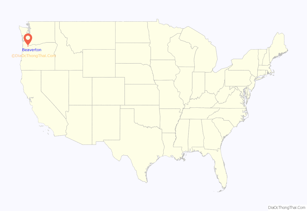
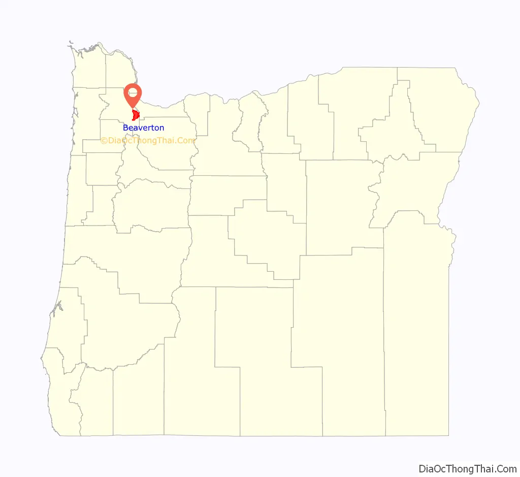
Beaverton location map. Where is Beaverton city?
History
Early settlement
According to Oregon Geographic Names, Beaverton’s name is derived from the settlement’s proximity to a large body of water resulting from beaver dams.
The area of Tualatin Valley that became Beaverton was originally the home of a Native American tribe known as the Atfalati, which settlers mispronounced as Tualatin. The Atfalati population dwindled in the latter part of the 18th century, and the prosperous tribe was no longer dominant in the area by the 19th century when settlers arrived. The tribe named their village Chakeipi, which translates to “place of the beaver,” which early settlers referred to as “Beaverdam.”
Early settlers include the Hall Family from Kentucky, the Denneys who lived on their claim near present-day Scholls Ferry Road and Hall Blvd, and Orin S. Allen, from western New York. Lawrence Hall purchased 640 acres (2.6 km) in Beaverdam in 1847 and built a grist mill with his brother near present-day Walker Road. His was the first land claim in the area. He was soon followed by Thomas Denney in 1848, who came to the area and built its first sawmill. In 1860, a toll plank road from Portland to Beaverton was completed over a trail called Canyon Road.
After the American Civil War, numerous other settlers, including Joshua Welch, George Betts, Charles Angel, W. P. Watson, and John Henry, laid out what is now known as Beaverton hoping they could bring a railroad to an area once described as, “mostly swamps & marshes connected by beaver dams to create what looked like a huge lake.” In 1872, Beaverton’s first post office opened in a general store operated by Betts, who also served as the first postmaster of the community. Betts Street, where the current post office now stands, is named in honor of him. In 1893, Beaverton, which by that time had a population of 400, was officially incorporated. Alonzo Cady, a local businessman, served as the first mayor. Many major roads in Beaverton are named for these early settlers.
20th century
Beaverton was an early home to automobile dealerships. A Ford Motor Company dealership was established there in 1915; it was purchased by Guy Carr in 1923 and over the years Carr expanded it into several locations throughout Beaverton. There are still several dealerships near the intersection of Walker and Canyon Roads.
In the early 1920s, Beaverton was home to Premium Picture Productions, a movie studio which produced about fifteen films. The studio site was later converted into Watt’s Field and associated aircraft manufacturing facilities. A second Beaverton airport, Bernard’s Airport, was later developed farther north, at the present location of the Cedar Hills Crossing mall.
The town’s first library opened in 1925. Originally on the second floor of the Cady building, it has been moved repeatedly; in 2000 it was moved to its current location on Hall Boulevard and 5th Street. A branch location was opened for the first time in June 2010, when the Murray-Scholls location opened near the Murrayhill neighborhood. The Beaverton libraries and 15 other local libraries participate in the Washington County Cooperative Library Services.
21st century
In December 2004, the city and Washington County announced an “interim plan” which would lead to Beaverton becoming the second-largest city in Oregon, second only to Portland. The “interim” plan actually covered a period of more than ten years; from the county’s perspective, the plan supported its strategy of having cities and special districts provide urban services. The city of Beaverton also attempted to annex certain businesses, including Nike, which responded with a legal and lobbying effort to resist the annexation. The lobbying effort succeeded quickly, with the Oregon Legislative Assembly enacting Senate Bill 887, which prohibited Beaverton from annexing Nike without the company’s consent. The bill also applied to property owned by Electro Scientific Industries, Columbia Sportswear, and Tektronix, and in August 2008 the Oregon Land Use Board of Appeals ruled that the bill also barred the city from annexing property belonging to Leupold & Stevens. (See below, under Economy.) Beaverton’s legal efforts to annex Nike cost the city over one million dollars. In 2016, Nike unveiled plans to expand its campus by 3.2 million square feet (approximately 300,000 square meters) at a projected cost of one billion dollars.
The Oregon State Legislature has also passed legislation which redetermined Washington County’s urban growth boundary to include more development. In 2018, the Metro Council voted to once again expand the urban growth boundary to include the Cooper Mountain urban reserve area.
In 2016, voters approved a $35 million bond for a new 75,000-square-foot (7,000 m) Public Safety Center built to withstand a major earthquake. The center, which opened in fall of 2020, now houses the city’s Emergency Management and Police Departments. Construction began in September 2018.
The city has tried to encourage transit-oriented development around the city’s MAX Light Rail stations. The Round, a mixed-use development around Beaverton Central MAX Station on the site of a former sewer plant, was announced in 1996. In 2014, the City of Beaverton moved its city hall into The Beaverton Building, an office building in The Round. The Round currently consists of 24,000 square foot of retail space with 63 residential condominiums located above. BG’s Food Cartel, Beaverton’s first food cart pod, opened in 2018 and has 31 food carts, a speakeasy bar, and an event venue. Adjacent to The Round, the 550 seat Patricia Reser Center for the Arts opened in 2022, and was made possible by pledges from the Beaverton Arts Foundation and Pat Reser along with public sources. The groundbreaking was performed on November 13, 2019. In addition to the Reser Center, a new 125-room hotel opened next to The Round in February of 2021. The performing arts center, apartments, city hall, hotel, MAX light rail station, plazas, food carts, and nearby businesses are collectively known as Downtown Beaverton.
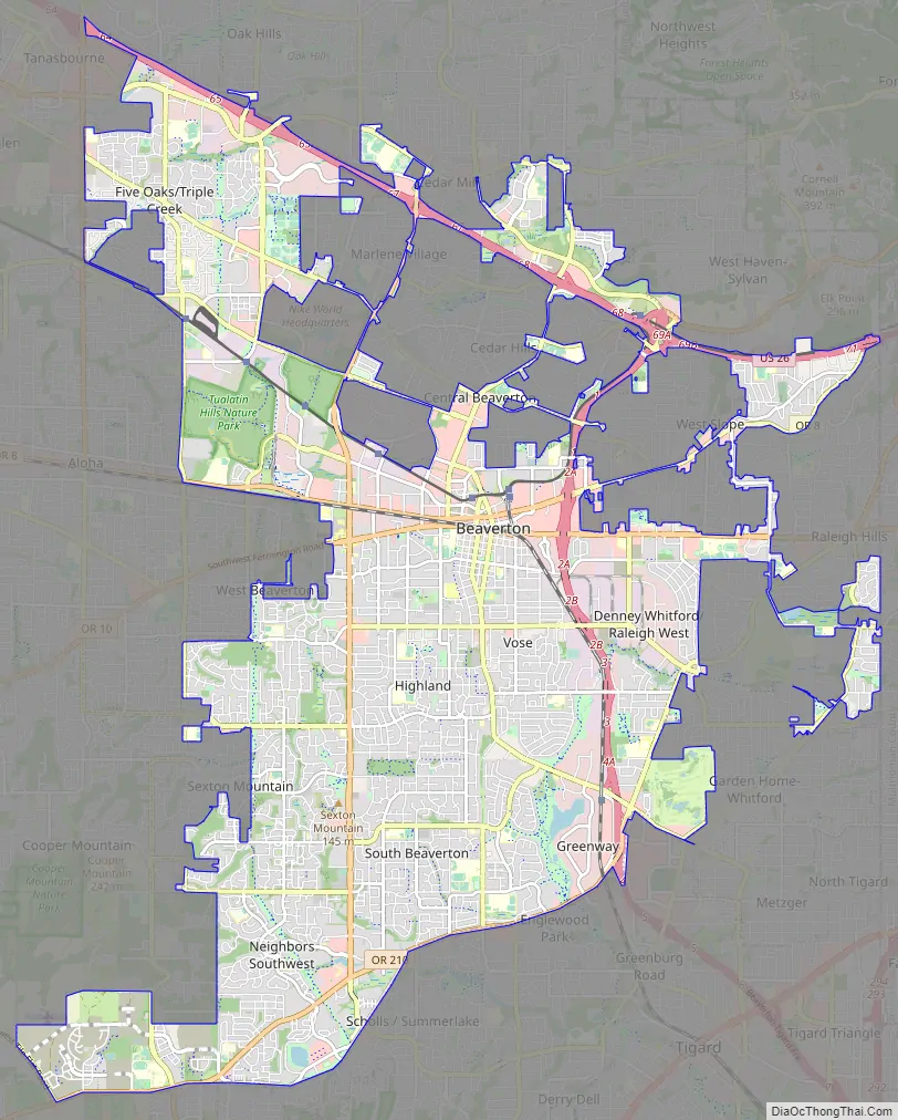
Beaverton Road Map
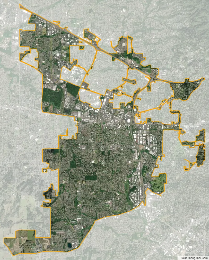
Beaverton city Satellite Map
Geography
Beaverton covers a total area of 19.7 square miles (51 km), all of it land except for small creeks, ponds, and lakes. The city is located along the eastern edge of the Tualatin Valley just west of the Tualatin Mountains. It is bordered by Portland to the east, Hillsboro to the west, and Tigard to the south. Much of the remaining area surrounding Beaverton in the north and southwest constitutes unincorporated Washington County land. The elevation within city limits ranges from as high as 698.2 feet (212.8 m) above sea level to as low as 131.7 feet (40.1 m) above sea level. The city averages at 189 feet (58 m) above sea level.
Neighborhoods
The city of Beaverton is divided into 13 neighborhoods: Central Beaverton, Denney Whitford, Raleigh West, Five Oaks, Triple Creek, Greenway, Highland, Neighbors Southwest, Sexton Mountain, South Beaverton, Vose, West Beaverton, and West Slope. Each neighborhood runs a Neighborhood Association Committee (NAC) to discuss neighborhood affairs, with the exception of Five Oaks and Triple Creek, and Denney Whitford and Raleigh West each sharing a NAC.
Climate
See also
Map of Oregon State and its subdivision: Map of other states:- Alabama
- Alaska
- Arizona
- Arkansas
- California
- Colorado
- Connecticut
- Delaware
- District of Columbia
- Florida
- Georgia
- Hawaii
- Idaho
- Illinois
- Indiana
- Iowa
- Kansas
- Kentucky
- Louisiana
- Maine
- Maryland
- Massachusetts
- Michigan
- Minnesota
- Mississippi
- Missouri
- Montana
- Nebraska
- Nevada
- New Hampshire
- New Jersey
- New Mexico
- New York
- North Carolina
- North Dakota
- Ohio
- Oklahoma
- Oregon
- Pennsylvania
- Rhode Island
- South Carolina
- South Dakota
- Tennessee
- Texas
- Utah
- Vermont
- Virginia
- Washington
- West Virginia
- Wisconsin
- Wyoming