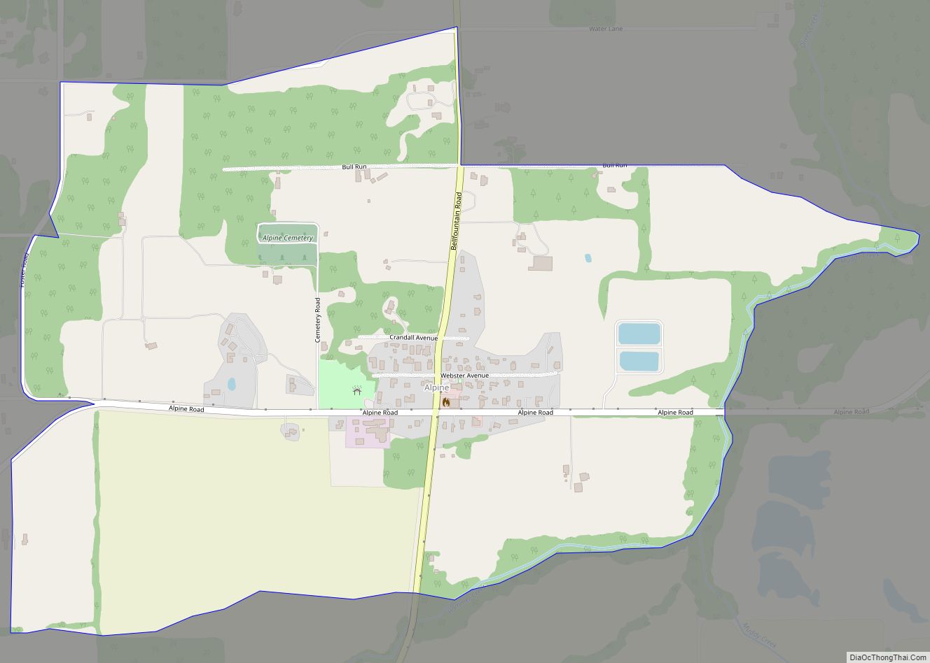
Map of Adams city, Oregon

Map of Adams city, Oregon

Adams is a city in Umatilla County, Oregon, United States, located about 13 miles (21 km) northeast of Pendleton on Oregon Route 11. The population was 350 at the 2010 census. It is part of the Pendleton–Hermiston Micropolitan Statistical Area. Adams city overview: Name: Adams city LSAD Code: 25 LSAD Description: city (suffix) State: Oregon County: … Read more

Map of Adair Village city

Map of Adair Village city

Adair Village is a city in Benton County, Oregon, United States. The population was 840 at the 2010 census. Adair Village city overview: Name: Adair Village city LSAD Code: 25 LSAD Description: city (suffix) State: Oregon County: Benton County Incorporated: 1976 Elevation: 328 ft (100 m) Total Area: 0.44 sq mi (1.15 km²) Land Area: 0.44 sq mi (1.15 km²) Water Area: 0.00 sq mi … Read more

Map of Astoria city, Oregon

Map of Astoria city, Oregon

Astoria is a port city and the seat of Clatsop County, Oregon, United States. Founded in 1811, Astoria is the oldest city in the state and was the first permanent American settlement west of the Rocky Mountains. The county is the northwest corner of Oregon, and Astoria is located on the south shore of the … Read more

Map of Ashland city, Oregon

Map of Ashland city, Oregon

Ashland is a city in Jackson County, Oregon, United States. It lies along Interstate 5 approximately 16 miles (26 km) north of the California border and near the south end of the Rogue Valley. The city’s population was 21,360 at the 2020 census. The city is the home of Southern Oregon University (SOU) and the Oregon … Read more

Map of Arlington city, Oregon

Map of Arlington city, Oregon

Arlington is a city in Gilliam County, Oregon, United States. The city’s population was 586 at the 2010 census and has a 2019 estimate of 591. Arlington city overview: Name: Arlington city LSAD Code: 25 LSAD Description: city (suffix) State: Oregon County: Gilliam County Incorporated: 1885 Elevation: 285 ft (86.87 m) Total Area: 3.17 sq mi (8.21 km²) Land Area: … Read more

Map of Antelope city, Oregon

Map of Antelope city, Oregon

Antelope (known as Rajneesh from 1984 to 1986) is a town in rural Wasco County, Oregon, United States. Antelope had an estimated population of 47 people in 2012. Antelope city overview: Name: Antelope city LSAD Code: 25 LSAD Description: city (suffix) State: Oregon County: Wasco County Incorporated: 1901 Elevation: 2,654 ft (809 m) Total Area: 0.46 sq mi (1.19 km²) … Read more

Map of Annex CDP

Map of Annex CDP

Annex is an unincorporated community and census-designated place in Malheur County, Oregon, United States. Its population was 235 as of the 2010 census. The community is located on the south bank of the Snake River across from Weiser, Idaho; a bridge carrying U.S. Route 95 Spur connects the two. Annex CDP overview: Name: Annex CDP … Read more

Map of Bandon city

Map of Bandon city

Bandon (/ˈbændən/) is a city in Coos County, Oregon, United States, on the south side of the mouth of the Coquille River. It was named by George Bennet, an Irish peer, who settled nearby in 1873 and named the town after Bandon in Ireland, his hometown. The population was 3,066 at the 2010 census and … Read more

Map of Baker City city

Map of Baker City

Baker City is a city in and the county seat of Baker County, Oregon, United States. It was named after Edward Dickinson Baker, the only U.S. Senator ever killed in military combat. The population was 10,099 at the time of the 2020 census. Baker City overview: Name: Baker City LSAD Code: 25 LSAD Description: city … Read more

Map of Aurora city, Oregon

Map of Aurora city, Oregon

Aurora is a city in Marion County, Oregon, United States and is home to the nation’s largest not-for-profit air ambulance company, Life Flight Network. Before being incorporated as a city, it was the location of the Aurora Colony, a religious commune founded in 1856 by William Keil and John E. Schmit. William named the settlement … Read more

Map of Aumsville city

Map of Aumsville city

Aumsville is a city in Marion County, Oregon, United States. The population was 4,234 at the 2020 census. It is part of the Salem Metropolitan Statistical Area. Aumsville city overview: Name: Aumsville city LSAD Code: 25 LSAD Description: city (suffix) State: Oregon County: Marion County Incorporated: August 3, 1911 Elevation: 366 ft (112 m) Total Area: 1.13 sq mi … Read more

Map of Athena city

Map of Athena city

Athena is a city in Umatilla County, Oregon, United States. The population was 1,126 at the 2010 census. It is part of the Hermiston-Pendleton Micropolitan Statistical Area. Athena city overview: Name: Athena city LSAD Code: 25 LSAD Description: city (suffix) State: Oregon County: Umatilla County Incorporated: 1904 Elevation: 1,710 ft (520 m) Total Area: 0.55 sq mi (1.42 km²) Land … Read more