Map of Wyoming city, Michigan
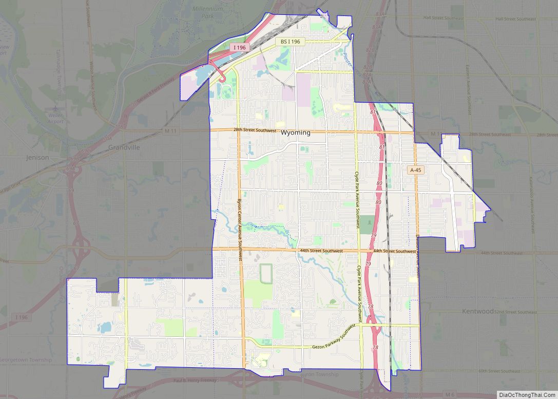
Wyoming city overview: Name: Wyoming city LSAD Code: 25 LSAD Description: city (suffix) State: Michigan County: Kent County Incorporated: 1959 Elevation: 666 ft (203 m) Total Area: 24.95 sq mi (64.62 km²) Land Area: 24.74 sq mi (64.08 km²) Water Area: 0.21 sq mi (0.54 km²) Total Population: 76,501 Population Density: 3,092.07/sq mi (1,193.84/km²) Area code: 616 FIPS code: 2688940 GNISfeature ID: 1627295 Online Interactive Map Wyoming ... Read more
Map of Wyoming city, Michigan
Map of Wyandotte city, Michigan
Wyandotte (/ˈwaɪəndɒt/ WY-ən-dot) is a city in Wayne County in the U.S. state of Michigan. The population was 25,058 at the 2020 census. Wyandotte is located in southeastern Michigan, approximately 11 miles (18 km) south of Detroit on the Detroit River, and it is part of the collection of communities known as Downriver. Wyandotte is bounded ... Read more
Map of Wyandotte city, Michigan
Map of Zilwaukee city
Zilwaukee is a city in Saginaw County in the U.S. state of Michigan. The 2020 census places the population at 1,534. The city is adjacent to and was created from Zilwaukee Township. It is the home of the Zilwaukee Bridge. Zilwaukee city overview: Name: Zilwaukee city LSAD Code: 25 LSAD Description: city (suffix) State: Michigan ... Read more
Map of Zilwaukee city
Map of Zeeland city, Michigan
Zeeland (/ˈziːlənd/ ZEE-lənd) is a city in Ottawa County in the U.S. state of Michigan. The population was 5,719 at the 2020 census. The city is located at the western edge of Zeeland Charter Township. Its name is taken from the Dutch province of Zeeland. Zeeland city overview: Name: Zeeland city LSAD Code: 25 LSAD ... Read more
Map of Zeeland city, Michigan
Map of Adrian city, Minnesota
Adrian is a city in Nobles County, Minnesota, United States. The population was 1,209 at the 2010 census. Adrian city overview: Name: Adrian city LSAD Code: 25 LSAD Description: city (suffix) State: Minnesota County: Nobles County Elevation: 1,562 ft (476 m) Total Area: 1.17 sq mi (3.03 km²) Land Area: 1.17 sq mi (3.03 km²) Water Area: 0.00 sq mi (0.00 km²) Total Population: 1,194 Population ... Read more
Map of Adrian city, Minnesota
Map of Adams city, Minnesota
Adams is a city in Adams Township, Mower County, Minnesota, United States. The population was 787 at the 2010 census. Adams city overview: Name: Adams city LSAD Code: 25 LSAD Description: city (suffix) State: Minnesota County: Mower County Elevation: 1,286 ft (392 m) Total Area: 1.00 sq mi (2.60 km²) Land Area: 1.00 sq mi (2.60 km²) Water Area: 0.00 sq mi (0.00 km²) Total Population: ... Read more
Map of Adams city, Minnesota
Map of Ada city, Minnesota
Ada (/ˈeɪdə/ AY-də) is a city in Norman County, Minnesota, United States. The population was 1,740 at the 2020 census. It is the county seat. Minnesota State Highways 9 and 200 are two of the main routes in the city. Ada city overview: Name: Ada city LSAD Code: 25 LSAD Description: city (suffix) State: Minnesota ... Read more
Map of Ada city, Minnesota
Map of Albert Lea city
Albert Lea is a city in Freeborn County, in southern Minnesota. It is the county seat. Its population was 18,492 at the 2020 census. The city is at the junction of Interstates 35 and 90, about 90 miles (140 km) south of the Twin Cities. It is on the shores of Fountain Lake, Pickerel Lake, Albert ... Read more
Map of Albert Lea city
Map of Albany city, Minnesota
Albany is a city in Stearns County, Minnesota, United States. The population was 2,561 at the 2010 census. It is part of the St. Cloud Metropolitan Statistical Area. Albany city overview: Name: Albany city LSAD Code: 25 LSAD Description: city (suffix) State: Minnesota County: Stearns County Elevation: 1,204 ft (367 m) Total Area: 2.28 sq mi (5.92 km²) Land Area: ... Read more
Map of Albany city, Minnesota
Map of Akeley city
Akeley (/ˈeɪkli/ AYK-lee) is a city in Hubbard County, Minnesota, United States. The population was 404 at the 2020 census. Akeley city overview: Name: Akeley city LSAD Code: 25 LSAD Description: city (suffix) State: Minnesota County: Hubbard County Elevation: 1,430 ft (436 m) Total Area: 1.49 sq mi (3.87 km²) Land Area: 1.47 sq mi (3.80 km²) Water Area: 0.03 sq mi (0.07 km²) Total Population: ... Read more
Map of Akeley city
Map of Aitkin city
Aitkin (/ˈeɪkɪn/ AY-kin) is a city in Aitkin County, Minnesota, United States. The population was 2,168 at the 2020 census. It is the county seat of Aitkin County. Aitkin city overview: Name: Aitkin city LSAD Code: 25 LSAD Description: city (suffix) State: Minnesota County: Aitkin County Incorporated: August 19, 1889 Elevation: 1,214 ft (370 m) Total Area: ... Read more
Map of Aitkin city
Map of Afton city, Minnesota
Afton is a city in Washington County, Minnesota, United States. The population was 2,886 at the 2010 United States Census. It lies on a small bay where Valley Creek empties into the St. Croix River, several miles north of its confluence with the Mississippi River. Afton is well known for Afton Alps, the largest ski ... Read more
Map of Afton city, Minnesota