Map of Marfa city
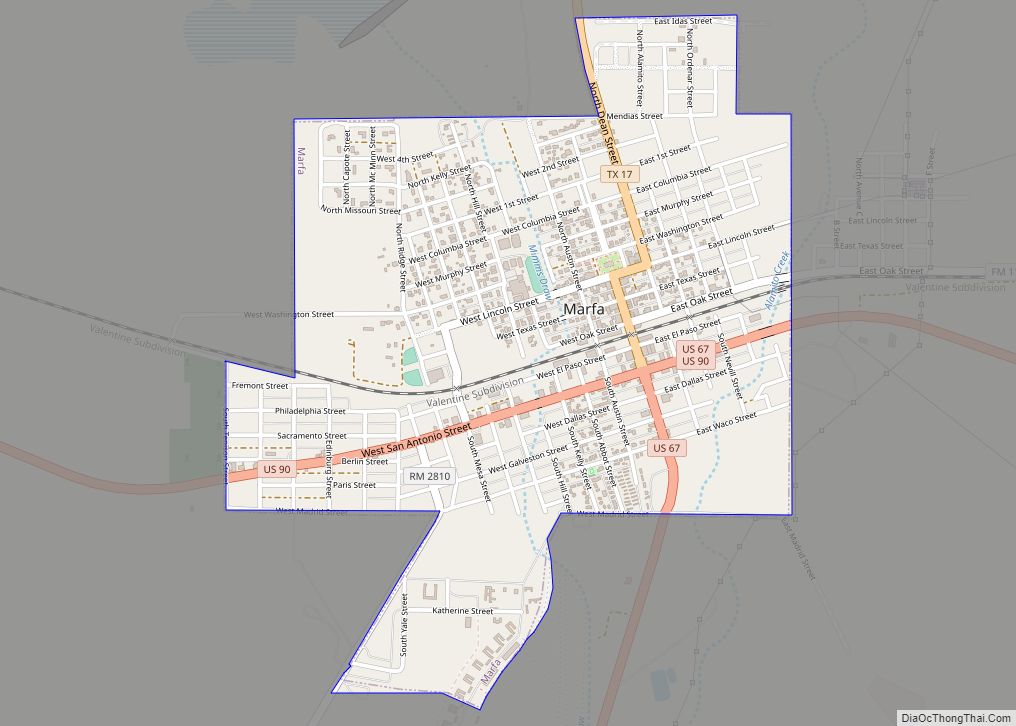
Marfa is a city in the high desert of the Trans-Pecos in far West Texas, between the Davis Mountains and Big Bend National Park. It is the county seat of Presidio County, and its population as of the 2010 United States Census was 1,981. The city was founded in the early 1880s as a water ... Read more
Map of Marfa city
Map of Marble Falls city
Marble Falls is a city in Burnet County, Texas, United States. As of the 2020 United States Census, the city population was 7,033. Lake Marble Falls is part of the Highland Lakes on the Colorado River, the largest chain of lakes in Texas. Marble Falls was founded by Adam Rankin Johnson in 1887, a former ... Read more
Map of Marble Falls city
Map of Martinez CDP, Texas
Martinez is a census-designated place (CDP) in Starr County, Texas, United States. This was a new CDP for the 2010 census with a population of 69. Martinez CDP overview: Name: Martinez CDP LSAD Code: 57 LSAD Description: CDP (suffix) State: Texas County: Starr County Total Area: 0.1 sq mi (0.3 km²) Land Area: 0.1 sq mi (0.3 km²) Water Area: 0.0 sq mi ... Read more
Map of Martinez CDP, Texas
Map of McDade CDP
McDade is an unincorporated community and census-designated place in northern Bastrop County, Texas, located along U.S. Route 290. As of the 2020 census, it had a population of 720. It is 9 miles (14 km) east of Elgin and 34 miles (55 km) east of Austin. It is 21 miles (34 km) west of Giddings. McDade CDP overview: ... Read more
Map of McDade CDP
Map of McCamey city
McCamey is a city in Upton County, Texas. Its population was 1,887 at the 2010 census. The Texas legislature has declared McCamey “the Wind Energy Capital of Texas” because of the many wind farms that have been built in the area. Its history, however, is primarily that of an oil boomtown. McCamey city overview: Name: ... Read more
Map of McCamey city
Map of Maypearl city
Maypearl is a city in Ellis County, Texas, United States. The population was 939 in 2020. Maypearl city overview: Name: Maypearl city LSAD Code: 25 LSAD Description: city (suffix) State: Texas County: Ellis County Elevation: 531 ft (162 m) Total Area: 0.83 sq mi (2.14 km²) Land Area: 0.81 sq mi (2.10 km²) Water Area: 0.02 sq mi (0.05 km²) Total Population: 939 Population Density: 1,100/sq mi ... Read more
Map of Maypearl city
Map of Mauriceville CDP
Mauriceville is a census-designated place (CDP) in Orange County, Texas, United States. The population was 2,983 at the 2020 census. It is part of the Beaumont–Port Arthur Metropolitan Statistical Area. Mauriceville CDP overview: Name: Mauriceville CDP LSAD Code: 57 LSAD Description: CDP (suffix) State: Texas County: Orange County Elevation: 26 ft (8 m) Total Area: 8.5 sq mi (22.0 km²) ... Read more
Map of Mauriceville CDP
Map of Maud city, Texas
Maud is a city in Bowie County, Texas, United States, within the Texarkana metropolitan area. According to the 2020 U.S. census, it had a population of 977. Maud city overview: Name: Maud city LSAD Code: 25 LSAD Description: city (suffix) State: Texas County: Bowie County Elevation: 289 ft (88 m) Total Area: 1.49 sq mi (3.86 km²) Land Area: 1.49 sq mi ... Read more
Map of Maud city, Texas
Map of Mathis city
Mathis is a city in San Patricio County, Texas, United States. The population was 4,942 at the 2010 census. Mathis city overview: Name: Mathis city LSAD Code: 25 LSAD Description: city (suffix) State: Texas County: San Patricio County Elevation: 161 ft (49 m) Total Area: 3.32 sq mi (8.59 km²) Land Area: 3.32 sq mi (8.59 km²) Water Area: 0.00 sq mi (0.00 km²) Total Population: ... Read more
Map of Mathis city
Map of Matagorda CDP
Matagorda (/ˈmætəˈɡɔːrdə/ (listen)) is a census-designated place in Matagorda County, Texas. It is located near the mouth of the Colorado River on the upper Texas coast in the United States. In 2020, its population was 313. Matagorda is primarily a tourist town, with commercial and recreational fishing being the top industries. About 23 miles (37 km) ... Read more
Map of Matagorda CDP
Map of Matador town
Matador is a town in and the county seat of Motley County, Texas, United States. Its population was 607 at the 2010 census. In 1891, it was established by and named for the Matador Ranch. It is located 95 miles (153 km) east of Lubbock, Texas. Matador town overview: Name: Matador town LSAD Code: 43 LSAD ... Read more
Map of Matador town
Map of Mason city, Texas
Mason is a city in, and the county seat of, Mason County, Texas, United States. The city is an agricultural community on Comanche Creek southwest of Mason Mountain, on the Edwards Plateau and part of the Llano Uplift. Its population was 2,114 at the 2010 census. Mason city overview: Name: Mason city LSAD Code: 25 ... Read more
Map of Mason city, Texas