Map of Purdy CDP, Washington
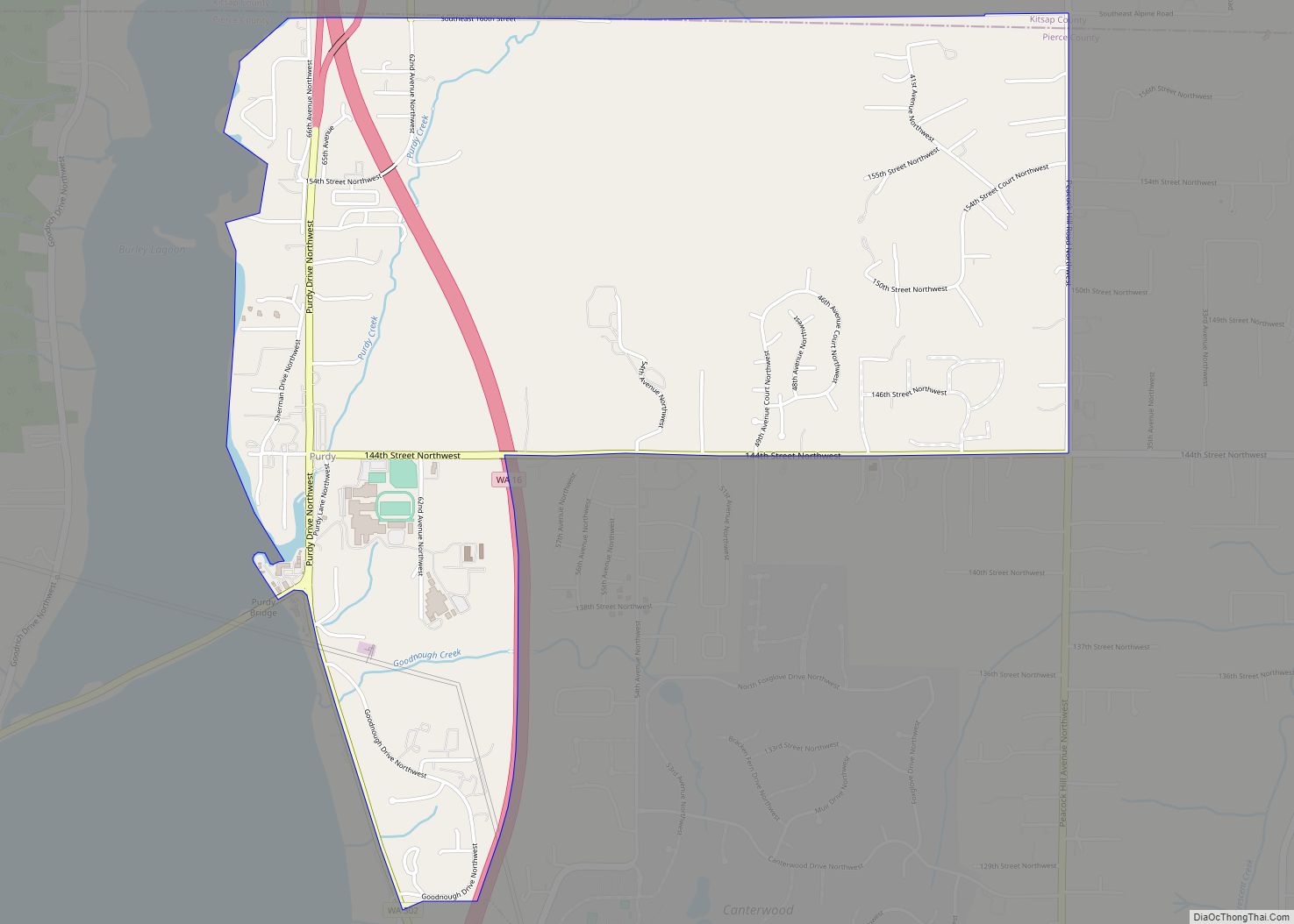
Purdy is a small unincorporated community and census-designated place north of the city of Gig Harbor, at the junction of Washington State Routes 16 and 302 on the northern boundary of Pierce County, Washington. It is located on the shores of Burley Lagoon and Henderson Bay, Washington of the Carr Inlet. The two bodies of ... Read more
Map of Purdy CDP, Washington
Map of Pullman city, Washington
Pullman (/ˈpʊlmən/) is the largest city in Whitman County, located in southeastern Washington within the Palouse region of the Pacific Northwest. The population was 29,799 at the 2010 census, and estimated to be 34,506 in 2019. Originally founded as Three Forks, the city was renamed after industrialist George Pullman in 1884. Pullman is noted as ... Read more
Map of Pullman city, Washington
Map of Puget Island CDP
Puget Island is a 7.5 sq mi(4,785 acre; 19.365 km) island and Census-designated place (CDP) in the Columbia River in Wahkiakum County, Washington, United States. The Julia Butler Hansen Bridge (built in 1938) carries State Route 409 across the Cathlamet Channel to connect the island to the town of Cathlamet, Washington. Route 409 crosses the island ... Read more
Map of Puget Island CDP
Map of Prosser city, Washington
Prosser (/ˈprɑːsər/) is a city in and the county seat of Benton County, Washington, United States. Situated along the Yakima River, it had a population of 6,062 at the 2020 census. Prosser city overview: Name: Prosser city LSAD Code: 25 LSAD Description: city (suffix) State: Washington County: Benton County Elevation: 666 ft (203 m) Total Area: 4.79 sq mi ... Read more
Map of Prosser city, Washington
Map of Prescott city, Washington
Prescott is a city in central Walla Walla County, Washington. The population was 318 at the 2010 census. Prescott city overview: Name: Prescott city LSAD Code: 25 LSAD Description: city (suffix) State: Washington County: Walla Walla County Elevation: 1,056 ft (322 m) Total Area: 0.40 sq mi (1.03 km²) Land Area: 0.40 sq mi (1.03 km²) Water Area: 0.00 sq mi (0.00 km²) Total Population: 318 ... Read more
Map of Prescott city, Washington
Map of Prairie Ridge CDP
Prairie Ridge is a census-designated place (CDP) in Pierce County, Washington, United States. The population was 12,288 at the 2020 census. Prairie Ridge CDP overview: Name: Prairie Ridge CDP LSAD Code: 57 LSAD Description: CDP (suffix) State: Washington County: Pierce County Elevation: 686 ft (209 m) Total Area: 4.3 sq mi (11.1 km²) Land Area: 4.3 sq mi (11.0 km²) Water Area: 0.0 sq mi ... Read more
Map of Prairie Ridge CDP
Map of Prairie Heights CDP
Prairie Heights is a census-designated place (CDP) located in Pierce County, Washington. Prairie Heights CDP overview: Name: Prairie Heights CDP LSAD Code: 57 LSAD Description: CDP (suffix) State: Washington County: Pierce County Elevation: 666 ft (203 m) Total Area: 3.74 sq mi (9.7 km²) Total Population: 4,405 Population Density: 1,200/sq mi (450/km²) Area code: 360 FIPS code: 5356150 Online Interactive Map ... Read more
Map of Prairie Heights CDP
Map of Poulsbo city
Poulsbo (/ˈpɔːlzboʊ/ PAWLZ-boh) is a city on Liberty Bay in Kitsap County, Washington, United States. It is the smallest of the four cities in Kitsap County. The population was 9,200 at the 2010 census and an estimated 10,927 in 2018. The area was historically inhabited by the Suquamish people, many of whom moved to the ... Read more
Map of Poulsbo city
Map of Porter CDP, Washington
Porter is an unincorporated community and census-designated place (CDP) in Grays Harbor County, Washington, United States. The population was 207 at the 2010 census. Prior to 2010 it was part of the Malone-Porter CDP; Malone and Porter are now separate CDPs. They are located just off U.S. Route 12, southeast of Elma and northwest of ... Read more
Map of Porter CDP, Washington
Map of Port Townsend city
Port Townsend /ˈtaʊnzənd/ is a city on the Quimper Peninsula in Jefferson County, Washington, United States. The population was 10,148 at the 2020 United States Census. It is the county seat and only incorporated city of Jefferson County. In addition to its natural scenery at the northeast tip of the Olympic Peninsula, the city is ... Read more
Map of Port Townsend city
Map of Raft Island CDP
Raft Island is a private island and CDP located near the Pierce County community of Rosedale, Washington, United States. Gig Harbor, Washington is the nearest incorporated town, although unincorporated Artondale is much closer. The island features approximately 200 homes on 160 acres. All of these homes are served through the Gig Harbor post office. Raft ... Read more
Map of Raft Island CDP
Map of Port Orchard city
Port Orchard is a city in and the county seat of Kitsap County, Washington, United States. It is located 13 miles (21 km) due west of West Seattle and is connected to Seattle and Vashon Island via the Washington State Ferries run to Southworth. It is named after Port Orchard, the strait that separates Bainbridge Island ... Read more
Map of Port Orchard city