Map of New Berlin city, Wisconsin
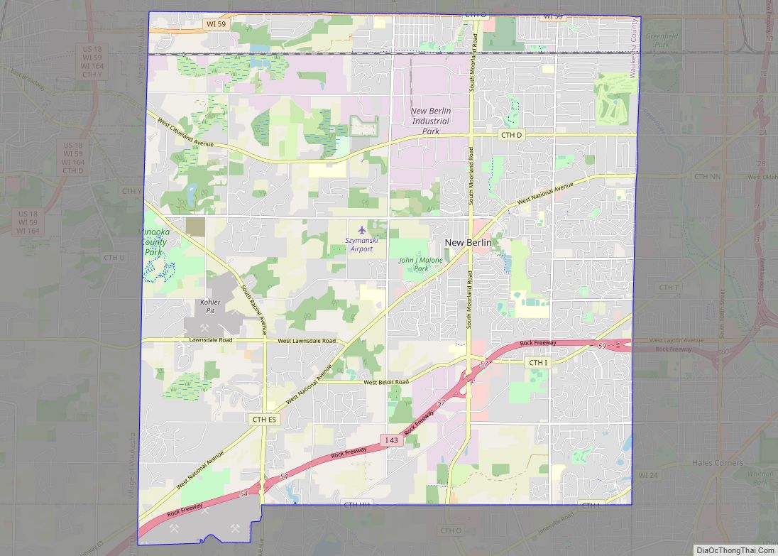
New Berlin (/nuːˈbɜːrlɪn/) is a city located in eastern Waukesha County in the U.S. state of Wisconsin. The population was 40,451 at the 2020 census, making it the third-largest community in Waukesha County after the cities of Waukesha and Brookfield. New Berlin city overview: Name: New Berlin city LSAD Code: 25 LSAD Description: city (suffix) ... Read more
Map of New Berlin city, Wisconsin
Map of North Hudson village
North Hudson is a village in St. Croix County, Wisconsin, United States. The population was 3,768 at the 2010 census. North Hudson village overview: Name: North Hudson village LSAD Code: 47 LSAD Description: village (suffix) State: Wisconsin County: St. Croix County Elevation: 741 ft (226 m) Total Area: 2.43 sq mi (6.30 km²) Land Area: 1.57 sq mi (4.06 km²) Water Area: 0.87 sq mi ... Read more
Map of North Hudson village
Map of Nichols village, Wisconsin
Nichols is a village in Outagamie County, Wisconsin, United States. The population was 273 at the 2010 census. Nichols village overview: Name: Nichols village LSAD Code: 47 LSAD Description: village (suffix) State: Wisconsin County: Outagamie County Elevation: 791 ft (241 m) Total Area: 0.89 sq mi (2.29 km²) Land Area: 0.89 sq mi (2.29 km²) Water Area: 0.00 sq mi (0.00 km²) Total Population: 273 Population ... Read more
Map of Nichols village, Wisconsin
Map of Niagara city, Wisconsin
Niagara is a city in Marinette County, Wisconsin, United States. The population was 1,624 at the 2010 census. The city lies to the north of and adjacent to the Town of Niagara. It is part of the Marinette, WI–MI Micropolitan Statistical Area. Niagara city overview: Name: Niagara city LSAD Code: 25 LSAD Description: city (suffix) ... Read more
Map of Niagara city, Wisconsin
Map of Newburg village, Wisconsin
Newburg is a village in Ozaukee and Washington Counties in the U.S. state of Wisconsin. The population was 1,254 at the 2010 census. Of this, 1,157 were in Washington County, and only 97 were in Ozaukee County. Newburg village overview: Name: Newburg village LSAD Code: 47 LSAD Description: village (suffix) State: Wisconsin County: Ozaukee County, ... Read more
Map of Newburg village, Wisconsin
Map of New Odanah CDP
New Odanah is a census-designated place in the town of Sanborn, Ashland County, Wisconsin, United States. Its population was 466 as of the 2020 census. New Odanah is located on the Bad River Indian Reservation. In local parlance, New Odanah is considered part of Odanah, which is the only name that appears on Wisconsin DOT ... Read more
Map of New Odanah CDP
Map of New London city, Wisconsin
New London is a city in Outagamie and Waupaca counties Wisconsin, United States. Founded in 1851, the population was 7,295 at the 2010 census. Of this, 5,685 were in Waupaca County, and 1,640 were in Outagamie County. The city has an annual Saint Patrick’s Day Parade, Irish Fest, and week-long festivities, when the city’s name ... Read more
Map of New London city, Wisconsin
Map of Oregon village, Wisconsin
Oregon is a village in Dane County, Wisconsin. As of the census of 2020, the population was 11,179. Oregon is part of the Madison Metropolitan Statistical Area. The village is located mostly within the Town of Oregon. Oregon village overview: Name: Oregon village LSAD Code: 47 LSAD Description: village (suffix) State: Wisconsin County: Dane County ... Read more
Map of Oregon village, Wisconsin
Map of Oostburg village
Oostburg is a village in Sheboygan County, Wisconsin, United States. The population was 2,887 at the 2010 census. It is included in the Sheboygan, Wisconsin Metropolitan Statistical Area. Oostburg village overview: Name: Oostburg village LSAD Code: 47 LSAD Description: village (suffix) State: Wisconsin County: Sheboygan County Elevation: 699 ft (213 m) Total Area: 1.96 sq mi (5.08 km²) Land Area: ... Read more
Map of Oostburg village
Map of Ontario village, Wisconsin
Ontario is a village in Vernon County, Wisconsin, United States. The population was 554 at the 2010 census. Ontario village overview: Name: Ontario village LSAD Code: 47 LSAD Description: village (suffix) State: Wisconsin County: Vernon County Elevation: 919 ft (280 m) Total Area: 1.01 sq mi (2.62 km²) Land Area: 1.00 sq mi (2.60 km²) Water Area: 0.01 sq mi (0.02 km²) Total Population: 554 Population ... Read more
Map of Ontario village, Wisconsin
Map of Onalaska city, Wisconsin
Onalaska is a city in La Crosse County, Wisconsin, United States. The population was 18,803 at the 2020 census. It borders the larger La Crosse, Wisconsin, and is a part of the La Crosse-Onalaska, WI-MN Metropolitan Area. Onalaska is built on a slightly elevated ridge above the Black River. Natural areas include both river bottom ... Read more
Map of Onalaska city, Wisconsin
Map of Oliver village, Wisconsin
Oliver is a village in Douglas County, Wisconsin, United States. The population was 423 at the 2020 census. Oliver is located 5 miles (8.0 km) west of the city of Superior and 0.3 miles (0.48 km) east of Gary – New Duluth, Duluth, Minnesota. Oliver village overview: Name: Oliver village LSAD Code: 47 LSAD Description: village (suffix) ... Read more
Map of Oliver village, Wisconsin