Map of Yuba village
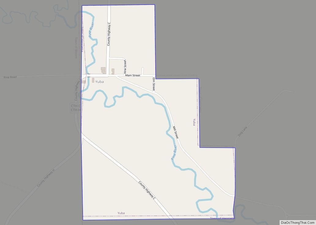
Yuba is a village in Richland County, Wisconsin, United States. The population was 74 at the 2010 census. Yuba is 11 miles southwest of Hillsboro and 17 miles north of Richland Center. County Hwy C runs through the village. South of Yuba, looking north Inside St. Wenceslaus Church North of Yuba (population 77), looking south ... Read more
Map of Yuba village
Map of Yorkville village, Wisconsin
Yorkville is a village in Racine County, Wisconsin, United States. The population was 3,246 at the 2020 census. The unincorporated communities of Ives Grove, Sylvania, and Yorkville are located in the town. Yorkville village overview: Name: Yorkville village LSAD Code: 47 LSAD Description: village (suffix) State: Wisconsin County: Racine County Elevation: 709 ft (216 m) Total Area: ... Read more
Map of Yorkville village, Wisconsin
Map of Wyocena village
Wyocena is a town in Columbia County, Wisconsin, United States. The population was 619 at the 2000 Census. The Village of Wyocena is located within the town. Wyocena village overview: Name: Wyocena village LSAD Code: 47 LSAD Description: village (suffix) State: Wisconsin County: Columbia County FIPS code: 5589300 Online Interactive Map Wyocena online map. Source: ... Read more
Map of Wyocena village
Map of Wyeville village
Wyeville is a village in Monroe County, Wisconsin, United States. It is located on Wisconsin Highway 21. The population was 147 at the 2010 census. Wyeville village overview: Name: Wyeville village LSAD Code: 47 LSAD Description: village (suffix) State: Wisconsin County: Monroe County Elevation: 919 ft (280 m) Total Area: 0.56 sq mi (1.46 km²) Land Area: 0.56 sq mi (1.46 km²) Water ... Read more
Map of Wyeville village
Map of Alderson town, West Virginia
Alderson is a town in Greenbrier and Monroe counties in the U.S. state of West Virginia, on both sides of the Greenbrier River. The population was 975 at the 2020 census. Alderson town overview: Name: Alderson town LSAD Code: 43 LSAD Description: town (suffix) State: West Virginia County: Greenbrier County, Monroe County Elevation: 1,549 ft (472 m) ... Read more
Map of Alderson town, West Virginia
Map of Albright town
Albright is a town in central Preston County, West Virginia, United States, along the Cheat River. The population was 260 at the 2020 census. A former coal town, it is part of the Morgantown metropolitan area. Albright town overview: Name: Albright town LSAD Code: 43 LSAD Description: town (suffix) State: West Virginia County: Preston County ... Read more
Map of Albright town
Map of Addison (Webster Springs) town
Addison (Webster Springs) town overview: Name: Addison (Webster Springs) town LSAD Code: 43 LSAD Description: town (suffix) State: West Virginia County: Webster County FIPS code: 5400364 Online Interactive Map Addison (Webster Springs) online map. Source: Basemap layers from Google Map, Open Street Map (OSM), Arcgisonline, Wmflabs. Boundary Data from Database of Global Administrative Areas. Addison ... Read more
Map of Addison (Webster Springs) town
Map of Bergoo CDP
Bergoo is a census-designated place (CDP) in Webster County, West Virginia, United States. As of the 2010 census, its population was 94. Bergoo lies at the confluence of the Elk River and Leatherwood Creek. Bergoo was formerly known as Leatherwood, taking its name from the creek. Some say Bergoo was the name of a local ... Read more
Map of Bergoo CDP
Map of Belva CDP
Belva is an unincorporated community and census-designated place in west Nicholas County and north Fayette County, West Virginia, United States; while the CDP only includes the Nicholas County portion, the Fayette County portion is considered part of the community. The town is situated at the bottomland surrounding the convergence of Bells Creek with Twentymile Creek ... Read more
Map of Belva CDP
Map of Belmont city, West Virginia
Belmont is a town in Pleasants County, West Virginia, United States. It is part of the Parkersburg–Vienna metropolitan area. The population was 872 at the 2020 census. Belmont was incorporated on April 19, 1946 by the Circuit Court of Pleasants County. The city was named for the beautiful hills (beau mont) in the area. Belmont ... Read more
Map of Belmont city, West Virginia
Map of Belington town
Belington is a town in Barbour County, West Virginia, United States, situated along the Tygart Valley River. The population was 1,804 as of the 2020 census. Belington town overview: Name: Belington town LSAD Code: 43 LSAD Description: town (suffix) State: West Virginia County: Barbour County Incorporated: 1894-08-22 Elevation: 1,703 ft (519 m) Total Area: 2.13 sq mi (5.52 km²) Land ... Read more
Map of Belington town
Map of Beech Bottom village
Beech Bottom is a village in Brooke County, West Virginia, United States, situated along the Ohio River. The population was 523 at the 2010 census. It is part of the Weirton–Steubenville metropolitan area. Beech Bottom village overview: Name: Beech Bottom village LSAD Code: 47 LSAD Description: village (suffix) State: West Virginia County: Brooke County Elevation: ... Read more
Map of Beech Bottom village