Map of Gilcrest town
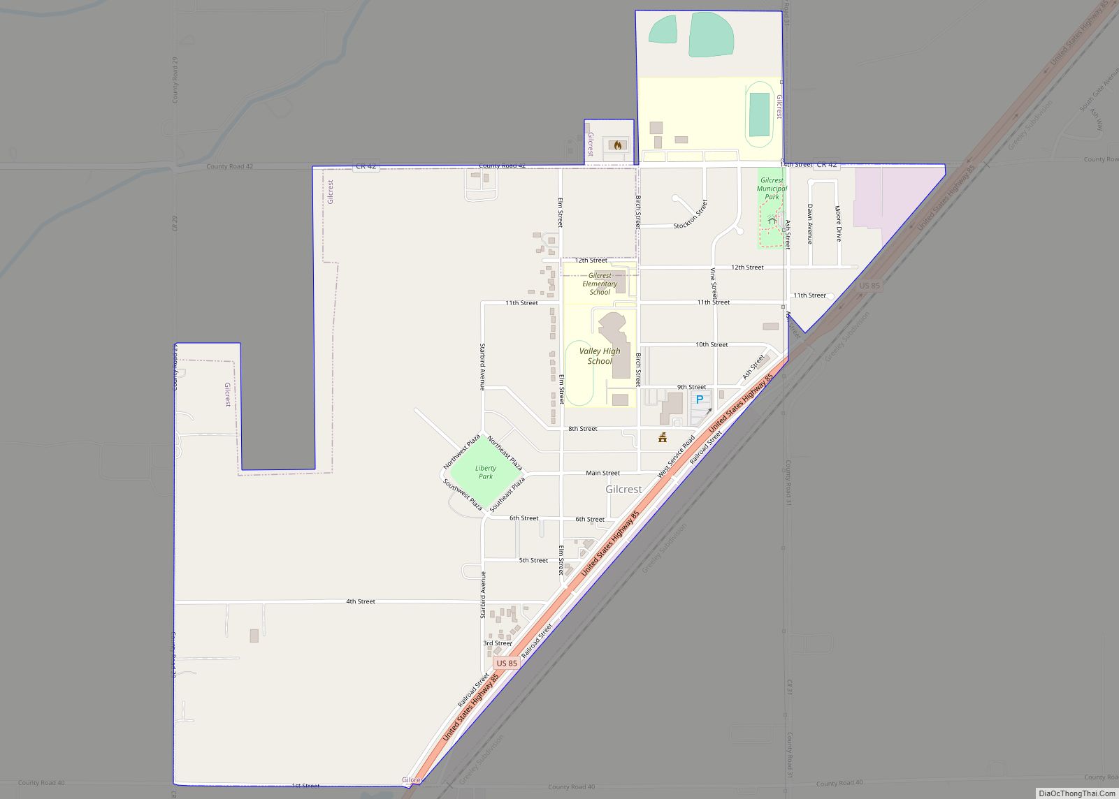
The Town of Gilcrest is a Statutory Town located in Weld County, Colorado, United States. The town population was 1,029 at the 2020 United States Census. Gilcrest is a part of the Greeley, CO Metropolitan Statistical Area and the Front Range Urban Corridor. Gilcrest town overview: Name: Gilcrest town LSAD Code: 43 LSAD Description: town ... Read more
Map of Gilcrest town
Map of Gerrard CDP
Gerrard is a census-designated place (CDP) in and governed by Rio Grande County, Colorado, United States. The population of the Gerrard CDP was 264 at the 2020 United States Census. The South Fork post office (Zip Code 81154) serves the area. Gerrard CDP overview: Name: Gerrard CDP LSAD Code: 57 LSAD Description: CDP (suffix) State: ... Read more
Map of Gerrard CDP
Map of Gold Hill CDP, Colorado
Gold Hill is an unincorporated community and a census-designated place (CDP) located in and governed by Boulder County, Colorado, United States. The CDP is a part of the Boulder, CO Metropolitan Statistical Area. The population of the Gold Hill CDP was 218 at the United States Census 2020. The Boulder post office (Zip Code 80302) ... Read more
Map of Gold Hill CDP, Colorado
Map of Glenwood Springs city
Glenwood Springs is a home rule municipality that is the county seat of Garfield County, Colorado, United States. The city population was 9,963 at the 2020 United States Census. Glenwood Springs is located at the confluence of the Roaring Fork River and the Colorado River, connecting the Roaring Fork Valley and a series of smaller ... Read more
Map of Glenwood Springs city
Map of Gleneagle CDP
Gleneagle is an unincorporated community and a census-designated place (CDP) located in and governed by El Paso County, Colorado, United States. The CDP is a part of the Colorado Springs, CO Metropolitan Statistical Area. The population of the Gleneagle CDP was 6,649 at the United States Census 2020. The Colorado Springs post office (Zip Code ... Read more
Map of Gleneagle CDP
Map of Granada town, Colorado
The Town of Granada is a Statutory Town in Prowers County, Colorado, United States. The town population was 445 at the 2020 United States Census. Granada town overview: Name: Granada town LSAD Code: 43 LSAD Description: town (suffix) State: Colorado County: Prowers County Elevation: 3,484 ft (1,062 m) Total Area: 0.685 sq mi (1.775 km²) Land Area: 0.685 sq mi (1.775 km²) Water ... Read more
Map of Granada town, Colorado
Map of Goldfield CDP, Colorado
Goldfield is an unincorporated community and a census-designated place (CDP) located in and governed by Teller County, Colorado, United States. The CDP is a part of the Colorado Springs, CO Metropolitan Statistical Area. The population of the Goldfield CDP was 63 at the United States Census 2020. The Cripple Creek post office (Zip Code 80813) ... Read more
Map of Goldfield CDP, Colorado
Map of Golden city, Colorado
Golden is a home rule city that is the county seat of Jefferson County, Colorado, United States. The city population was 20,399 at the 2020 United States Census. Golden lies along Clear Creek at the base of the Front Range of the Rocky Mountains. Founded during the Pike’s Peak Gold Rush on June 16, 1859, ... Read more
Map of Golden city, Colorado
Map of Granby town, Colorado
The Town of Granby is the Statutory Town that is the most populous municipality in Grand County, Colorado, United States. The town population was 2,079 at the 2020 United States Census. Granby is situated along U.S. Highway 40 in the Middle Park basin, and it is about 85 miles (137 km) northwest of Denver and 14 ... Read more
Map of Granby town, Colorado
Map of Grand Lake town
The Town of Grand Lake is a statutory town located in Grand County, Colorado, United States. The town population was 410 at the 2020 United States Census. Grand Lake town overview: Name: Grand Lake town LSAD Code: 43 LSAD Description: town (suffix) State: Colorado County: Grand County Elevation: 8,369 ft (2,551 m) Total Area: 1.034 sq mi (2.679 km²) Land ... Read more
Map of Grand Lake town
Map of Grand Junction city, Colorado
Grand Junction is a home rule municipality that is the county seat and the most populous municipality of Mesa County, Colorado, United States. The city population was 65,560 at the 2020 United States Census, making Grand Junction the 17th most populous Colorado municipality and the most populous city in western Colorado. Grand Junction city overview: ... Read more
Map of Grand Junction city, Colorado
Map of Greenwood Village city
The City of Greenwood Village is a home rule municipality located in Arapahoe County, Colorado, United States. The city population was 15,691 at the 2020 United States Census. Greenwood Village is a part of the Denver–Aurora–Lakewood, CO Metropolitan Statistical Area and the Front Range Urban Corridor. Greenwood Village city overview: Name: Greenwood Village city LSAD ... Read more
Map of Greenwood Village city