Map of Florida Ridge CDP
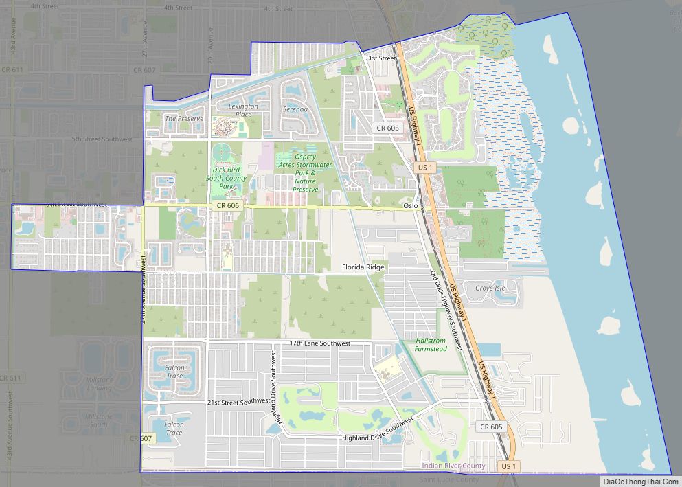
Florida Ridge is a census-designated place (CDP) in Indian River County, Florida, United States. The population was 18,164 at the 2010 census. Florida Ridge is part of the Sebastian–Vero Beach Metropolitan Statistical Area. Florida Ridge CDP overview: Name: Florida Ridge CDP LSAD Code: 57 LSAD Description: CDP (suffix) State: Florida County: Indian River County Elevation: ... Read more
Map of Florida Ridge CDP
Map of Florida City
Florida City is a city in Miami-Dade County, Florida, United States. It is the southernmost municipality in the South Florida metropolitan area. Florida City is primarily a Miami suburb and a major agricultural area. As of the 2020 census, it had a population of 13,085, up from 11,245 in 2010. The city lies to the ... Read more
Map of Florida City
Map of Fort Green Springs CDP
Fort Green Springs is an unincorporated community and census-designated place (CDP) in Hardee County, Florida, United States. Its population was 190 as of the 2020 census. Fort Green Springs CDP overview: Name: Fort Green Springs CDP LSAD Code: 57 LSAD Description: CDP (suffix) State: Florida County: Hardee County Elevation: 115 ft (35 m) Total Area: 10.37 sq mi (26.85 km²) ... Read more
Map of Fort Green Springs CDP
Map of Fort Denaud CDP
Fort Denaud is a census-designated place (CDP) and former fort in Hendry County, Florida, United States. As of the 2020 census,the population of the CDP was 2,049. Fort Denaud CDP overview: Name: Fort Denaud CDP LSAD Code: 57 LSAD Description: CDP (suffix) State: Florida County: Hendry County Elevation: 14 ft (4 m) Total Area: 20.76 sq mi (53.78 km²) Land ... Read more
Map of Fort Denaud CDP
Map of Forest City CDP, Florida
Forest City is a census-designated place and an area in Seminole County, Florida, United States. Its historic center is now in the City of Altamonte Springs. Data in this article deals only with the unincorporated section. The population was 12,612 at the 2000 census. It is part of the Orlando–Kissimmee Metropolitan Statistical Area. Forest City ... Read more
Map of Forest City CDP, Florida
Map of Fort Myers Beach town
Fort Myers Beach is a town located on the North end of Estero Island in Lee County, Florida, United States. The town is on the Gulf of Mexico and is accessed from the mainland by a bridge over Estero Bay. The population was 5,582 at the 2020 census. It is part of the Cape Coral-Fort ... Read more
Map of Fort Myers Beach town
Map of Fort Meade city, Florida
Fort Meade is a city in Polk County, Florida, United States. As of 2018, the population recorded by the U.S. Census Bureau is 6,203. It is part of the Lakeland–Winter Haven Metropolitan Statistical Area. The city was named for George Meade, at the time an Army lieutenant serving in Florida following the Second Seminole War. ... Read more
Map of Fort Meade city, Florida
Map of Fort Green CDP
Fort Green is an unincorporated community and census-designated place (CDP) in Hardee County, Florida, United States. Its population was 78 as of the 2020 census. Fort Green CDP overview: Name: Fort Green CDP LSAD Code: 57 LSAD Description: CDP (suffix) State: Florida County: Hardee County Elevation: 115 ft (35 m) Total Area: 4.04 sq mi (10.47 km²) Land Area: 4.04 sq mi ... Read more
Map of Fort Green CDP
Map of Fort Myers Shores CDP
Fort Myers Shores is an unincorporated community and census-designated place (CDP) in Lee County, Florida, United States. The population was 5,774 at the 2020 census. It is part of the Cape Coral-Fort Myers, Florida Metropolitan Statistical Area. Fort Myers Shores CDP overview: Name: Fort Myers Shores CDP LSAD Code: 57 LSAD Description: CDP (suffix) State: ... Read more
Map of Fort Myers Shores CDP
Map of Fort Pierce North CDP
Fort Pierce North is a census-designated place (CDP) in St. Lucie County, Florida, United States. Per the 2020 census, the population was 6,904. It is part of the Port St. Lucie Metropolitan Statistical Area. Fort Pierce North CDP overview: Name: Fort Pierce North CDP LSAD Code: 57 LSAD Description: CDP (suffix) State: Florida County: St. ... Read more
Map of Fort Pierce North CDP
Map of Fort Myers city
Fort Myers (or Ft. Myers) is a city in and the county seat and commercial center of Lee County, Florida, United States. The Census Bureau’s Population Estimates Program calculated that the city’s population was 92,245 in 2021, ranking the city the 370th-most-populous in the country. Together with the larger and more residential city of Cape ... Read more
Map of Fort Myers city
Map of Fort Walton Beach city
Fort Walton Beach, often referred to by the initialism FWB, a city in southern Okaloosa County, Florida. As of the 2020 U.S. census, the population was 20,922, up from 19,507 in 2010. It is the principal city of the Fort Walton Beach−Crestview−Destin Metropolitan Statistical Area. Fort Walton Beach is a year-round fishing and beach resort ... Read more
Map of Fort Walton Beach city