Map of Holly Hill city, Florida
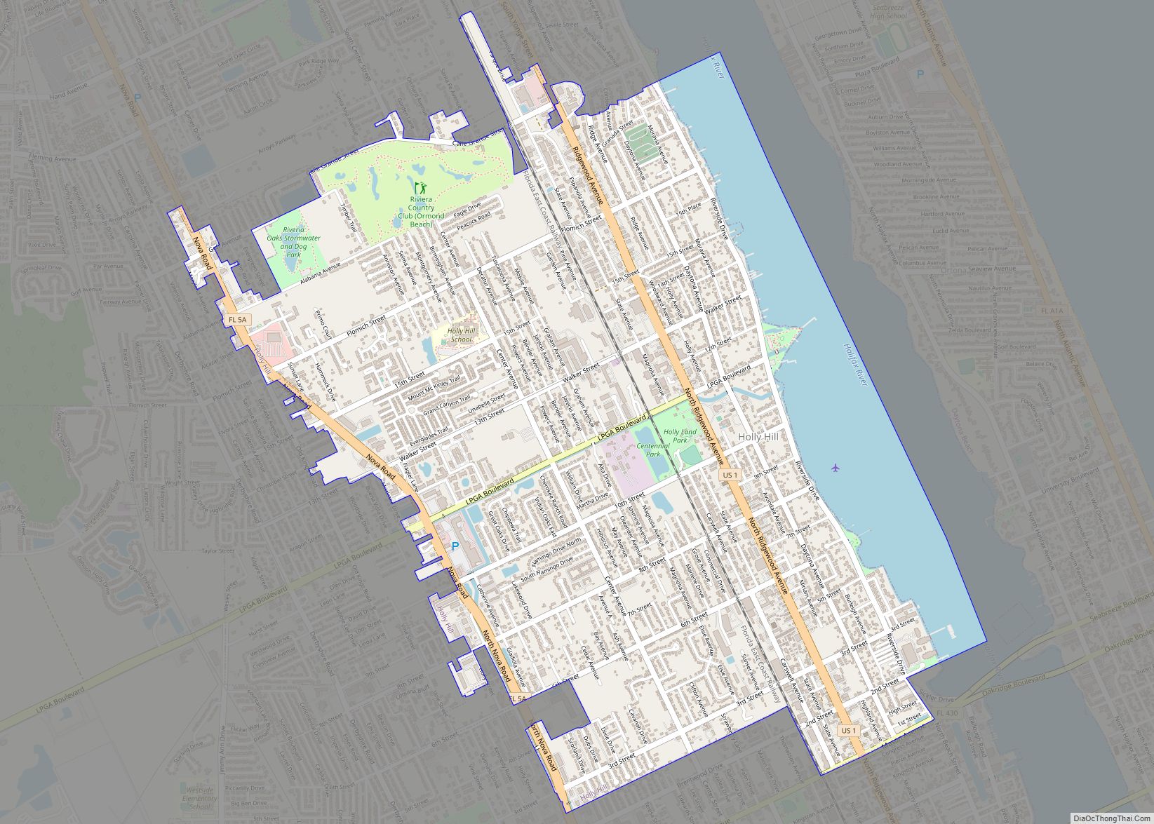
Holly Hill is a city in Volusia County, Florida, United States. The population was 11,659 at the 2010 census. Holly Hill’s city limits lie entirely on the Florida mainland, unlike the larger cities on either side of it, Daytona Beach and Ormond Beach, which encompass both the mainland and the barrier island (beach front) across ... Read more
Map of Holly Hill city, Florida
Map of Holley CDP, Florida
Holley is an unincorporated community and census-designated place in Santa Rosa County, Florida, United States. Its population was 1,630 as of the 2010 census. Florida State Road 87 passes through the community. For almost all cases, the community of Holley, is considered to be a neighborhood or character area of the larger community of Navarre, ... Read more
Map of Holley CDP, Florida
Map of Homestead city, Florida
Homestead is a city within Miami-Dade County in the U.S. state of Florida, between Biscayne National Park to the east and Everglades National Park to the west. The population was 80,737 as of the 2020 census. Homestead is primarily a Miami suburb and a major agricultural area. It is a principal city of the Miami ... Read more
Map of Homestead city, Florida
Map of Homestead Base CDP
Homestead Base is a census-designated place (CDP) in Miami-Dade County, Florida, United States. The population was 999 at the 2020 census. The CDP comprises the extent of Homestead Air Reserve Base plus some surrounding land. Homestead Base CDP overview: Name: Homestead Base CDP LSAD Code: 57 LSAD Description: CDP (suffix) State: Florida County: Miami-Dade County ... Read more
Map of Homestead Base CDP
Map of Homeland CDP, Florida
Homeland is an unincorporated community in Polk County, Florida, United States. It has a post office, a general store, and historical park. It is part of the Lakeland–Winter Haven Metropolitan Statistical Area. Homeland CDP overview: Name: Homeland CDP LSAD Code: 57 LSAD Description: CDP (suffix) State: Florida County: Polk County Elevation: 140 ft (40 m) Total Area: ... Read more
Map of Homeland CDP, Florida
Map of Horizon West CDP
Horizon West is a census-designated place and unincorporated area in Orange County, Florida, United States. The population was 14,000 at the 2010 census. It is part of the Orlando–Kissimmee–Sanford, Florida Metropolitan Statistical Area. Horizon West includes five designated mixed-use villages, namely the Village of Bridgewater, Lakeside Village, Hickory Nut, Village I and Village F., surrounded ... Read more
Map of Horizon West CDP
Map of Homosassa CDP
Homosassa is a census-designated place (CDP) in Citrus County, Florida, United States. The population was 2,578 at the 2010 census. Homosassa CDP overview: Name: Homosassa CDP LSAD Code: 57 LSAD Description: CDP (suffix) State: Florida County: Citrus County Elevation: 0 ft (0 m) Total Area: 8.33 sq mi (21.58 km²) Land Area: 7.81 sq mi (20.23 km²) Water Area: 0.52 sq mi (1.35 km²) Total Population: ... Read more
Map of Homosassa CDP
Map of Homosassa Springs CDP
Homosassa Springs is an unincorporated community and census-designated place (CDP) in Citrus County, Florida, United States. The population was 14,283 as of 2020. Homosassa Springs is the principal city of the Homosassa Springs, Florida, Metropolitan Statistical Area. The name derives from the warm spring located in Homosassa Springs Wildlife State Park that attracts manatees to ... Read more
Map of Homosassa Springs CDP
Map of Horseshoe Beach town
Horseshoe Beach is a town in Dixie County, Florida, United States. The population was 169 at the 2010 census. Horseshoe Beach town overview: Name: Horseshoe Beach town LSAD Code: 43 LSAD Description: town (suffix) State: Florida County: Dixie County Elevation: 7 ft (2 m) Total Area: 0.52 sq mi (1.34 km²) Land Area: 0.47 sq mi (1.21 km²) Water Area: 0.05 sq mi (0.12 km²) Total ... Read more
Map of Horseshoe Beach town
Map of Howey-in-the-Hills town
Howey-In-The-Hills is a town in Lake County, Florida, United States. The population was 1,098 at the 2010 census and an estimated 1,175 in 2018. It is part of the Orlando–Kissimmee–Sanford Metropolitan Statistical Area. Howey-in-the-Hills town overview: Name: Howey-in-the-Hills town LSAD Code: 43 LSAD Description: town (suffix) State: Florida County: Lake County Elevation: 89 ft (27 m) Total ... Read more
Map of Howey-in-the-Hills town
Map of Hosford CDP
Hosford is an unincorporated community and census-designated place in Liberty County, Florida, United States. Its population was 650 as of the 2010 census. It is located at the junction of State Road 20 and State Road 65. Hosford has a post office with ZIP Code 32334. It has one school, Hosford Elementary School and Jr. ... Read more
Map of Hosford CDP
Map of Hutchinson Island South CDP
Hutchinson Island South is a census-designated place (CDP) on the barrier island of Hutchinson Island in St. Lucie County, Florida, United States. The South in its name refers to its location in the southern part of St. Lucie County, as it is actually in the central part of the island as a whole. The population ... Read more
Map of Hutchinson Island South CDP