Map of Hunters Creek CDP
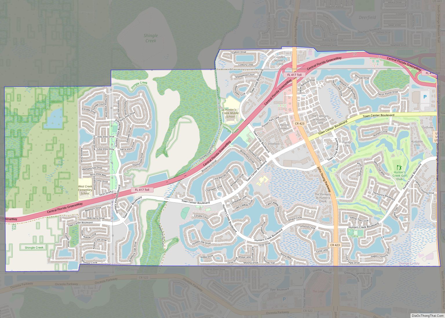
Hunter’s Creek is a master planned, unincorporated community and census-designated place in Orange County, Florida, United States. It is part of the Orlando–Kissimmee–Sanford, Florida Metropolitan Statistical Area. The population was 14,321 at the 2010 census. It has grown up around a large planned community named Hunter’s Creek, though the CDP name given by the United ... Read more
Map of Hunters Creek CDP
Map of Hudson CDP, Florida
Hudson is a census-designated place (CDP) located at the westernmost end of Pasco County, Florida, United States, and is included in the Tampa-St. Petersburg-Clearwater, Florida Metropolitan Statistical Area. As of the 2010 census, Hudson’s population was 12,158. Hudson CDP overview: Name: Hudson CDP LSAD Code: 57 LSAD Description: CDP (suffix) State: Florida County: Pasco County ... Read more
Map of Hudson CDP, Florida
Map of Indialantic town
Indialantic (officially incorporated as Indialantic-By-The-Sea, though the official name is seldom used in casual parlance) is a town in Brevard County, Florida. The town’s population was 2,720 at the 2010 United States Census. It is part of the Palm Bay–Melbourne–Titusville Metropolitan Statistical Area. The town’s name is a portmanteau derived from the town’s location between ... Read more
Map of Indialantic town
Map of Immokalee CDP
Immokalee (/ɪˈmɒk(ə)li/ ih-MOK-(ə)-lee) is an unincorporated community and census-designated place in Collier County, Florida, United States. Immokalee CDP overview: Name: Immokalee CDP LSAD Code: 57 LSAD Description: CDP (suffix) State: Florida County: Collier County Elevation: 33 ft (10 m) Total Area: 23.29 sq mi (60.32 km²) Land Area: 22.72 sq mi (58.85 km²) Water Area: 0.57 sq mi (1.48 km²)  2.5% Total Population: 24,557 Population Density: ... Read more
Map of Immokalee CDP
Map of Hypoluxo town
Hypoluxo is a town in Palm Beach County, Florida, United States. The population was 2,588 at the 2010 census. As of 2018, the population recorded by the U.S. Census Bureau was 2,783. Hypoluxo Scrub Natural Area is a protected landscape. Hypoluxo town overview: Name: Hypoluxo town LSAD Code: 43 LSAD Description: town (suffix) State: Florida ... Read more
Map of Hypoluxo town
Map of Indian River Estates CDP
Indian River Estates is a census-designated place (CDP) in St. Lucie County, Florida, United States. The population was 6,220 at the 2010 census. It is part of the Port St. Lucie Metropolitan Statistical Area. Indian River Estates CDP overview: Name: Indian River Estates CDP LSAD Code: 57 LSAD Description: CDP (suffix) State: Florida County: St. ... Read more
Map of Indian River Estates CDP
Map of Indian Harbour Beach city
Indian Harbour Beach is a coastal city in Brevard County, Florida, United States. The population was 8,225 at the 2010 United States Census. It is part of the Palm Bay–Melbourne–Titusville Metropolitan Statistical Area. It is 3 miles (4.8 km) north of the town of Indialantic and south of Satellite Beach. It is the first and only ... Read more
Map of Indian Harbour Beach city
Map of Indian Creek village, Florida
Indian Creek is a village in Miami-Dade County, Florida, United States. It has 41 residential home sites and the Indian Creek Country Club. The population was 84 at the 2020 census. Indian Creek village overview: Name: Indian Creek village LSAD Code: 47 LSAD Description: village (suffix) State: Florida County: Miami-Dade County Incorporated: May 17, 1939 ... Read more
Map of Indian Creek village, Florida
Map of Indian Shores town
Indian Shores is a town in Pinellas County, Florida, United States. The town is a beach-front community situated on a barrier island west of Seminole. The population was 1,420 at the 2010 census. Indian Shores town overview: Name: Indian Shores town LSAD Code: 43 LSAD Description: town (suffix) State: Florida County: Pinellas County Elevation: 3 ft ... Read more
Map of Indian Shores town
Map of Indian Rocks Beach city
Indian Rocks Beach, or IRB, is a city in Pinellas County, Florida, United States. The population was 4,286 at the 2018 census. Indian Rocks Beach is part of the Tampa-St. Petersburg-Clearwater, FL Metropolitan Statistical Area. Located on the barrier island Sand Key, it has over two miles of beach along the Gulf of Mexico, with ... Read more
Map of Indian Rocks Beach city
Map of Indian River Shores town
Indian River Shores is a resort town on Orchid Island, in Indian River County, Florida, United States. Surrounded by water, the town is bordered by the Indian River to the west and the Atlantic Ocean to the east. The population was 3,901 at the 2010 census, up from 3,448 at the 2000 census. It was ... Read more
Map of Indian River Shores town
Map of Indiantown village
Indiantown is a village in Martin County, Florida, United States. The population was 6,560 at the 2020 census. It is a rural community in the interior of Florida’s Treasure Coast region, first established in the early 1900s, then incorporated on December 31, 2017. The village is governed by a mayor and council elected at-large, while ... Read more
Map of Indiantown village