Map of Jacob City
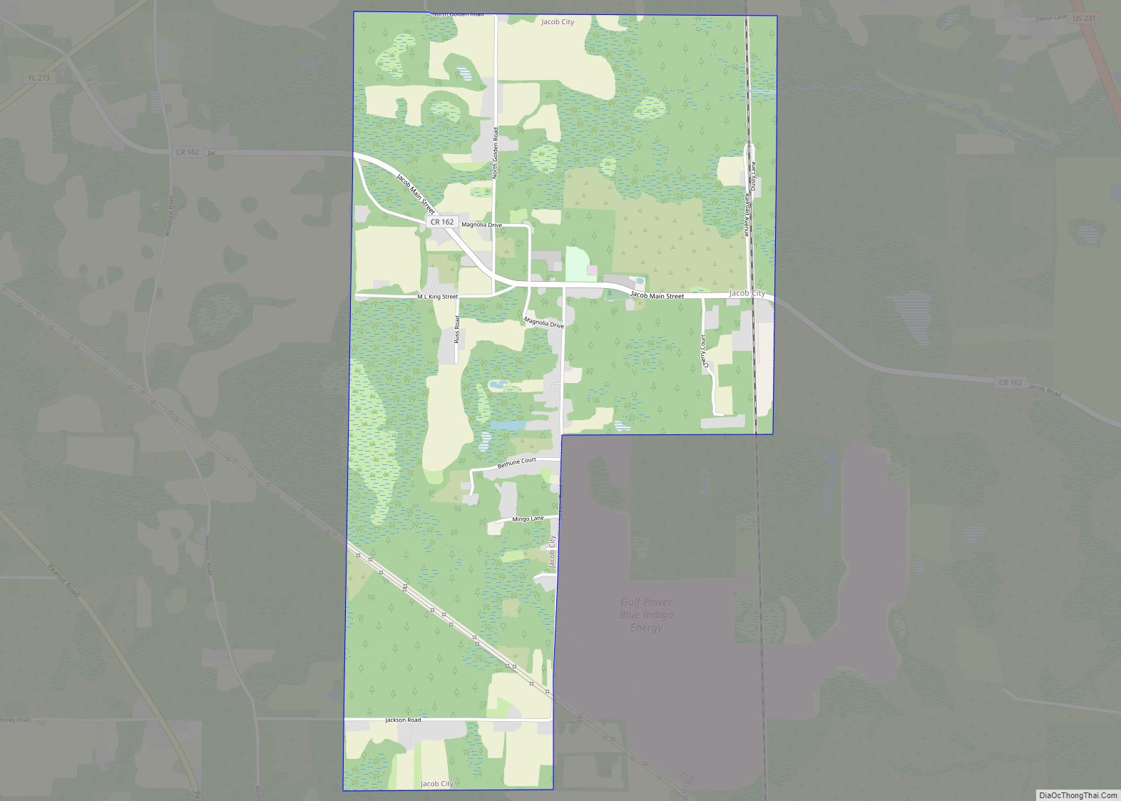
Jacob City is a city in Jackson County, Florida, United States. The population was 243 at the 2020 census. Jacob City city overview: Name: Jacob City city LSAD Code: 25 LSAD Description: city (suffix) State: Florida County: Jackson County Elevation: 135 ft (41 m) Total Area: 3.22 sq mi (8.35 km²) Land Area: 3.05 sq mi (7.89 km²) Water Area: 0.18 sq mi (0.46 km²) Total ... Read more
Map of Jacob City
Map of Jacksonville Beach city
Jacksonville Beach is a coastal resort city in Duval County, Florida, United States. It was incorporated on May 22, 1907, as Pablo Beach, and would later change its name to Jacksonville Beach in 1925. The city is part of group of communities collectively referred to as the Jacksonville Beaches. These communities include Mayport, Atlantic Beach, ... Read more
Map of Jacksonville Beach city
Map of Jay town, Florida
Jay is a town in Santa Rosa County, Florida, United States. The population was 533 at the 2010 census. As of 2018, the population estimated by the U.S. Census Bureau was 620. It is part of the Pensacola–Ferry Pass–Brent Metropolitan Statistical Area. Jay town overview: Name: Jay town LSAD Code: 43 LSAD Description: town (suffix) ... Read more
Map of Jay town, Florida
Map of Jasper city, Florida
Jasper is a city and the county seat of Hamilton County, Florida, United States. The population was 4,546 at the 2010 census, up from 1,780 at the 2000 census. The Old Hamilton County Jail and the United Methodist Church in Jasper are on the National Register of Historic Places. One of the largest industries is ... Read more
Map of Jasper city, Florida
Map of Jasmine Estates CDP
Jasmine Estates is a census-designated place (CDP) in Pasco County, Florida, United States. The population was 18,989 according to the 2010 census. Jasmine Estates CDP overview: Name: Jasmine Estates CDP LSAD Code: 57 LSAD Description: CDP (suffix) State: Florida County: Pasco County Elevation: 3 ft (1 m) Total Area: 3.68 sq mi (9.54 km²) Land Area: 3.63 sq mi (9.40 km²) Water Area: ... Read more
Map of Jasmine Estates CDP
Map of June Park CDP
June Park is a census-designated place (CDP) in Brevard County, Florida. The population was 4,094 at the 2010 United States Census. It is part of the Palm Bay–Melbourne–Titusville Metropolitan Statistical Area. June Park CDP overview: Name: June Park CDP LSAD Code: 57 LSAD Description: CDP (suffix) State: Florida County: Brevard County Elevation: 26 ft (8 m) Total ... Read more
Map of June Park CDP
Map of Jensen Beach CDP
Jensen Beach is an unincorporated community and census-designated place (CDP) in Martin County, Florida, United States. The population was 12,652 at the 2020 census. It is part of the Port St. Lucie, Florida Metropolitan Statistical Area. Jensen Beach CDP overview: Name: Jensen Beach CDP LSAD Code: 57 LSAD Description: CDP (suffix) State: Florida County: Martin ... Read more
Map of Jensen Beach CDP
Map of Jennings town, Florida
Jennings is a town in Hamilton County, Florida, United States. The population was 878 at the 2010 census, up from 833 at the 2000 census. Actor Andrew Prine was born here. Jennings town overview: Name: Jennings town LSAD Code: 43 LSAD Description: town (suffix) State: Florida County: Hamilton County Elevation: 141 ft (43 m) Total Area: 2.91 sq mi ... Read more
Map of Jennings town, Florida
Map of Juno Ridge CDP
Juno Ridge is a census-designated place (CDP) in Palm Beach County, Florida, United States. The population was 742 at the 2000 census. Juno Ridge CDP overview: Name: Juno Ridge CDP LSAD Code: 57 LSAD Description: CDP (suffix) State: Florida County: Palm Beach County Elevation: 13 ft (4 m) Total Area: 0.23 sq mi (0.59 km²) Land Area: 0.21 sq mi (0.55 km²) Water ... Read more
Map of Juno Ridge CDP
Map of Juno Beach town
Juno Beach is a town in Palm Beach County, Florida, United States. Its population was 3,176 at the 2010 census. As of 2018, the population recorded by the U.S. Census Bureau was estimated at 3,648. Juno Beach is home to the headquarters of Florida Power & Light, the Loggerhead Marinelife Center and the Seminole Golf ... Read more
Map of Juno Beach town
Map of Jupiter Farms CDP
Jupiter Farms is a community in Palm Beach County, Florida, United States. Jupiter Farms, locally known as “The Farms”, is located west of Florida’s Turnpike on Indiantown Road (County Road 706), the major highway through the community. The exact population is unknown. In 2010 the population was approximately 12,000. “The Farms” is composed of roughly ... Read more
Map of Jupiter Farms CDP
Map of Jupiter town
Jupiter is the northernmost town in Palm Beach County, Florida, United States. According to the 2020 Census, the town had a population of 61,047 as of April 1, 2020. It is 84 miles north of Miami and 15 miles north of West Palm Beach, Jupiter is the northernmost community in the Miami metropolitan area, home ... Read more
Map of Jupiter town