Map of Macclenny city
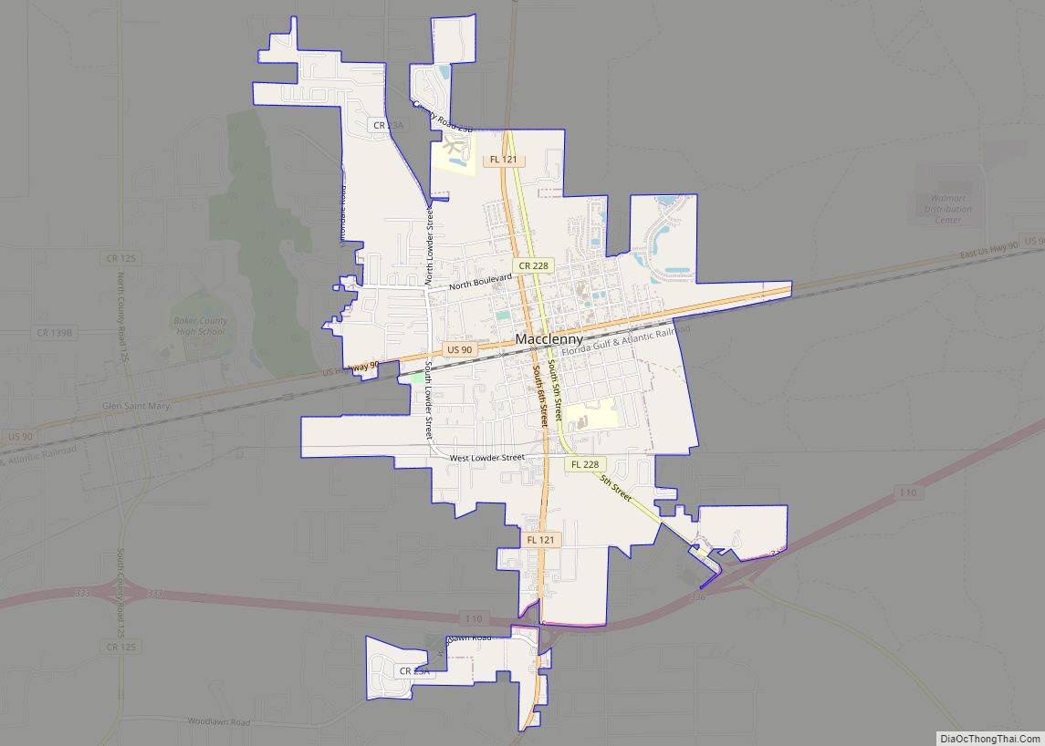
Macclenny is a city and the county seat of Baker County, Florida. Located just west of Jacksonville, it is one of the principal municipalities comprising Greater Jacksonville. The population was 7,304 at the 2020 census, up from 6,374 in 2010. Macclenny city overview: Name: Macclenny city LSAD Code: 25 LSAD Description: city (suffix) State: Florida ... Read more
Map of Macclenny city
Map of Lynn Haven city
Lynn Haven is a city in Bay County, Florida, United States, north of Panama City. The population was 18,493 at the 2010 census. Like many communities in Bay County, the city was severely damaged by Category 5 Hurricane Michael on October 10, 2018. Lynn Haven city overview: Name: Lynn Haven city LSAD Code: 25 LSAD ... Read more
Map of Lynn Haven city
Map of Malabar town
Malabar is a town in Brevard County, Florida. The population was 2,757 at the 2010 United States Census. It is part of the Palm Bay–Melbourne–Titusville Metropolitan Statistical Area. Malabar town overview: Name: Malabar town LSAD Code: 43 LSAD Description: town (suffix) State: Florida County: Brevard County Elevation: 23 ft (7 m) Total Area: 13.27 sq mi (34.36 km²) Land Area: ... Read more
Map of Malabar town
Map of Maitland city, Florida
Maitland is a suburban city in Orange County, Florida, United States, part of the Greater Orlando area. The population was 19,543 at the 2020 census. The area’s history is exhibited at the Maitland Historical Museum; the city also hosts the Maitland Art Center, as well as notable examples of Mayan Revival architecture and Fantasy architecture, ... Read more
Map of Maitland city, Florida
Map of Madison city, Florida
Madison is a city in and the county seat of Madison County, on the central northern border of Florida, United States. The population was 2,912 at the 2020 census. Madison city overview: Name: Madison city LSAD Code: 25 LSAD Description: city (suffix) State: Florida County: Madison County Elevation: 190 ft (60 m) Total Area: 2.69 sq mi (7.0 km²) Land ... Read more
Map of Madison city, Florida
Map of Manasota Key CDP
Manasota Key is a census-designated place (CDP) consisting mainly of the community of Englewood Beach in Charlotte County, Florida, United States. The population of the CDP was 1,326 at the 2020 census. It is part of the Sarasota-Bradenton-Punta Gorda Combined Statistical Area. Manasota Key CDP overview: Name: Manasota Key CDP LSAD Code: 57 LSAD Description: ... Read more
Map of Manasota Key CDP
Map of Manalapan town
Manalapan is a town in Palm Beach County, Florida, United States. The population was 419 at the 2020 United States census. Manalapan town overview: Name: Manalapan town LSAD Code: 43 LSAD Description: town (suffix) State: Florida County: Palm Beach County Elevation: 3 ft (1 m) Total Area: 10.52 sq mi (27.25 km²) Land Area: 0.45 sq mi (1.16 km²) Water Area: 10.07 sq mi (26.09 km²) ... Read more
Map of Manalapan town
Map of Malone town, Florida
Malone is a town in Jackson County, Florida, United States. The population was 2,088 at the 2010 census. Malone town overview: Name: Malone town LSAD Code: 43 LSAD Description: town (suffix) State: Florida County: Jackson County Elevation: 141 ft (43 m) Total Area: 3.05 sq mi (7.90 km²) Land Area: 3.05 sq mi (7.90 km²) Water Area: 0.00 sq mi (0.00 km²) Total Population: 1,959 Population ... Read more
Map of Malone town, Florida
Map of Mango CDP
Mango is a census-designated place (CDP) in Hillsborough County, Florida, United States. The population was 11,313 at the 2010 census, up from 8,842 at the 2000 census. Mango CDP overview: Name: Mango CDP LSAD Code: 57 LSAD Description: CDP (suffix) State: Florida County: Hillsborough County Elevation: 52 ft (16 m) Total Area: 4.81 sq mi (12.46 km²) Land Area: 4.67 sq mi ... Read more
Map of Mango CDP
Map of Manatee Road CDP
Manatee Road is a census-designated place (CDP) in Levy County, Florida, United States. The population was 2,244 at the 2010 census. At the 2000 census, the CDP was misspelled as “Manattee Road”. Manatee Road CDP overview: Name: Manatee Road CDP LSAD Code: 57 LSAD Description: CDP (suffix) State: Florida County: Levy County Elevation: 30 ft (9 m) ... Read more
Map of Manatee Road CDP
Map of Mangonia Park town
Mangonia Park is a town in Palm Beach County, Florida, United States. It is a part of Uptown West Palm, which also includes Riviera Beach and West Palm Beach. The population was 1,888 at the 2010 census. As of 2018, the population recorded by the U.S. Census Bureau was 2,017. Mangonia Park town overview: Name: ... Read more
Map of Mangonia Park town
Map of Margate city
Margate is a city in Broward County, Florida, United States. As of the 2020 census, the city had a population of 58,712. Margate is part of the Miami metropolitan area, which was home to 6,166,488 people in 2020. Margate was founded in the 1950s, when much of it was still either part of the Everglades ... Read more
Map of Margate city