Map of Ponce de Leon town
Ponce de Leon (/ˌpɒns də ˈliːən/ PONSS də LEE-ən) is a town in Holmes County, Florida, United States. The population was 598 at the 2010 census, up from 457 at the 2000 census. From 2000 to 2010, the Ponce de Leon town population growth percentage was 30.9%. Ponce de Leon town overview: Name: Ponce de ... Read more
Map of Ponce de Leon town
Map of Pomona Park town
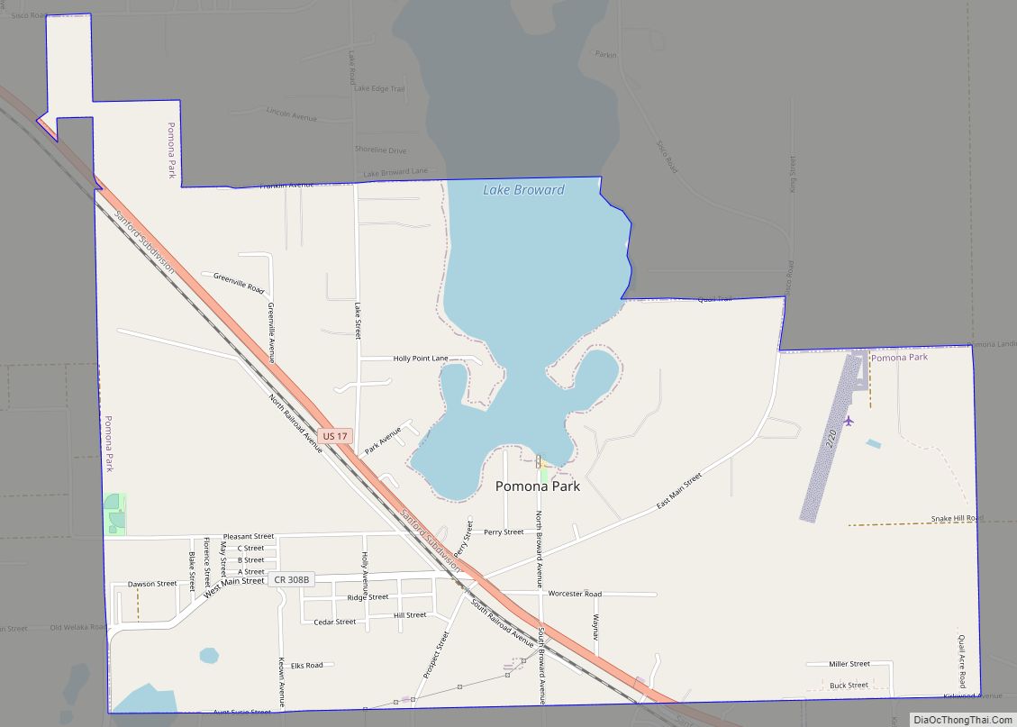
Pomona Park is a town in Putnam County, Florida, United States. The population was 912 at the 2010 census and has gone up to 916 in the 2018 estimates. The town is part of the Palatka Micropolitan Statistical Area. Pomona Park town overview: Name: Pomona Park town LSAD Code: 43 LSAD Description: town (suffix) State: ... Read more
Map of Pomona Park town
Map of Port LaBelle CDP
Port LaBelle is a census-designated place (CDP) in Hendry and Glades counties, Florida, United States. The population was 3,530 at the 2010 census, up from 3,050 at the 2000 census. Port LaBelle CDP overview: Name: Port LaBelle CDP LSAD Code: 57 LSAD Description: CDP (suffix) State: Florida County: Hendry County Elevation: 10 ft (3 m) Total Area: ... Read more
Map of Port LaBelle CDP
Map of Port Charlotte CDP
Port Charlotte is an unincorporated community and census-designated place (CDP) in Charlotte County, Florida, United States. The population was 60,625 at the 2020 census. It is part of the Sarasota-Bradenton-Punta Gorda Combined Statistical Area. Port Charlotte was named to the “10 Best Places to Retire”, in the United States for the year 2012 by U.S. ... Read more
Map of Port Charlotte CDP
Map of Ponce Inlet town
Ponce Inlet is a town in Volusia County, Florida, United States. The population was 3,032 at the 2010 census. The town of Ponce Inlet is located on the southern tip of a barrier island, south of Daytona Beach and Daytona Beach Shores. Several marinas are located in Ponce Inlet. The community is known for its ... Read more
Map of Ponce Inlet town
Map of Port Salerno CDP
Port Salerno is an unincorporated community and census-designated place (CDP) in Martin County, Florida, United States. The population was 10,401 at the 2020 census. It is part of the Port St. Lucie Metropolitan Statistical Area. Port Salerno CDP overview: Name: Port Salerno CDP LSAD Code: 57 LSAD Description: CDP (suffix) State: Florida County: Martin County ... Read more
Map of Port Salerno CDP
Map of Port Richey city
Port Richey is a city in Pasco County, Florida, United States. It is a suburban city included in the Tampa-St. Petersburg-Clearwater, Florida Metropolitan Statistical Area. Port Richey city overview: Name: Port Richey city LSAD Code: 25 LSAD Description: city (suffix) State: Florida County: Pasco County Elevation: 10 ft (3 m) Total Area: 2.28 sq mi (5.90 km²) Land Area: 2.22 sq mi ... Read more
Map of Port Richey city
Map of Port Orange city
Port Orange is a city in Volusia County, Florida. The city’s population was estimated at 64,842 in 2019 by the U.S. Census Bureau. The city is part of the Deltona–Daytona Beach–Ormond Beach metropolitan area; the metropolitan area’s population in 2010 was 590,289. Port Orange is a principal city in the Fun Coast region of the ... Read more
Map of Port Orange city
Map of Pretty Bayou CDP
Pretty Bayou is a census-designated place (CDP) in Bay County, Florida, United States. The population was 3,206 at the 2010 census. It is part of the Panama City–Lynn Haven–Panama City Beach Metropolitan Statistical Area. In 2018, Hurricane Michael caused significant damage to the city. Pretty Bayou CDP overview: Name: Pretty Bayou CDP LSAD Code: 57 ... Read more
Map of Pretty Bayou CDP
Map of Port St. John CDP
Port St. John is a census-designated place located between Titusville and Cocoa in Brevard County, Florida. The population was 12,267 at the 2010 United States Census. It is part of the Palm Bay–Melbourne–Titusville Metropolitan Statistical Area. Port St. John CDP overview: Name: Port St. John CDP LSAD Code: 57 LSAD Description: CDP (suffix) State: Florida ... Read more
Map of Port St. John CDP
Map of Port St. Joe city
Port St. Joe is a city and the county seat of Gulf County, Florida. It is located at the intersection of U.S. Highway 98 and State Road 71 As of the 2020 census,the population was 3,357, a decline from 3,644 as of the 2000 census. Port St. Joe city overview: Name: Port St. Joe city ... Read more
Map of Port St. Joe city
Map of Punta Gorda city
Punta Gorda (/ˌpʌntə ˈɡɔːrdə/; English: Fat Point) is a city located in Southwest Florida and is the county seat of Charlotte County, Florida, United States. As of the 2020 U.S. Census the city had a population of 19,471. Punta Gorda is part of the Sarasota-Bradenton-Punta Gorda Combined Statistical Area. Punta Gorda was the scene of ... Read more
Map of Punta Gorda city