Map of Swartz CDP
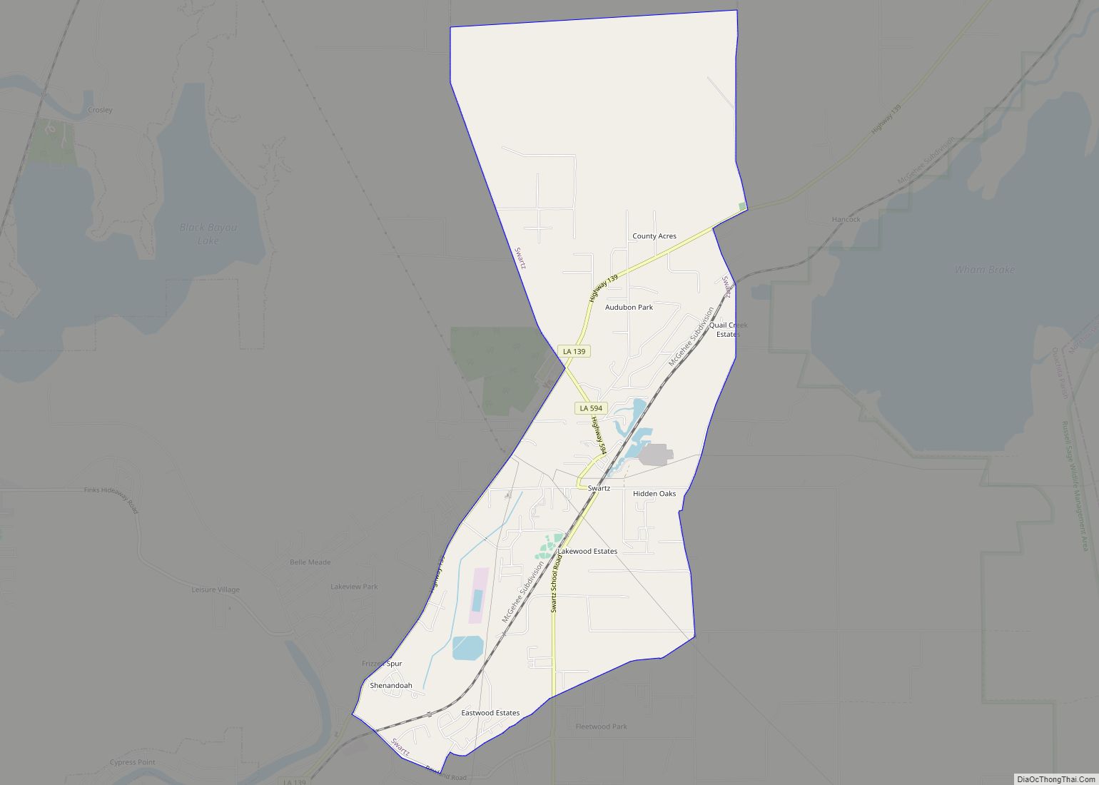
Swartz is a census-designated place (CDP) in Ouachita Parish in northeastern Louisiana, United States. The population was 4,536 in the 2010 census, an increase of 289 or 6.8 percent over the 2000 population. It is part of the Monroe Metropolitan Statistical Area. Swartz CDP overview: Name: Swartz CDP LSAD Code: 57 LSAD Description: CDP (suffix) ... Read more
Map of Swartz CDP
Map of Tangipahoa village
Tangipahoa is a village in Tangipahoa Parish, Louisiana, United States. The population was 425 at the 2020 census. It was named after the Tangipahoa Native American tribe. Tangipahoa is part of the Hammond Micropolitan Statistical Area. Tangipahoa village overview: Name: Tangipahoa village LSAD Code: 47 LSAD Description: village (suffix) State: Louisiana County: Tangipahoa Parish Founded: ... Read more
Map of Tangipahoa village
Map of Tallulah city
Tallulah /təˈluːlə/ is a city in and the parish seat of Madison Parish in northeastern Louisiana, United States. The 2010 population was 7,335, a decrease of 1,854, or 20.2 percent, from the 9,189 recorded at the 2000 census. As this was historically a center of agriculture since the antebellum years, producing cotton and pecans, Tallulah ... Read more
Map of Tallulah city
Map of Taft CDP, Louisiana
Taft was a census-designated place (CDP) in St. Charles Parish, Louisiana, United States, located on the west bank of the Mississippi River. According to the 2000 census, Taft had a total population of zero. Taft CDP overview: Name: Taft CDP LSAD Code: 57 LSAD Description: CDP (suffix) State: Louisiana County: St. Charles Parish Elevation: 13 ft ... Read more
Map of Taft CDP, Louisiana
Map of Tickfaw village
Tickfaw was founded in 1852 and is a village in Tangipahoa Parish, Louisiana, United States. The population was 694 at the 2010 census. Tickfaw is part of the Hammond Micropolitan Statistical Area. It was originally inhabited by Italian-American immigrants and continues to have a distinct Italian-American heritage. Tickfaw village overview: Name: Tickfaw village LSAD Code: ... Read more
Map of Tickfaw village
Map of Thibodaux city
Thibodaux (/ˈtɪbədoʊ/ TIB-ə-doh) is a city in, and the parish seat of, Lafourche Parish, Louisiana, United States, along the banks of Bayou Lafourche in the northwestern part of the parish. The population was 15,948 at the 2020 census. Thibodaux is a principal city of the Houma–Bayou Cane–Thibodaux metropolitan statistical area. Thibodaux is nicknamed the “Queen ... Read more
Map of Thibodaux city
Map of Terrytown CDP, Louisiana
Terrytown is an unincorporated community and census-designated place (CDP) in Jefferson Parish, Louisiana, United States. It is on the “Westbank” (to the south) of the Mississippi River. It is a suburb within the New Orleans–Metairie–Kenner metropolitan statistical area. The population was 23,319 at the 2010 census, and 25,278 in 2020. Terrytown was opened to a ... Read more
Map of Terrytown CDP, Louisiana
Map of Tullos town
Tullos is a town in LaSalle and Winn parishes in the U.S. state of Louisiana, along Castor Creek. The population was 385 at the 2010 census. Tullos town overview: Name: Tullos town LSAD Code: 43 LSAD Description: town (suffix) State: Louisiana County: LaSalle Parish, Winn Parish Elevation: 125 ft (38 m) Total Area: 1.60 sq mi (4.16 km²) Land Area: ... Read more
Map of Tullos town
Map of Triumph CDP
Triumph (French: Ville de Triomphe) is an unincorporated community and census-designated place in Plaquemines Parish, Louisiana, United States. It is located on the south bank of the Mississippi River. As of the 2020 census, its population was 268. It is the closest town to two National Historic Landmarks: Fort Jackson (down river from the town; ... Read more
Map of Triumph CDP
Map of Timberlane CDP, Louisiana
Timberlane is a census-designated place (CDP) in Jefferson Parish, Louisiana, United States. The population was 10,364 in 2020. It is part of the New Orleans–Metairie–Kenner metropolitan statistical area. Timberlane CDP overview: Name: Timberlane CDP LSAD Code: 57 LSAD Description: CDP (suffix) State: Louisiana County: Jefferson Parish Total Area: 1.50 sq mi (3.89 km²) Land Area: 1.50 sq mi (3.89 km²) Water ... Read more
Map of Timberlane CDP, Louisiana
Map of Urania town
Urania is a town in La Salle Parish, Louisiana United States. The population was 1,313 at the 2010 census. The late state Representative Thomas “Bud” Brady was born in Urania in 1938. Urania town overview: Name: Urania town LSAD Code: 43 LSAD Description: town (suffix) State: Louisiana County: LaSalle Parish Elevation: 92 ft (28 m) Total Area: ... Read more
Map of Urania town
Map of Union CDP, Louisiana
Union is an unincorporated community and census-designated place in St. James Parish, Louisiana, United States. Its population was 892 as of the 2010 census. The community is located along Louisiana Highway 44 on the east bank of the Mississippi River. Union CDP overview: Name: Union CDP LSAD Code: 57 LSAD Description: CDP (suffix) State: Louisiana ... Read more
Map of Union CDP, Louisiana