Map of St. Joseph town, Louisiana
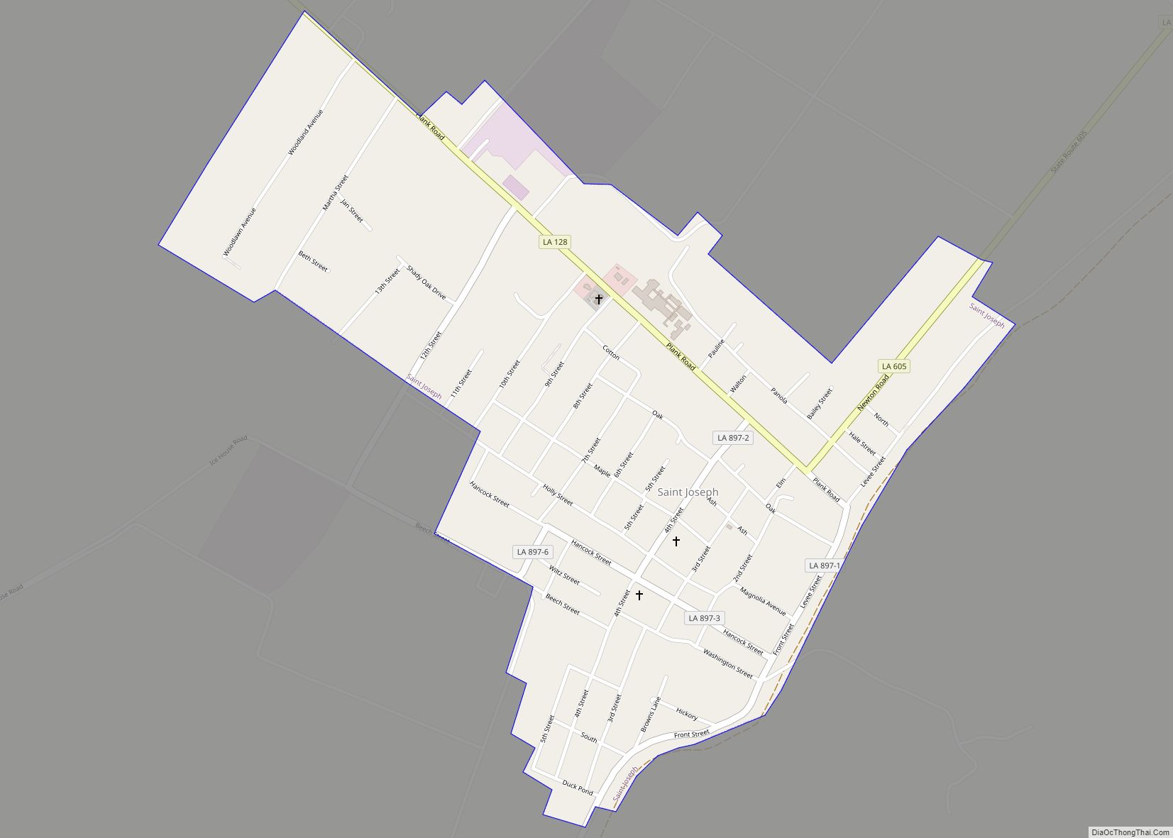
St. Joseph, often called St. Joe, is a town in, and the parish seat of, rural Tensas Parish in northeastern Louisiana, United States, in the delta of the Mississippi River. The population was 1,176 at the 2010 census. The town had an African-American majority of 77.4 percent in 2010. St. Joseph town overview: Name: St. ... Read more
Map of St. Joseph town, Louisiana
Map of Starks CDP
Starks is an unincorporated community and census-designated place (CDP) in Calcasieu Parish, Louisiana, United States. As of the 2010 census it had a population of 664. It is located approximately 30 miles (48 km) northwest of Lake Charles and about 5 miles (8 km) from the Texas and Louisiana border. Starks is known for its annual Mayhaw ... Read more
Map of Starks CDP
Map of Stanley village, Louisiana
Stanley is a village in DeSoto Parish, Louisiana, United States. The population was 107 at the 2010 census, down from 145 in 2000. It is part of the Shreveport–Bossier City Metropolitan Statistical Area. Stanley village overview: Name: Stanley village LSAD Code: 47 LSAD Description: village (suffix) State: Louisiana County: De Soto Parish Elevation: 312 ft (95 m) ... Read more
Map of Stanley village, Louisiana
Map of St. Rose CDP, Louisiana
Saint Rose (usually written as St. Rose) is a census-designated place (CDP) in St. Charles Parish, Louisiana, United States. St. Rose is on the east bank of the Mississippi River, two miles (3 km) north of the Jefferson Parish border and is part of the Greater New Orleans metropolitan area. The population was 6,540 in ... Read more
Map of St. Rose CDP, Louisiana
Map of Stonewall town, Louisiana
Stonewall is a town in northern DeSoto Parish, Louisiana, United States. The population was 1,814 at the 2010 census, increasing to 2,273 in 2020. It is part of the Shreveport–Bossier City metropolitan statistical area. North DeSoto High School and the Garland Scout Ranch of the Boy Scouts of America are located in Stonewall. Stonewall town ... Read more
Map of Stonewall town, Louisiana
Map of Sterlington town
Sterlington is a town in northern Ouachita Parish, Louisiana, United States, near the boundary with Union Parish. At the 2010 census, the population was 1,594. In the 2018 census estimates, the population rose to 2,724. In 2014, Sterlington was the fastest-growing community in Northeast Louisiana. Sterlington town overview: Name: Sterlington town LSAD Code: 43 LSAD ... Read more
Map of Sterlington town
Map of Start CDP
Start is an unincorporated community and census-designated place in Richland Parish, Louisiana, United States. In 2010, it was named as a census-designated place with a population of 905. On September 8, 2018, Start held a community wide celebration in recognition of its centennial year as the named place of Start. Start CDP overview: Name: Start ... Read more
Map of Start CDP
Map of Sun village
Sun is a village in the northeastern corner of St. Tammany Parish, Louisiana, United States. The population was 470 at the 2010 census. It is part of the New Orleans–Metairie–Kenner Metropolitan Statistical Area. Sun village overview: Name: Sun village LSAD Code: 47 LSAD Description: village (suffix) State: Louisiana County: St. Tammany Parish Elevation: 69 ft (21 m) ... Read more
Map of Sun village
Map of Sulphur city, Louisiana
Sulphur (French: Soufre) is a city in Calcasieu Parish, Louisiana, United States. The population was 21,809 in 2020. Sulphur is part of the Lake Charles metropolitan statistical area. Sulphur city overview: Name: Sulphur city LSAD Code: 25 LSAD Description: city (suffix) State: Louisiana County: Calcasieu Parish Elevation: 16 ft (5 m) Total Area: 11.24 sq mi (29.10 km²) Land Area: ... Read more
Map of Sulphur city, Louisiana
Map of Sugartown CDP
Sugartown is an unincorporated community and census-designated place in Beauregard Parish, Louisiana, United States, approximately 16 miles (26 km) east of DeRidder. As of the 2010 census it had a population of 54. The geographical center of Sugartown today is posted as the intersection of LA 112 and LA 113. The original community was much larger. ... Read more
Map of Sugartown CDP
Map of Supreme CDP
Supreme is a census-designated place (CDP) in Assumption Parish, Louisiana, United States. The population was 1,052 at the 2010 census. Supreme CDP overview: Name: Supreme CDP LSAD Code: 57 LSAD Description: CDP (suffix) State: Louisiana County: Assumption Parish Elevation: 16 ft (5 m) Total Area: 3.43 sq mi (8.90 km²) Land Area: 3.38 sq mi (8.77 km²) Water Area: 0.05 sq mi (0.13 km²) Total Population: ... Read more
Map of Supreme CDP
Map of Sunset town, Louisiana
Sunset is a town in St. Landry Parish, Louisiana, United States. The population was 2,897 at the 2010 census, up from 2,352 in 2000. It is part of the Opelousas–Eunice Micropolitan Statistical Area. Sunset town overview: Name: Sunset town LSAD Code: 43 LSAD Description: town (suffix) State: Louisiana County: St. Landry Parish Founded: 1904 Elevation: ... Read more
Map of Sunset town, Louisiana