Map of Aliquippa city
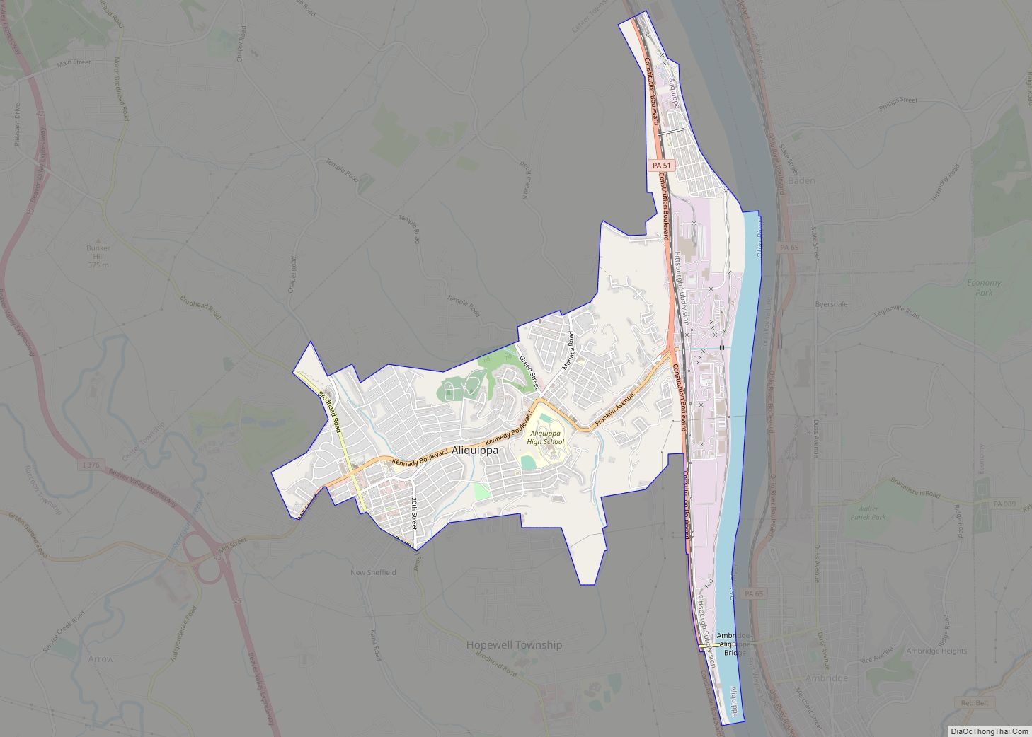
Aliquippa is the largest city in Beaver County, Pennsylvania, United States, located on the Ohio River about 18 miles (29 km) northwest of Pittsburgh. The population was 9,238 at the 2020 census. It is part of the Pittsburgh metropolitan area. Formerly the location of a large Native American trading center, Aliquippa grew to become a center ... Read more
Map of Aliquippa city
Map of Alfarata CDP
Alfarata is a census-designated place located in Decatur Township, Mifflin County in the state of Pennsylvania, United States. It is located along U.S. Route 522 in eastern Mifflin County. As of the 2010 census, the population was 149 residents. The community was named for the Indian girl Alfarata from the song “The Blue Juniata”. Alfarata ... Read more
Map of Alfarata CDP
Map of Alexandria borough, Pennsylvania
Alexandria is a borough in Huntingdon County, Pennsylvania, United States. The population was 388 at the 2020 census. Alexandria borough overview: Name: Alexandria borough LSAD Code: 21 LSAD Description: borough (suffix) State: Pennsylvania County: Huntingdon County Elevation: 699 ft (213 m) Total Area: 0.11 sq mi (0.29 km²) Land Area: 0.11 sq mi (0.29 km²) Water Area: 0.00 sq mi (0.00 km²) Total Population: 384 Population ... Read more
Map of Alexandria borough, Pennsylvania
Map of Aldan borough
Aldan is a borough in Delaware County, Pennsylvania, United States. The population was 4,152 at the 2010 census. Aldan borough overview: Name: Aldan borough LSAD Code: 21 LSAD Description: borough (suffix) State: Pennsylvania County: Delaware County Elevation: 128 ft (39 m) Total Area: 0.60 sq mi (1.55 km²) Land Area: 0.60 sq mi (1.55 km²) Water Area: 0.00 sq mi (0.00 km²) Total Population: 4,244 Population ... Read more
Map of Aldan borough
Map of Alburtis borough
Alburtis is a borough in Lehigh County, Pennsylvania. The borough’s population was 2,596 as of the 2020 census. It is a suburb of Allentown, the third largest city in Pennsylvania. It is part of the Lehigh Valley metropolitan area, which had a population of 861,899 and was the 68th-most populous metropolitan area in the U.S. ... Read more
Map of Alburtis borough
Map of Albrightsville CDP
Albrightsville is an unincorporated community and census-designated place which is located in Kidder and Penn Forest townships, Carbon County, Pennsylvania, United States. It is part of Northeastern Pennsylvania. Albrightsville CDP overview: Name: Albrightsville CDP LSAD Code: 57 LSAD Description: CDP (suffix) State: Pennsylvania County: Carbon County Elevation: 1,510 ft (460 m) Total Area: 1.01 sq mi (2.61 km²) Land Area: ... Read more
Map of Albrightsville CDP
Map of Albion borough, Pennsylvania
Albion is a borough in Erie County, Pennsylvania, United States. The population was 1,516 at the 2010 census. It is part of the Erie Metropolitan Statistical Area. One of their main industries is the Albion State Correctional Institute (SCI Albion). The town was ravaged by an F4 tornado that was part of the 1985 United ... Read more
Map of Albion borough, Pennsylvania
Map of Alba borough, Pennsylvania
Alba borough overview: Name: Alba borough LSAD Code: 21 LSAD Description: borough (suffix) State: Pennsylvania County: Bradford County FIPS code: 4200572 Online Interactive Map Alba online map. Source: Basemap layers from Google Map, Open Street Map (OSM), Arcgisonline, Wmflabs. Boundary Data from Database of Global Administrative Areas. Alba location map. Where is Alba borough? Alba ... Read more
Map of Alba borough, Pennsylvania
Map of Akron borough, Pennsylvania
Akron is a borough in Lancaster County, Pennsylvania, United States. As of the 2020 census, it had a population of 4,169, Akron borough overview: Name: Akron borough LSAD Code: 21 LSAD Description: borough (suffix) State: Pennsylvania County: Lancaster County Elevation: 509 ft (155 m) Total Area: 1.23 sq mi (3.19 km²) Land Area: 1.23 sq mi (3.18 km²) Water Area: 0.01 sq mi (0.02 km²) Total ... Read more
Map of Akron borough, Pennsylvania
Map of Addison borough, Pennsylvania
Addison is a borough in Somerset County, Pennsylvania, United States. It is part of the Johnstown, Pennsylvania, Metropolitan Statistical Area. The population was 165 at the 2020 census. Addison borough overview: Name: Addison borough LSAD Code: 21 LSAD Description: borough (suffix) State: Pennsylvania County: Somerset County Incorporated: February 28, 1912 Total Area: 0.54 sq mi (1.41 km²) Land ... Read more
Map of Addison borough, Pennsylvania
Map of Allison CDP, Pennsylvania
Allison is an unincorporated community and census-designated place (CDP), which is located in Luzerne and Redstone townships in Fayette County, Pennsylvania, United States. It is situated 3 miles (5 km) south of the borough of Brownsville. As of the 2010 census, the population was 625. The CDP includes the neighborhood of Allison Heights in Luzerne Township. ... Read more
Map of Allison CDP, Pennsylvania
Map of Allison Park CDP
Allison Park is a census-designated place in Allegheny County, Pennsylvania, United States. It is a suburb of Pittsburgh and is located within Hampton, McCandless, Shaler, Indiana and West Deer townships. It had a population of 21,864 at the 2020 census. The ZIP Code for Allison Park is 15101. Allison Park CDP overview: Name: Allison Park ... Read more
Map of Allison Park CDP