Map of Dry Tavern CDP
Dry Tavern is a census-designated place in Jefferson Township, Greene County, Pennsylvania, United States. It is located next to the borough of Rices Landing along Pennsylvania Route 88, on high ground south of the Monongahela River. As of the 2010 census the population was 697. Dry Tavern CDP overview: Name: Dry Tavern CDP LSAD Code: ... Read more
Map of Dry Tavern CDP
Map of Driftwood borough, Pennsylvania
Driftwood is a borough in Cameron County, Pennsylvania, United States. The population was 36 at the 2020 census. Driftwood borough overview: Name: Driftwood borough LSAD Code: 21 LSAD Description: borough (suffix) State: Pennsylvania County: Cameron County Elevation: 850 ft (260 m) Total Area: 2.56 sq mi (6.62 km²) Land Area: 2.49 sq mi (6.45 km²) Water Area: 0.07 sq mi (0.18 km²) Total Population: 38 Population ... Read more
Map of Driftwood borough, Pennsylvania
Map of Drexel Hill CDP
Drexel Hill is a neighborhood and census-designated place (CDP) located in Upper Darby, Pennsylvania, United States. The population was 29,181 at the 2020 census, an increase over the figure of 28,043 tabulated in 2010, and accounting for over one-third of Upper Darby’s population. Drexel Hill CDP overview: Name: Drexel Hill CDP LSAD Code: 57 LSAD ... Read more
Map of Drexel Hill CDP
Map of Dravosburg borough
Dravosburg (/drəˈvoʊzbɜːrɡ/ druh-VOZE-burg) is a borough in Allegheny County, Pennsylvania, United States, and is part of the Pittsburgh Metro Area. The population was 1,612 at the 2020 census. Dravosburg is located along the Monongahela River. Dravosburg borough overview: Name: Dravosburg borough LSAD Code: 21 LSAD Description: borough (suffix) State: Pennsylvania County: Allegheny County Total Area: ... Read more
Map of Dravosburg borough
Map of Doylestown borough, Pennsylvania
Doylestown is a borough and the county seat of Bucks County in Pennsylvania, United States. It is located 20 miles (32 km) northwest of Trenton, 25 miles (40 km) north of Center City, Philadelphia, 27 miles (43 km) southeast of Allentown, and 66 miles (106 km) southwest of New York City. It constitutes part of the Delaware Valley (i.e. ... Read more
Map of Doylestown borough, Pennsylvania
Map of Downingtown borough
Downingtown is a borough in Chester County, Pennsylvania, United States, 33 miles (53 km) west of Philadelphia. As of the 2020 census, it had a population of 7,898. Downingtown was settled by European colonists in the early 18th century and has a number of historic buildings and structures. Downingtown borough overview: Name: Downingtown borough LSAD Code: ... Read more
Map of Downingtown borough
Map of Dover borough, Pennsylvania
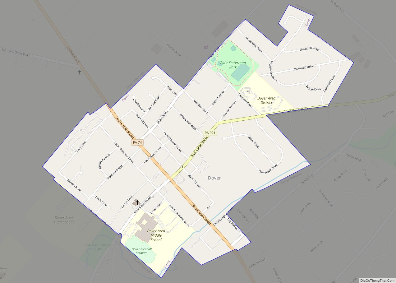
Dover is a borough in York County, Pennsylvania, United States. The population was 1,953 at the 2020 census. Dover borough overview: Name: Dover borough LSAD Code: 21 LSAD Description: borough (suffix) State: Pennsylvania County: York County Incorporated: 1864; 159 years ago (1864) Elevation: 443 ft (135 m) Total Area: 0.54 sq mi (1.41 km²) Land Area: 0.54 sq mi (1.41 km²) Water Area: 0.00 sq mi (0.00 km²) ... Read more
Map of Dover borough, Pennsylvania
Map of Douglassville CDP, Pennsylvania
Douglassville is a census-designated place (CDP) in Amity Township in Berks County, Pennsylvania, United States. Douglassville is situated along U.S. Route 422 and Pennsylvania Route 724. Developments include the Amity Gardens subdivision, the West Ridge subdivision, the Briarwood subdivision, and the High Meadow subdivision. Douglassville also includes Cider Mill and the Woods Edge subdivision along ... Read more
Map of Douglassville CDP, Pennsylvania
Map of Dorneyville CDP
Dorneyville is a census-designated place in Lehigh County, Pennsylvania. As of the 2020 census the population was 4,850. Dorneyville is located just west of Allentown in South Whitehall Township and Salisbury Township. It is located off Interstate 78 and is home to the northern terminus of U.S. Route 222. It is split between the Allentown ... Read more
Map of Dorneyville CDP
Map of Dormont borough
Dormont is a borough in Allegheny County, Pennsylvania, United States and is part of the Pittsburgh Metro Area. The population was 8,244 at the 2020 census. Dormont includes young professionals, working families, and retirees. Dormont is mixed use and urban and features a pedestrian friendly business district, with bars, coffee shops, restaurants, and retail stores. ... Read more
Map of Dormont borough
Map of DuBois city, Pennsylvania
DuBois (/ˈduːbɔɪz/ DOO-boyss) is a city and the most populous community in Clearfield County, Pennsylvania, United States. DuBois is located approximately 100 miles (160 km) northeast of Pittsburgh. The population was 7,510 as of the 2020 census. It is the principal city in the DuBois, PA Micropolitan Statistical Area. DuBois is also one of two principal ... Read more
Map of DuBois city, Pennsylvania
Map of Dublin borough, Pennsylvania
Dublin is a borough in Bucks County, Pennsylvania. The population was 2,158 at the 2010 census. Dublin is part of Pennridge School District. Dublin borough overview: Name: Dublin borough LSAD Code: 21 LSAD Description: borough (suffix) State: Pennsylvania County: Bucks County Elevation: 597 ft (182 m) Total Area: 0.58 sq mi (1.51 km²) Land Area: 0.58 sq mi (1.51 km²) Water Area: 0.00 sq mi ... Read more
Map of Dublin borough, Pennsylvania