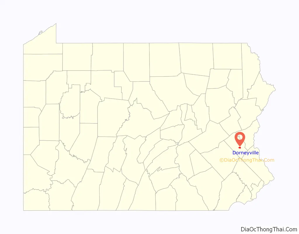
Dorneyville is a census-designated place in Lehigh County, Pennsylvania. As of the 2020 census the population was 4,850. Dorneyville is located just west of Allentown in South Whitehall Township and Salisbury Township.
It is located off Interstate 78 and is home to the northern terminus of U.S. Route 222. It is split between the Allentown ZIP Codes of 18103 and 18104. It is part of the Lehigh Valley metropolitan area, which had a population of 861,899 and was the 68th-most populous metropolitan area in the U.S. as of the 2020 census.
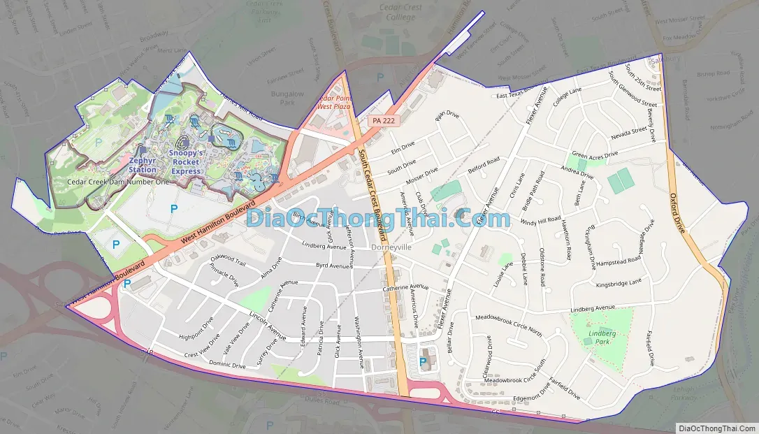
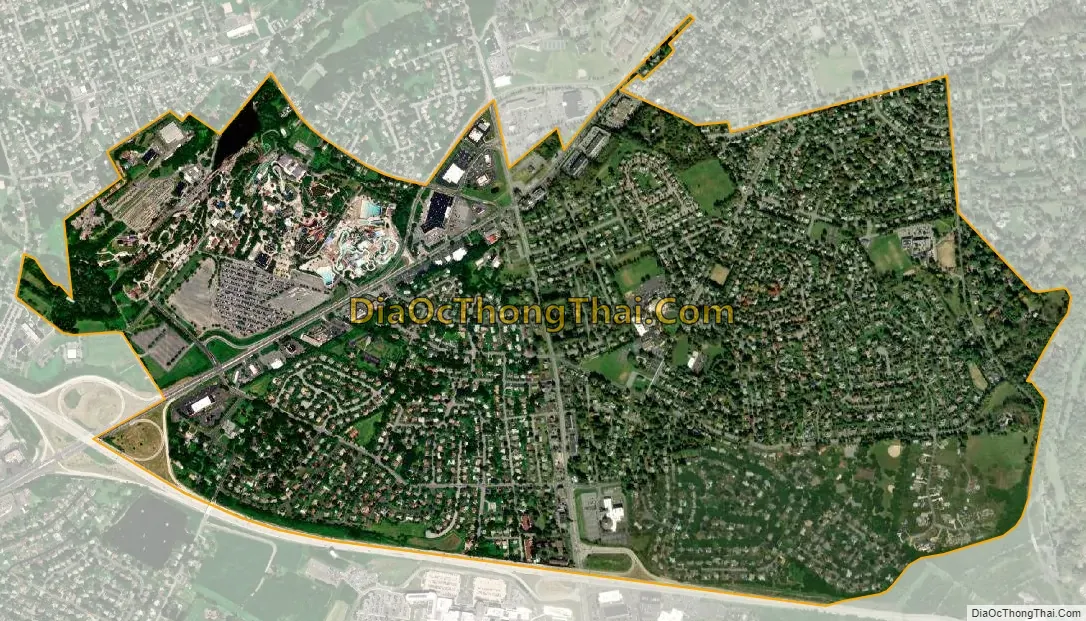
Dorneyville is home to the Dorney Park & Wildwater Kingdom amusement park. The historic King George Inn, founded in 1756, also is located in Dorneyville.
| Name: | Dorneyville CDP |
|---|---|
| LSAD Code: | 57 |
| LSAD Description: | CDP (suffix) |
| State: | Pennsylvania |
| County: | Lehigh County |
| Elevation: | 384 ft (117 m) |
| Land Area: | 2.17 sq mi (5.61 km²) |
| Water Area: | 0.01 sq mi (0.02 km²) |
| Population Density: | 2,238.12/sq mi (864.07/km²) |
| Area code: | 610 and 484 |
| FIPS code: | 4219584 |
| GNISfeature ID: | 1173397 |
Online Interactive Map
Click on ![]() to view map in "full screen" mode.
to view map in "full screen" mode.
Dorneyville location map. Where is Dorneyville CDP?

Dorneyville Road Map
Dorneyville city Satellite Map
Geography
Dorneyville is located in south-central Lehigh County in the southern corner of South Whitehall Township and the west end of Salisbury Township. It is bordered to the northeast and east by the Allentown city limits, and to the northwest by the unincorporated community of Cetronia. Interstate 78 forms the southern boundary of Dorneyville, with access from Exit 54 (US-222/Hamilton Boulevard) and Exit 55 (South Cedar Crest Boulevard). I-78 leads west 80 miles (130 km) to Harrisburg, the state capital, and east 90 miles (140 km) to the Holland Tunnel and Lower Manhattan. US-222 leads southwest 34 miles (55 km) to Reading. South Cedar Crest Boulevard leads south as Pennsylvania Route 29, 3 miles (5 km) to Emmaus.
According to the U.S. Census Bureau, Dorneyville has a total area of 2.0 square miles (5.2 km), of which 0.01 square miles (0.02 km), or 0.46%, are water. Cedar Creek, a northeast-flowing tributary of Little Lehigh Creek, runs through the northwest side of the CDP, where Dorney Park is located. Via the Little Lehigh, Dorneyville is part of the Lehigh River and consequently the Delaware River watersheds.
See also
Map of Pennsylvania State and its subdivision:- Adams
- Allegheny
- Armstrong
- Beaver
- Bedford
- Berks
- Blair
- Bradford
- Bucks
- Butler
- Cambria
- Cameron
- Carbon
- Centre
- Chester
- Clarion
- Clearfield
- Clinton
- Columbia
- Crawford
- Cumberland
- Dauphin
- Delaware
- Elk
- Erie
- Fayette
- Forest
- Franklin
- Fulton
- Greene
- Huntingdon
- Indiana
- Jefferson
- Juniata
- Lackawanna
- Lancaster
- Lawrence
- Lebanon
- Lehigh
- Luzerne
- Lycoming
- Mc Kean
- Mercer
- Mifflin
- Monroe
- Montgomery
- Montour
- Northampton
- Northumberland
- Perry
- Philadelphia
- Pike
- Potter
- Schuylkill
- Snyder
- Somerset
- Sullivan
- Susquehanna
- Tioga
- Union
- Venango
- Warren
- Washington
- Wayne
- Westmoreland
- Wyoming
- York
- Alabama
- Alaska
- Arizona
- Arkansas
- California
- Colorado
- Connecticut
- Delaware
- District of Columbia
- Florida
- Georgia
- Hawaii
- Idaho
- Illinois
- Indiana
- Iowa
- Kansas
- Kentucky
- Louisiana
- Maine
- Maryland
- Massachusetts
- Michigan
- Minnesota
- Mississippi
- Missouri
- Montana
- Nebraska
- Nevada
- New Hampshire
- New Jersey
- New Mexico
- New York
- North Carolina
- North Dakota
- Ohio
- Oklahoma
- Oregon
- Pennsylvania
- Rhode Island
- South Carolina
- South Dakota
- Tennessee
- Texas
- Utah
- Vermont
- Virginia
- Washington
- West Virginia
- Wisconsin
- Wyoming