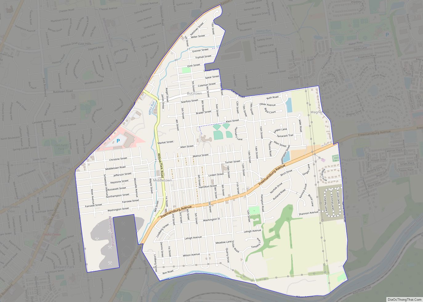
Map of Middleburg borough, Pennsylvania
Middleburg is a borough in Snyder County, Pennsylvania, United States. Located in Central Pennsylvania’s Susquehanna River Valley, the borough’s population was 1,325 at the 2020 census. It is the county seat of Snyder County. Middleburg is part of the Selinsgrove, PA Micropolitan Statistical Area, and is also part of the larger Bloomsburg-Berwick-Sunbury, PA Combined Statistical ... Read more
Map of Middleburg borough, Pennsylvania
Map of Meyersdale borough
Meyersdale is a borough in Somerset County, Pennsylvania, United States, situated on the Casselman River, 73 miles (117 km) southeast of Pittsburgh. It is part of the Johnstown, Pennsylvania, Metropolitan Statistical Area. In the past, Meyersdale’s chief industry was the mining of coal. Meyersdale is located along the Great Allegheny Passage, a multi-use recreational rail trail. ... Read more
Map of Meyersdale borough
Map of Mexico CDP, Pennsylvania
Mexico is an unincorporated community and census-designated place (CDP) in Walker Township, Juniata County, Pennsylvania, United States. The population was 472 at the time of the 2010 census. Mexico CDP overview: Name: Mexico CDP LSAD Code: 57 LSAD Description: CDP (suffix) State: Pennsylvania County: Juniata County Elevation: 443 ft (135 m) Total Area: 1.08 sq mi (2.81 km²) Land Area: ... Read more
Map of Mexico CDP, Pennsylvania
Map of Messiah College CDP
Messiah University is a private interdenominational evangelical Christian university in Mechanicsburg, Pennsylvania. Messiah College CDP overview: Name: Messiah College CDP LSAD Code: 57 LSAD Description: CDP (suffix) State: Pennsylvania County: Cumberland County FIPS code: 4248868 Website: www.messiah.edu Online Interactive Map Messiah College online map. Source: Basemap layers from Google Map, Open Street Map (OSM), Arcgisonline, ... Read more
Map of Messiah College CDP
Map of Meshoppen borough
Meshoppen is a borough that is located in Wyoming County, Pennsylvania, United States. The population was 326 at the time of the 2020 census. Meshoppen borough overview: Name: Meshoppen borough LSAD Code: 21 LSAD Description: borough (suffix) State: Pennsylvania County: Wyoming County Elevation: 623 ft (190 m) Total Area: 0.77 sq mi (2.00 km²) Land Area: 0.69 sq mi (1.79 km²) Water Area: ... Read more
Map of Meshoppen borough
Map of Mertztown CDP
Mertztown is a census-designated place in Longswamp Township, Berks County, Pennsylvania, United States. It is located near the borough of Topton. As of the 2010 census, the population was 664 residents. Mertztown is located in Berks County at latitude 40.506 and longitude -75.665 (Mertztown Panoramio Photos.) and its elevation is 466 feet. It appears on ... Read more
Map of Mertztown CDP
Map of Milford Square CDP
Milford Square is a census-designated place in Milford Township, Bucks County, Pennsylvania, United States. It is located along PA Route 663 near the borough of Trumbauersville. As of the 2010 census, the population was 897 residents. While the village has a PO Box post office, with the ZIP code of 18935, the surrounding area uses ... Read more
Map of Milford Square CDP
Map of Milesburg borough
Milesburg is a borough in Centre County, Pennsylvania. It is part of the State College, Pennsylvania metropolitan statistical area. The population was 1,093 at the 2020 census. Milesburg borough overview: Name: Milesburg borough LSAD Code: 21 LSAD Description: borough (suffix) State: Pennsylvania County: Centre County Elevation: 692 ft (211 m) Total Area: 0.44 sq mi (1.13 km²) Land Area: 0.44 sq mi ... Read more
Map of Milesburg borough
Map of Mifflinville CDP
Mifflinville is an unincorporated community and census-designated place (CDP) in Columbia County, Pennsylvania, United States. It is part of Northeastern Pennsylvania. The population was 1,253 at the 2010 census. It is part of the Bloomsburg-Berwick micropolitan area. Mifflinville CDP overview: Name: Mifflinville CDP LSAD Code: 57 LSAD Description: CDP (suffix) State: Pennsylvania County: Columbia County ... Read more
Map of Mifflinville CDP
Map of Mifflintown borough
Mifflintown is a borough in and the county seat of Juniata County, Pennsylvania, United States. The population was 842 at the 2020 census. Mifflintown borough overview: Name: Mifflintown borough LSAD Code: 21 LSAD Description: borough (suffix) State: Pennsylvania County: Juniata County Incorporated: 1833 Total Area: 0.14 sq mi (0.36 km²) Land Area: 0.14 sq mi (0.36 km²) Water Area: 0.00 sq mi (0.00 km²) ... Read more
Map of Mifflintown borough
Map of Mifflinburg borough
Mifflinburg is a borough in Union County, located in the Susquehanna River Valley of central Pennsylvania, United States. Mifflinburg was first settled in 1792 by Elias and Catharina Jungman (later Youngman) and their two children. They divided the land into 60′ by 120′ plots that were sold to other settlers, many of them German, and ... Read more
Map of Mifflinburg borough
Map of Mifflin borough, Pennsylvania
Mifflin is a borough in Juniata County, Pennsylvania, United States. The population was 534 at the 2020 census. Mifflin borough overview: Name: Mifflin borough LSAD Code: 21 LSAD Description: borough (suffix) State: Pennsylvania County: Juniata County Incorporated: 1853 Total Area: 0.17 sq mi (0.45 km²) Land Area: 0.17 sq mi (0.45 km²) Water Area: 0.00 sq mi (0.00 km²) Total Population: 530 Population Density: ... Read more
Map of Mifflin borough, Pennsylvania