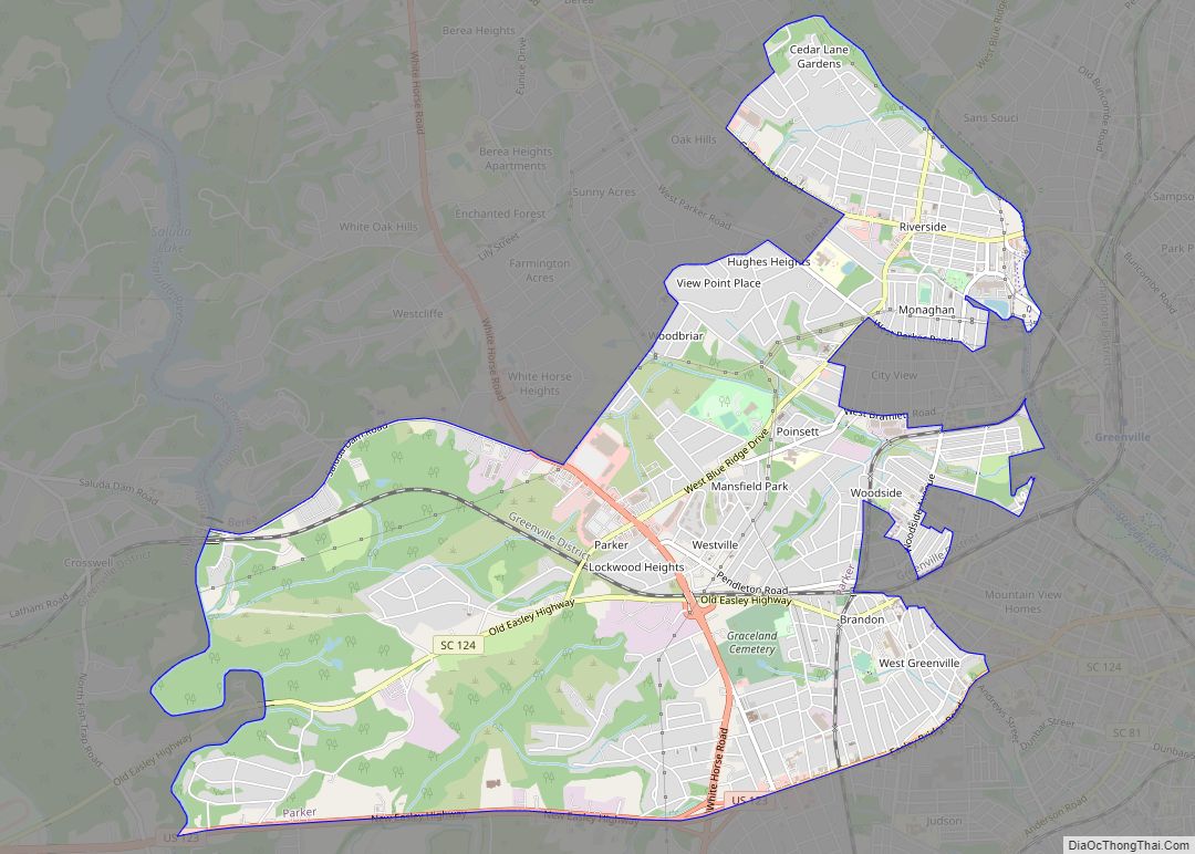
Map of Parksville town

Map of Parksville town

Parksville is a town in McCormick County, South Carolina, United States. The population was 117 at the 2010 census. Parksville town overview: Name: Parksville town LSAD Code: 43 LSAD Description: town (suffix) State: South Carolina County: McCormick County Elevation: 348 ft (106 m) Total Area: 0.73 sq mi (1.89 km²) Land Area: 0.73 sq mi (1.89 km²) Water Area: 0.00 sq mi (0.00 km²) Total Population: … Read more

Map of Plum Branch town

Map of Plum Branch town

Plum Branch is a town in McCormick County, South Carolina, United States. The population was 82 at the 2010 census. Plum Branch town overview: Name: Plum Branch town LSAD Code: 43 LSAD Description: town (suffix) State: South Carolina County: McCormick County Elevation: 459 ft (140 m) Total Area: 0.36 sq mi (0.94 km²) Land Area: 0.36 sq mi (0.94 km²) Water Area: 0.00 sq mi … Read more

Map of Pinopolis CDP

Map of Pinopolis CDP

Pinopolis is an unincorporated community and census-designated place in Berkeley County, South Carolina, United States. As of the 2010 census it had a population of 948. Pinopolis CDP overview: Name: Pinopolis CDP LSAD Code: 57 LSAD Description: CDP (suffix) State: South Carolina County: Berkeley County Elevation: 91 ft (28 m) Total Area: 1.43 sq mi (3.71 km²) Land Area: 1.43 sq mi … Read more

Map of Pinewood town, South Carolina

Map of Pinewood town, South Carolina

Pinewood is a town located on South Carolina Highway 261 at the southern entrance to the High Hills of Santee in Sumter County, South Carolina, United States. The population was 538 at the 2010 census. It is included in the Sumter, South Carolina Metropolitan Statistical Area. Pinewood town overview: Name: Pinewood town LSAD Code: 43 … Read more

Map of Pine Ridge town, South Carolina

Map of Pine Ridge town, South Carolina

Pine Ridge is a town in Lexington County, South Carolina, United States. The population was 2,064 at the 2010 census. It is part of the Columbia, South Carolina Metropolitan Statistical Area. Pine Ridge town overview: Name: Pine Ridge town LSAD Code: 43 LSAD Description: town (suffix) State: South Carolina County: Lexington County Elevation: 256 ft (78 m) … Read more

Map of Piedmont CDP, South Carolina

Map of Piedmont CDP, South Carolina

Piedmont is a census-designated place (CDP) along the Saluda River in Anderson and Greenville counties in the U.S. state of South Carolina. The population was 5,411 at the 2020 census. Piedmont is a part of the Greenville-Anderson metropolitan area. Piedmont CDP overview: Name: Piedmont CDP LSAD Code: 57 LSAD Description: CDP (suffix) State: South Carolina … Read more

Map of Pickens city, South Carolina

Map of Pickens city, South Carolina

Pickens, formerly called Pickens Courthouse, is a city in Pickens County, South Carolina, United States. The population was 3,126 at the 2010 census. Pickens changed its classification from a town to a city in 1998, but it was not reported to the Census Bureau until 2001. It is the county seat of Pickens County. It … Read more

Map of Perry town, South Carolina

Map of Perry town, South Carolina

Perry is a town in Aiken County, South Carolina, United States. The population was 233 at the 2010 census. It is part of the Augusta, Georgia metropolitan area. Perry town overview: Name: Perry town LSAD Code: 43 LSAD Description: town (suffix) State: South Carolina County: Aiken County Elevation: 440 ft (134 m) Total Area: 0.96 sq mi (2.48 km²) Land … Read more

Map of Pendleton town, South Carolina

Map of Pendleton town, South Carolina

Pendleton is a town in Anderson County, South Carolina, United States. The population was 3,489 at the 2020 census. It is a sister city of Stornoway in the Outer Hebrides of Scotland. The Pendleton Historic District, consisting of the town and its immediate surroundings, was added to the National Register of Historic Places in 1970. … Read more

Map of Pelzer town

Map of Pelzer town

Pelzer is a town in Anderson County in South Carolina, United States, along the Saluda River. The population was 89 at the 2010 census, and grew to 1,344 at the 2020 census. Pelzer town overview: Name: Pelzer town LSAD Code: 43 LSAD Description: town (suffix) State: South Carolina County: Anderson County Elevation: 742 ft (229 m) Total … Read more

Map of Pelion town

Map of Pelion town

Pelion is a town in Lexington County, South Carolina, United States. The population was 674 at the 2010 census. It is part of the Columbia, South Carolina Metropolitan Statistical Area. Pelion town overview: Name: Pelion town LSAD Code: 43 LSAD Description: town (suffix) State: South Carolina County: Lexington County Incorporated: 1912 Elevation: 387 ft (118 m) Total … Read more

Map of Pomaria town

Map of Pomaria town

Pomaria is a town in Newberry County, South Carolina, United States. The population was 179 at the 2010 census. Pomaria town overview: Name: Pomaria town LSAD Code: 43 LSAD Description: town (suffix) State: South Carolina County: Newberry County Elevation: 404 ft (123 m) Total Area: 1.05 sq mi (2.73 km²) Land Area: 1.05 sq mi (2.71 km²) Water Area: 0.01 sq mi (0.02 km²) Total Population: … Read more