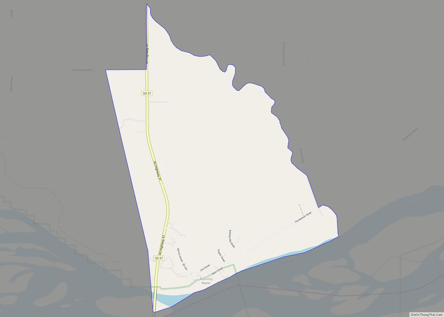
Map of Sherman town, South Dakota

Map of Sherman town, South Dakota

Sherman is a town in Minnehaha County, South Dakota, United States. The population was 81 at the 2020 census. The town has the name of E. A . Sherman, a Dakota Territory banker. Sherman town overview: Name: Sherman town LSAD Code: 43 LSAD Description: town (suffix) State: South Dakota County: Minnehaha County Incorporated: 1888 Elevation: … Read more

Map of Seneca town, South Dakota

Map of Seneca town, South Dakota

Seneca is a town in Faulk County, South Dakota, United States. The population was 22 at the 2020 census. Seneca town overview: Name: Seneca town LSAD Code: 43 LSAD Description: town (suffix) State: South Dakota County: Faulk County Elevation: 1,906 ft (581 m) Total Area: 0.42 sq mi (1.08 km²) Land Area: 0.42 sq mi (1.08 km²) Water Area: 0.00 sq mi (0.00 km²) Total Population: … Read more

Map of Selby city

Map of Selby city

Selby is a city in Walworth County, South Dakota, United States. The population was 610 at the 2020 census. It is the county seat of Walworth County. Selby city overview: Name: Selby city LSAD Code: 25 LSAD Description: city (suffix) State: South Dakota County: Walworth County Incorporated: 1909 Elevation: 1,903 ft (580 m) Total Area: 0.71 sq mi (1.84 km²) … Read more

Map of St. Lawrence town, South Dakota

Map of St. Lawrence town, South Dakota

St. Lawrence is a town in central Hand County, South Dakota, United States. The population was 164 at the 2020 census. St. Lawrence town overview: Name: St. Lawrence town LSAD Code: 43 LSAD Description: town (suffix) State: South Dakota County: Hand County Elevation: 1,568 ft (478 m) Total Area: 0.34 sq mi (0.89 km²) Land Area: 0.34 sq mi (0.89 km²) Water Area: … Read more

Map of St. Francis town, South Dakota

Map of St. Francis town, South Dakota

St. Francis also Sápauŋ thí (Lakota: Sápauŋ thí; “Catholic House”) is a town on the Rosebud Indian Reservation in Todd County, South Dakota, United States. The population was 469 at the 2020 census. St. Francis took its name from the St. Francis Indian School, which had the name of Francis of Assisi and was operated … Read more

Map of St. Charles CDP, South Dakota

Map of St. Charles CDP, South Dakota

St. Charles is a census-designated place (CDP) in Gregory County, South Dakota, United States. The population was 15 at the 2020 census. St. Charles was laid out in 1906, and most likely was named in honor of Charlie Johnson, a first settler. St. Charles CDP overview: Name: St. Charles CDP LSAD Code: 57 LSAD Description: … Read more

Map of Springfield city, South Dakota

Map of Springfield city, South Dakota

Springfield is a city in Bon Homme County, South Dakota, United States. The population was 1,914 at the 2020 census. As of 2012, about 1,200 of the residents were inmates at Mike Durfee State Prison. Springfield was named on account of there being numerous natural springs in the area. Springfield city overview: Name: Springfield city … Read more

Map of Spring Creek CDP, South Dakota

Map of Spring Creek CDP, South Dakota

Spring Creek is a census-designated place (CDP) in Todd County, South Dakota, United States. The population was 236 at the 2020 census. Spring Creek CDP overview: Name: Spring Creek CDP LSAD Code: 57 LSAD Description: CDP (suffix) State: South Dakota County: Todd County Total Area: 9.3 sq mi (24.1 km²) Land Area: 9.3 sq mi (24.1 km²) Water Area: 0 sq mi (0 km²) … Read more

Map of Spencer city, South Dakota

Map of Spencer city, South Dakota

Spencer is a city in McCook County, South Dakota, United States. The population was 136 at the 2020 census. The city was almost destroyed by a violent F4 tornado on May 30, 1998 which killed six people. Spencer city overview: Name: Spencer city LSAD Code: 25 LSAD Description: city (suffix) State: South Dakota County: McCook … Read more

Map of Spearfish city

Map of Spearfish city

Spearfish (Lakota: Hočhápȟe) is a city in Lawrence County, South Dakota. The population was 12,193 at the time of the 2020 census. Spearfish city overview: Name: Spearfish city LSAD Code: 25 LSAD Description: city (suffix) State: South Dakota County: Lawrence County Founded: 1876 Incorporated: 1888 Elevation: 3,648 ft (1,112 m) Land Area: 17.24 sq mi (44.64 km²) Water Area: 0.01 sq mi … Read more

Map of South Shore town, South Dakota

Map of South Shore town, South Dakota

South Shore is a town in Codington County, South Dakota, United States. The population was 189 at the 2020 census. It is part of the Watertown, South Dakota Micropolitan Statistical Area. South Shore town overview: Name: South Shore town LSAD Code: 43 LSAD Description: town (suffix) State: South Dakota County: Codington County Incorporated: March 6, … Read more

Map of Soldier Creek CDP

Map of Soldier Creek CDP

Soldier Creek is an unincorporated community and census-designated place in Todd County, South Dakota, United States. Its population was 205 as of the 2020 census. U.S. Route 18 passes through the community. Soldier Creek CDP overview: Name: Soldier Creek CDP LSAD Code: 57 LSAD Description: CDP (suffix) State: South Dakota County: Todd County Elevation: 2,342 ft … Read more