Map of Hillsboro CDP, Tennessee

Map of Hillsboro CDP, Tennessee

Hillsboro is an unincorporated community in Coffee County, Tennessee, United States, that was treated as a census-designated place for the 2010 U.S. Census. The population was 450 as of the 2010 census. The community is concentrated around the intersection of U.S. Route 41 and Tennessee State Route 127, between Manchester to the northwest and Monteagle … Read more

Map of Hickory Valley town

Map of Hickory Valley town

Hickory Valley is a town in Hardeman County, Tennessee, United States. The population was 99 at the 2010 census. Hickory Valley’s origin dates back to the blending of three independent pioneer settlements in the area that were founded by three men: William Shinault in 1820, Drury Wood in 1826 and William Barnett in 1827. Hickory … Read more

Map of Henry town, Tennessee

Map of Henry town, Tennessee

Henry is a town in Henry County, Tennessee. The population was 520 at the 2000 census and 464 at the 2010 census, showing decline of 56. Gospel singer Bobby Jones was born here. Henry town overview: Name: Henry town LSAD Code: 43 LSAD Description: town (suffix) State: Tennessee County: Henry County Elevation: 548 ft (167 m) Total … Read more

Map of Henning town, Tennessee

Map of Henning town, Tennessee

Henning is a town in Lauderdale County, Tennessee, United States. The population was 945 at the 2010 census. Henning town overview: Name: Henning town LSAD Code: 43 LSAD Description: town (suffix) State: Tennessee County: Lauderdale County Elevation: 292 ft (89 m) Total Area: 2.47 sq mi (6.40 km²) Land Area: 2.47 sq mi (6.39 km²) Water Area: 0.00 sq mi (0.01 km²) Total Population: 871 Population … Read more

Map of Hendersonville city, Tennessee

Map of Hendersonville city, Tennessee

Hendersonville is the largest city in Sumner County, Tennessee, on Old Hickory Lake. The population was 61,753 at the 2020 census. Hendersonville is the fourth-largest city in the Nashville metropolitan area after Nashville, Murfreesboro, and Franklin and the 10th largest in Tennessee. Hendersonville is located 18 miles northeast of downtown Nashville. The city was settled … Read more

Map of Henderson city, Tennessee

Map of Henderson city, Tennessee

Henderson is a city in and the county seat of Chester County, Tennessee, United States. The population was 6,309 at the 2010 census, up from 5,670 at the 2000 census. Henderson city overview: Name: Henderson city LSAD Code: 25 LSAD Description: city (suffix) State: Tennessee County: Chester County Elevation: 446 ft (136 m) Total Area: 7.83 sq mi (20.29 km²) … Read more

Map of Helenwood CDP

Map of Helenwood CDP

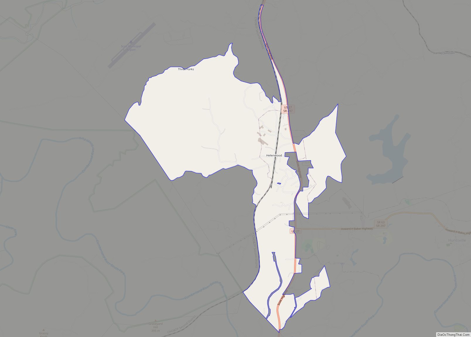
Helenwood is an unincorporated community in Scott County, Tennessee, United States. The population was 846 at the 2000 census, when Helenwood was treated as an incorporated municipality. For the 2010 census, it was a census-designated place (CDP) with a population of 865. Helenwood CDP overview: Name: Helenwood CDP LSAD Code: 57 LSAD Description: CDP (suffix) … Read more

Map of Hornsby town

Map of Hornsby town

Hornsby is a town in Hardeman County, Tennessee. The population was 303 at the 2010 census. The town is just east of Bolivar along U.S. Highway 64. Hornsby town overview: Name: Hornsby town LSAD Code: 43 LSAD Description: town (suffix) State: Tennessee County: Hardeman County Elevation: 381 ft (116 m) Total Area: 1.05 sq mi (2.72 km²) Land Area: 1.05 sq mi … Read more

Map of Hornbeak town

Map of Hornbeak town

Hornbeak is a town in Obion County, Tennessee, United States. The population was 424 as of the 2010 census. It is part of the Union City, TN–KY Micropolitan Statistical Area. Hornbeak was originally known as Wilsonville, not to be confused with the settlement of the same name in Cocke County. It was renamed Hornbeak after … Read more

Map of Jackson city, Tennessee

Map of Jackson city, Tennessee

Jackson is a city in and the county seat of Madison County, Tennessee, United States. Located 70 miles (110 km) east of Memphis, it is a regional center of trade for West Tennessee. Its total population was 68,205 as of the 2020 United States census. Jackson is the primary city of the Jackson, Tennessee metropolitan area, … Read more

Map of Jacksboro town

Map of Jacksboro town, Tennessee

Jacksboro is a town in Campbell County, Tennessee, United States. The population was 2,020 at the 2010 census, and 2,306 at the 2020 census. It is the county seat of Campbell County. Jacksboro town overview: Name: Jacksboro town LSAD Code: 43 LSAD Description: town (suffix) State: Tennessee County: Campbell County Founded: 1806 Incorporated: 1967 Elevation: … Read more

Map of Iron City CDP, Tennessee

Map of Iron City CDP, Tennessee

Iron City CDP overview: Name: Iron City CDP LSAD Code: 57 LSAD Description: CDP (suffix) State: Tennessee County: Lawrence County, Wayne County FIPS code: 4737360 Online Interactive Map Iron City online map. Source: Basemap layers from Google Map, Open Street Map (OSM), Arcgisonline, Wmflabs. Boundary Data from Database of Global Administrative Areas. Iron City location … Read more