Map of Mosheim town
Mosheim (pronounced Moss-hime) is a town in Greene County, Tennessee, United States. The population was 2,479 at the 2020 census. Mosheim town overview: Name: Mosheim town LSAD Code: 43 LSAD Description: town (suffix) State: Tennessee County: Greene County Incorporated: 1974 Elevation: 1,289 ft (393 m) Total Area: 6.27 sq mi (16.24 km²) Land Area: 6.27 sq mi (16.24 km²) Water Area: 0.00 sq mi (0.00 km²) ... Read more
Map of Mosheim town
Map of Moscow city, Tennessee
Moscow (/ˈmɒskoʊ/ MOS-koh) is a city in Fayette County, Tennessee, United States. The population was 568 at the 2020 census, 556 at the 2010 census, and 422 at the 2000 census. The town was named after a Cherokee Chief [Mosgo], meaning “Town between 2 rivers.” North Fork and Wolf Rivers. The Army Corps of Engineers ... Read more
Map of Moscow city, Tennessee
Map of Morristown city, Tennessee
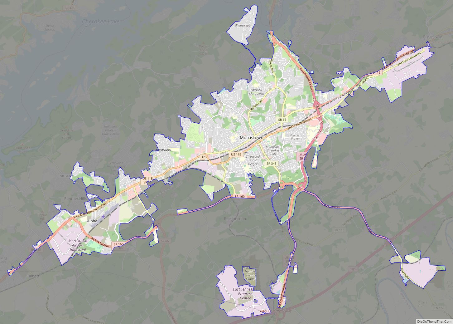
Morristown is a city in and the county seat of Hamblen County, Tennessee, United States. Morristown also extends into Jefferson County on the western and southern ends. The city’s population was recorded to be 30,431 at the 2020 United States census. It is the principal city of the Morristown Metropolitan Statistical Area, which encompasses all ... Read more
Map of Morristown city, Tennessee
Map of New Tazewell town
New Tazewell is a city in Claiborne County, Tennessee, United States. The population was 3,037 at the 2010 census.The population was 2,769 at the 2020 census. New Tazewell town overview: Name: New Tazewell town LSAD Code: 43 LSAD Description: town (suffix) State: Tennessee County: Claiborne County Incorporated: 1954 Elevation: 1,467 ft (447 m) Total Area: 5.07 sq mi (13.12 km²) ... Read more
Map of New Tazewell town
Map of New Market town, Tennessee
New Market is a town in Jefferson County, Tennessee, United States. It is part of the Morristown metropolitan area. The population was 1,334 at the 2010 census and 1,349 at the 2020 census. New Market town overview: Name: New Market town LSAD Code: 43 LSAD Description: town (suffix) State: Tennessee County: Jefferson County Incorporated: 1911 ... Read more
Map of New Market town, Tennessee
Map of New Johnsonville city
New Johnsonville is a city in Humphreys County, Tennessee, United States. The population was 1,951 at the 2010 census. New Johnsonville city overview: Name: New Johnsonville city LSAD Code: 25 LSAD Description: city (suffix) State: Tennessee County: Humphreys County Incorporated: 1949 Elevation: 436 ft (133 m) Total Area: 6.88 sq mi (17.83 km²) Land Area: 5.14 sq mi (13.33 km²) Water Area: 1.74 sq mi ... Read more
Map of New Johnsonville city
Map of New Hope city, Tennessee
New Hope is a town in Marion County, Tennessee, United States. The population is 987. It is part of the Chattanooga, TN–GA Metropolitan Statistical Area. New Hope city overview: Name: New Hope city LSAD Code: 25 LSAD Description: city (suffix) State: Tennessee County: Marion County Elevation: 715 ft (218 m) Total Area: 10.4 sq mi (26.9 km²) Land Area: 10.3 sq mi ... Read more
Map of New Hope city, Tennessee
Map of New Deal CDP, Tennessee
New Deal is a census-designated place and unincorporated community in Sumner County, Tennessee, United States. Its population was 368 as of the 2010 census. New Deal CDP overview: Name: New Deal CDP LSAD Code: 57 LSAD Description: CDP (suffix) State: Tennessee County: Sumner County Elevation: 919 ft (280 m) Total Area: 1.89 sq mi (4.91 km²) Land Area: 1.89 sq mi (4.91 km²) ... Read more
Map of New Deal CDP, Tennessee
Map of Munford city, Tennessee
Munford is a city in Tipton County, Tennessee. The population was 5,927 at the 2010 census, when it was listed as a town. Munford city overview: Name: Munford city LSAD Code: 25 LSAD Description: city (suffix) State: Tennessee County: Tipton County Elevation: 446 ft (136 m) Total Area: 9.49 sq mi (24.58 km²) Land Area: 9.48 sq mi (24.55 km²) Water Area: 0.01 sq mi ... Read more
Map of Munford city, Tennessee
Map of Mowbray Mountain CDP
Mowbray Mountain is a census-designated place in Hamilton County, Tennessee, United States. Its population was 1,705 as of the 2020 census, up from 1,615 as of the 2010 census. Mowbray Mountain CDP overview: Name: Mowbray Mountain CDP LSAD Code: 57 LSAD Description: CDP (suffix) State: Tennessee County: Hamilton County Elevation: 1,660 ft (510 m) Total Area: 20.22 sq mi ... Read more
Map of Mowbray Mountain CDP
Map of Mountain City town, Tennessee
Mountain City is a town in and the county seat of Johnson County, Tennessee, United States. The population was 2,383 at the 2000 census and 2,531 at the 2010 census. It is the northeasternmost county seat in Tennessee. In addition, at an elevation of 2,418 feet (737 m), it has the distinction of being the highest ... Read more
Map of Mountain City town, Tennessee
Map of Mount Pleasant city, Tennessee
Mount Pleasant is a city in Maury County, Tennessee, United States. Mount Pleasant was the birthplace of 19th-century writer and humorist Samuel R. Watkins and formerly titled “The Phosphate Capital of the World.” The population was 4,561 at the 2010 census, and 4,784 in 2020. Mount Pleasant city overview: Name: Mount Pleasant city LSAD Code: ... Read more
Map of Mount Pleasant city, Tennessee