Map of Pelham CDP, Tennessee
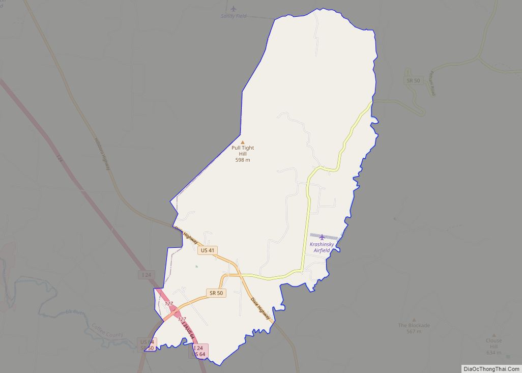
Pelham is an unincorporated community and census-designated place (CDP) in Grundy County, Tennessee, United States. As of the 2010 census, its population was 403. Pelham is located at the junction of U.S. Route 41, State Route 2, and State Route 50 near the base of the Cumberland Plateau, 5.35 miles (8.61 km) north-northwest of Monteagle. Pelham ... Read more
Map of Pelham CDP, Tennessee
Map of Pegram town
Pegram is a town completely in Cheatham County, Tennessee, United States. The population was 2,093 at the 2010 census and 2,072 people at the 2020 census. Pegram town overview: Name: Pegram town LSAD Code: 43 LSAD Description: town (suffix) State: Tennessee County: Cheatham County Elevation: 551 ft (168 m) Total Area: 7.25 sq mi (18.77 km²) Land Area: 7.25 sq mi (18.77 km²) ... Read more
Map of Pegram town
Map of Parsons city, Tennessee
Parsons is a city in Decatur County, Tennessee, United States. The population was 2,373 at the 2010 census. Parsons is the largest city by population in Decatur County. Parsons city overview: Name: Parsons city LSAD Code: 25 LSAD Description: city (suffix) State: Tennessee County: Decatur County Elevation: 495 ft (151 m) Total Area: 4.05 sq mi (10.48 km²) Land Area: ... Read more
Map of Parsons city, Tennessee
Map of Parrottsville town
Parrottsville is a town in Cocke County, Tennessee, United States. The population was 263 at the 2010 census. Parrottsville town overview: Name: Parrottsville town LSAD Code: 43 LSAD Description: town (suffix) State: Tennessee County: Cocke County Incorporated: 1923 Elevation: 1,188 ft (362 m) Total Area: 0.74 sq mi (1.92 km²) Land Area: 0.74 sq mi (1.92 km²) Water Area: 0.00 sq mi (0.00 km²) Total Population: ... Read more
Map of Parrottsville town
Map of Parker’s Crossroads city
Parkers Crossroads is a city in Henderson County, Tennessee, United States. The population was 330 as of the 2010 census, up from 241 at the 2000 census. Parker’s Crossroads city overview: Name: Parker’s Crossroads city LSAD Code: 25 LSAD Description: city (suffix) State: Tennessee County: Henderson County Incorporated: June 2, 1981 Elevation: 522 ft (159 m) Total ... Read more
Map of Parker’s Crossroads city
Map of Park City CDP, Tennessee
Park City is a census-designated place (CDP) in Lincoln County, Tennessee, United States. As of the 2010 census, its population was 2,442. Park City is the location of the Fayetteville Municipal Airport. Park City CDP overview: Name: Park City CDP LSAD Code: 57 LSAD Description: CDP (suffix) State: Tennessee County: Lincoln County Elevation: 1,001 ft (305 m) ... Read more
Map of Park City CDP, Tennessee
Map of Paris city, Tennessee
Paris is a city in and the county seat of Henry County, Tennessee, United States. As of the 2020 census, the city had a population of 10,316. A 70-foot (21 m) replica of the Eiffel Tower stands in the southern part of Paris. Paris city overview: Name: Paris city LSAD Code: 25 LSAD Description: city (suffix) ... Read more
Map of Paris city, Tennessee
Map of Pittman Center town
Pittman Center is a town in Sevier County, Tennessee, United States. The population was 454 at the 2020 census and 502 at the 2010 census. The town borders Gatlinburg and the Great Smoky Mountains National Park. U.S. 321 passes through the town. Emert’s Cove is situated in Pittman Center, a broad valley along the Middle ... Read more
Map of Pittman Center town
Map of Piperton city
Piperton is a city in Fayette County, Tennessee, United States. The population was 2,263 at the 2020 census. In 2007 USA Today cited the National Motorist Association when it listed Piperton as one of the worst cities for speeding tickets across the USA. Piperton city overview: Name: Piperton city LSAD Code: 25 LSAD Description: city ... Read more
Map of Piperton city
Map of Pine Crest CDP
Pine Crest is a census-designated place (CDP) in Carter County, Tennessee, United States. The population was 2,388 at the 2010 census. It is part of the Johnson City Metropolitan Statistical Area, which is a component of the Johnson City–Kingsport–Bristol, TN-VA Combined Statistical Area – commonly known as the “Tri-Cities” region. Pine Crest CDP overview: Name: ... Read more
Map of Pine Crest CDP
Map of Pikeville city, Tennessee
Pikeville is a city in Bledsoe County, Tennessee, United States. The population was 2,251 at the 2010 census. It is also the county seat of Bledsoe County. Pikeville city overview: Name: Pikeville city LSAD Code: 25 LSAD Description: city (suffix) State: Tennessee County: Bledsoe County Founded: 1816 Incorporated: 1830 Elevation: 860 ft (260 m) Total Area: 2.44 sq mi ... Read more
Map of Pikeville city, Tennessee
Map of Pigeon Forge city
Pigeon Forge is a mountain resort city in Sevier County, Tennessee, in the southeastern United States. As of the 2020 census, the city had a total population of 6,343. Situated just 5 miles (8 km) north of Great Smoky Mountains National Park, Pigeon Forge is a tourist destination that caters primarily to Southern culture and country ... Read more
Map of Pigeon Forge city