Map of Smithville city, Tennessee

Map of Smithville city, Tennessee

Smithville is a city in DeKalb County, Tennessee, United States. The population was 5,004 at the 2020 census, up from 3,994 at the 2010 census. It is the county seat of DeKalb County. Smithville is home to the Smithville Fiddler’s Jamboree, which it has hosted annually since 1972. Smithville city overview: Name: Smithville city LSAD … Read more

Map of Slayden town

Map of Slayden town

Slayden is a town in Dickson County, Tennessee, United States. The population was 178 at the 2010 census. Slayden town overview: Name: Slayden town LSAD Code: 43 LSAD Description: town (suffix) State: Tennessee County: Dickson County Elevation: 735 ft (224 m) Total Area: 1.53 sq mi (3.97 km²) Land Area: 1.53 sq mi (3.97 km²) Water Area: 0.00 sq mi (0.00 km²) Total Population: 170 Population … Read more

Map of Silerton town

Map of Silerton town

Silerton is a town in Hardeman and Chester counties in the western part of Tennessee. The population was 111 at the 2010 census. Silerton town overview: Name: Silerton town LSAD Code: 43 LSAD Description: town (suffix) State: Tennessee County: Chester County, Hardeman County Elevation: 427 ft (137 m) Total Area: 0.67 sq mi (1.73 km²) Land Area: 0.67 sq mi (1.73 km²) Water … Read more

Map of Signal Mountain town

Map of Signal Mountain town

Signal Mountain is a town in Hamilton County, Tennessee, United States. The town is a suburb of Chattanooga and is located on Walden Ridge. “Signal Mountain” is used as a colloquial name for the part of Walden Ridge close to the town. The town population was 8,852 as of the 2020 census and estimated to … Read more

Map of Shelbyville city, Tennessee

Map of Shelbyville city, Tennessee

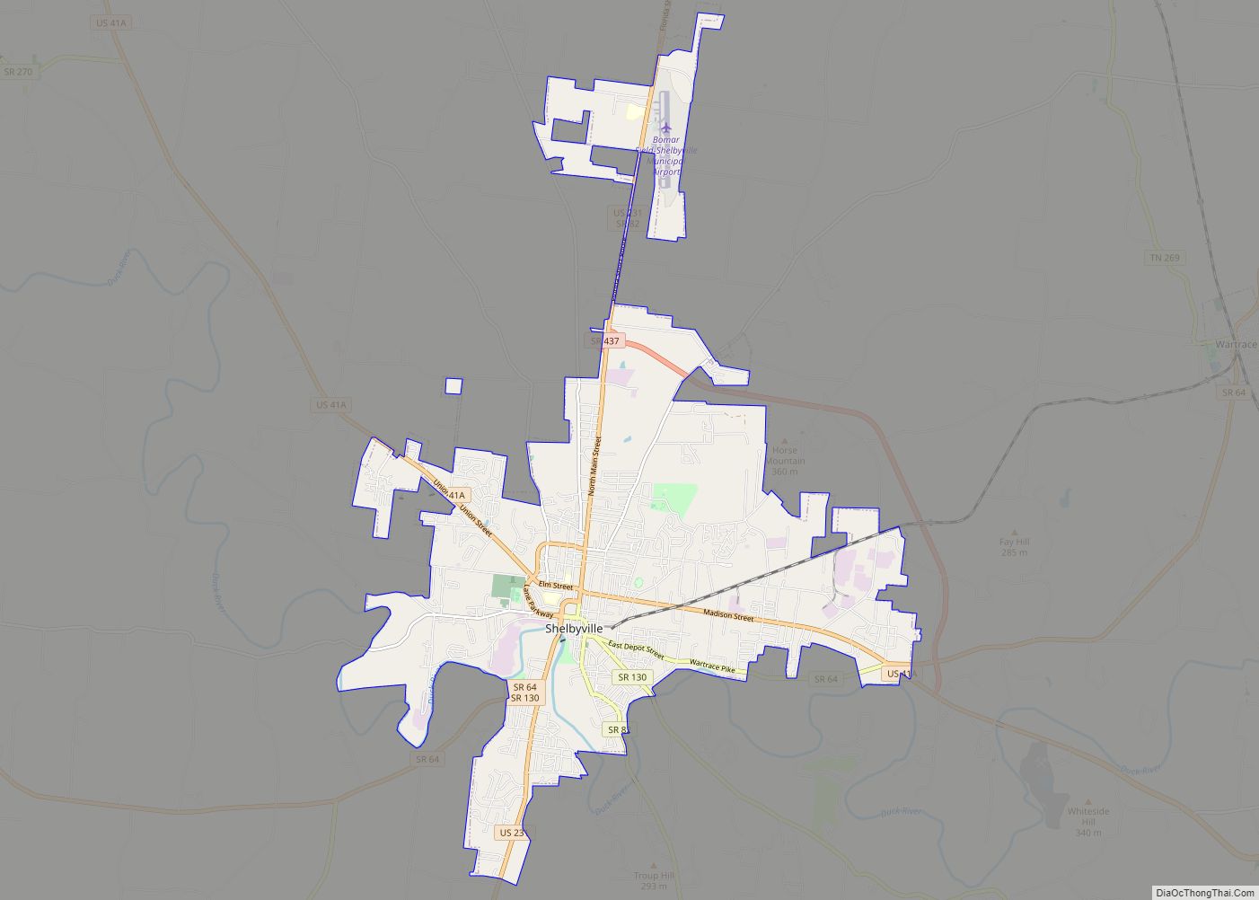
Shelbyville is a city in and the county seat of Bedford County, Tennessee, United States. The town was laid out in 1810 and incorporated in 1819. Shelbyville had a population of 20,335 residents at the 2010 census. The town is a hub of the Tennessee Walking Horse industry and has been nicknamed “The Walking Horse … Read more

Map of Sharon town, Tennessee

Map of Sharon town, Tennessee

Sharon is a town in Weakley County, Tennessee, United States. The population was 988 at the 2000 census and 944 at the 2010 census. Sharon town overview: Name: Sharon town LSAD Code: 43 LSAD Description: town (suffix) State: Tennessee County: Weakley County Incorporated: 1901 Elevation: 417 ft (127 m) Total Area: 1.27 sq mi (3.29 km²) Land Area: 1.27 sq mi (3.29 km²) … Read more

Map of Shackle Island CDP

Map of Shackle Island CDP

Shackle Island is a census-designated place and unincorporated community in Sumner County, Tennessee, United States. Its population was 2,844 as of the 2010 census Shackle Island CDP overview: Name: Shackle Island CDP LSAD Code: 57 LSAD Description: CDP (suffix) State: Tennessee County: Sumner County Elevation: 518 ft (158 m) Total Area: 5.55 sq mi (14.38 km²) Land Area: 5.55 sq mi (14.38 km²) … Read more

Map of Seymour CDP, Tennessee

Map of Seymour CDP, Tennessee

Seymour is a census-designated place (CDP) and unincorporated community in Blount and Sevier counties in the U.S. state of Tennessee. The CDP population was 14,705 at the 2020 U.S. census. It is included in the Knoxville, Tennessee Metropolitan Statistical Area. Seymour CDP overview: Name: Seymour CDP LSAD Code: 57 LSAD Description: CDP (suffix) State: Tennessee … Read more

Map of Sewanee CDP

Map of Sewanee CDP

Sewanee (/səˈwɑːni/) is a census-designated place (CDP) in Franklin County, Tennessee, United States. The population was 2,535 at the 2020 census. It is part of the Tullahoma, Tennessee Micropolitan Statistical Area. Sewanee is best known as the home of The University of the South, commonly known as “Sewanee”. Sewanee CDP overview: Name: Sewanee CDP LSAD … Read more

Map of Somerville town, Tennessee

Map of Somerville town, Tennessee

Somerville is a town in Fayette County, Tennessee, United States. It is part of the Memphis metropolitan area. The population was 3,415 at the 2020 census, up from 3,094 at the 2010 census. It is the county seat of Fayette County. Somerville town overview: Name: Somerville town LSAD Code: 43 LSAD Description: town (suffix) State: … Read more

Map of Soddy-Daisy city

Map of Soddy-Daisy city

Soddy-Daisy is a city in Hamilton County, Tennessee, United States. The population was 13,070 at the 2020 census and estimated to be 13,619 in 2022. The city was formed in 1969 when the communities of Soddy (to the north) and Daisy (to the south), along with nearby developed areas along U.S. Highway 27, merged to … Read more

Map of Sneedville town

Map of Sneedville town

Sneedville is the only city in and the county seat of Hancock County, Tennessee, United States. The population was 1,282 per the 2020 census. Sneedville town overview: Name: Sneedville town LSAD Code: 43 LSAD Description: town (suffix) State: Tennessee County: Hancock County Incorporated: 1850 Elevation: 1,171 ft (357 m) Total Area: 2.30 sq mi (5.95 km²) Land Area: 2.30 sq mi (5.95 km²) … Read more