Map of Chula Vista CDP, Texas
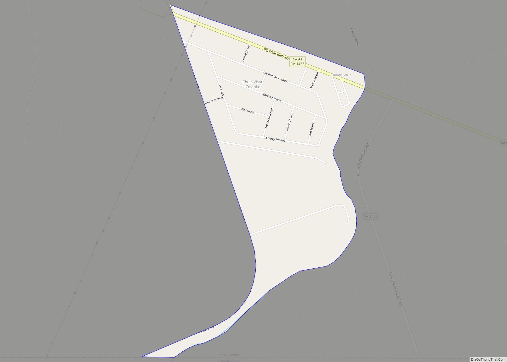
Chula Vista is a census-designated place (CDP) in Zavala County, Texas, United States. The population was 450 at the 2010 census. Prior to the 2010 census, the CDP was known as Chula Vista-River Spur. Chula Vista CDP overview: Name: Chula Vista CDP LSAD Code: 57 LSAD Description: CDP (suffix) State: Texas County: Zavala County Total ... Read more
Map of Chula Vista CDP, Texas
Map of Christoval CDP
Christoval is a census-designated place (CDP) in Tom Green County, Texas, United States. Its population was 504 at the 2010 census. It is part of the San Angelo, Texas, metropolitan statistical area. Christoval CDP overview: Name: Christoval CDP LSAD Code: 57 LSAD Description: CDP (suffix) State: Texas County: Tom Green County Elevation: 2,037 ft (621 m) Total ... Read more
Map of Christoval CDP
Map of Clarksville City
Clarksville City is a city in Gregg and Upshur counties in the U.S. state of Texas. The population was 780 at the 2020 census. Clarksville City city overview: Name: Clarksville City city LSAD Code: 25 LSAD Description: city (suffix) State: Texas County: Gregg County, Upshur County Elevation: 361 ft (110 m) Total Area: 6.53 sq mi (16.92 km²) Land Area: ... Read more
Map of Clarksville City
Map of Clarendon city, Texas
Clarendon is a city in Donley County, Texas, United States. Its population was 2,026 at the 2010 census. The county seat of Donley County, Clarendon is located on U.S. Highway 287 in the Texas Panhandle, 60 miles (97 km) east of Amarillo. Clarendon city overview: Name: Clarendon city LSAD Code: 25 LSAD Description: city (suffix) State: ... Read more
Map of Clarendon city, Texas
Map of Citrus City CDP
Citrus City is a census-designated place (CDP) in Hidalgo County, Texas. The population was 3,291 at the 2020 US Census. It is part of the McAllen–Edinburg–Mission Metropolitan Statistical Area. The town was founded in 1943 during World War II by Howard Moffitt, a builder known for his vernacular Moffitt cottage architectural style, as part of ... Read more
Map of Citrus City CDP
Map of Cisco city, Texas
Cisco is a city in Eastland County, Texas. The population was 3,899 at the time of the 2010 census. Cisco city overview: Name: Cisco city LSAD Code: 25 LSAD Description: city (suffix) State: Texas County: Eastland County Elevation: 1,634 ft (498 m) Total Area: 4.96 sq mi (12.84 km²) Land Area: 4.96 sq mi (12.83 km²) Water Area: 0.00 sq mi (0.01 km²) Total Population: 3,899 ... Read more
Map of Cisco city, Texas
Map of Circle D-KC Estates CDP
Circle D-KC Estates is a census-designated place (CDP) in Bastrop County, Texas, United States. The population was 2,588 at the 2020 census. Circle D-KC Estates CDP overview: Name: Circle D-KC Estates CDP LSAD Code: 57 LSAD Description: CDP (suffix) State: Texas County: Bastrop County Elevation: 502 ft (153 m) Total Area: 9.4 sq mi (24 km²) Land Area: 9.3 sq mi (24 km²) ... Read more
Map of Circle D-KC Estates CDP
Map of Cinco Ranch CDP
Cinco Ranch is a census-designated place and master-planned community located in the extraterritorial jurisdiction of the city of Houston within Fort Bend and Harris counties in the U.S. state of Texas. The population was 16,899 at the 2020 census. It lies about 25 miles (40 km) west of the Harris County seat of Houston and 10 ... Read more
Map of Cinco Ranch CDP
Map of Clyde city, Texas
Clyde is a city in Callahan County, Texas, United States. The population was 3,713 at the 2010 census, up from 3,345 at the 2000 census. It is part of the Abilene metropolitan statistical area. Clyde city overview: Name: Clyde city LSAD Code: 25 LSAD Description: city (suffix) State: Texas County: Callahan County Elevation: 2,001 ft (610 m) ... Read more
Map of Clyde city, Texas
Map of Clute city
Clute is a city in Brazoria County, Texas, within the Houston metropolitan area. As of the 2020 U.S. Census, the city population was 10,604. The city gained some fame with the discovery of a fossilized mammoth named Asiel. There is now a restaurant/museum of the same name to honor this discovery. Clute city overview: Name: ... Read more
Map of Clute city
Map of Cloverleaf CDP
Cloverleaf is a census-designated place (CDP) in east central Harris County, Texas, United States. The population was 24,100 at the 2020 census. Cloverleaf CDP overview: Name: Cloverleaf CDP LSAD Code: 57 LSAD Description: CDP (suffix) State: Texas County: Harris County Elevation: 26 ft (8 m) Total Area: 3.3 sq mi (8.6 km²) Land Area: 3.3 sq mi (8.6 km²) Water Area: 0.0 sq mi (0.0 km²) ... Read more
Map of Cloverleaf CDP
Map of Clint town
Clint is a town in El Paso County, Texas, United States. The population was 926 at the 2010 census. It is part of the El Paso Metropolitan Statistical Area. Clint town overview: Name: Clint town LSAD Code: 43 LSAD Description: town (suffix) State: Texas County: El Paso County Elevation: 3,638 ft (1,109 m) Total Area: 1.97 sq mi (5.11 km²) ... Read more
Map of Clint town