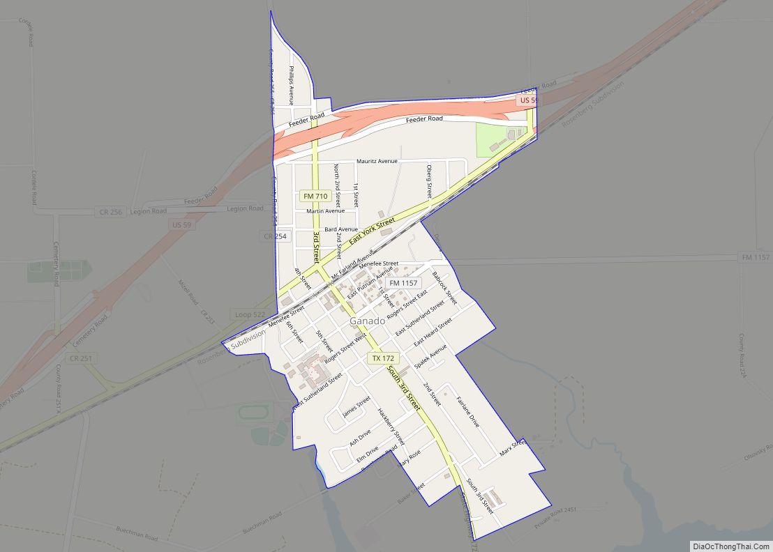
Map of Galveston city, Texas

Map of Galveston city, Texas

Galveston city overview: Name: Galveston city LSAD Code: 25 LSAD Description: city (suffix) State: Texas County: Galveston County Incorporated: town incorporated 1839 Elevation: 7 ft (2 m) Land Area: 41.05 sq mi (106.33 km²) Water Area: 170.66 sq mi (442.02 km²) Population Density: 1,307.9/sq mi (505.0/km²) Area code: 409 FIPS code: 4828068 GNISfeature ID: 1377745 Website: galvestontx.gov Online Interactive Map Galveston online map. Source: … Read more

Map of Gallatin city, Texas

Map of Gallatin city, Texas

Gallatin is a city in Cherokee County, Texas, in the United States, with a 2020 U.S. census-tabulated population of 321. Gallatin city overview: Name: Gallatin city LSAD Code: 25 LSAD Description: city (suffix) State: Texas County: Cherokee County Elevation: 404 ft (123 m) Total Area: 4.60 sq mi (11.92 km²) Land Area: 4.60 sq mi (11.92 km²) Water Area: 0.00 sq mi (0.00 km²) Total Population: … Read more

Map of Galena Park city

Map of Galena Park city

Galena Park is a city in Harris County, Texas, United States, within the Houston–Sugar Land–Baytown metropolitan area. The population was 10,740 at the 2020 census. Galena Park city overview: Name: Galena Park city LSAD Code: 25 LSAD Description: city (suffix) State: Texas County: Harris County Elevation: 7 ft (2 m) Total Area: 4.92 sq mi (12.74 km²) Land Area: 4.80 sq mi … Read more

Map of Garfield CDP, Texas

Map of Garfield CDP, Texas

Garfield is a census-designated place (CDP) in Travis County, Texas, in the United States. As of the 2010 census, the CDP population was 1,698. Garfield CDP overview: Name: Garfield CDP LSAD Code: 57 LSAD Description: CDP (suffix) State: Texas County: Travis County Elevation: 479 ft (146 m) Total Area: 12.2 sq mi (31.6 km²) Land Area: 12.0 sq mi (31.1 km²) Water Area: … Read more

Map of Giddings city

Map of Giddings city

Giddings is the county seat of Lee County, Texas, United States situated on the intersection of U.S. Highway 77 and U.S. Route 290. Its population was 4,969 at the 2020 census. Giddings city overview: Name: Giddings city LSAD Code: 25 LSAD Description: city (suffix) State: Texas County: Lee County Elevation: 505 ft (154 m) Total Area: 5.31 sq mi … Read more

Map of Gholson city

Map of Gholson city

Gholson is a city in McLennan County, Texas, United States. The population was 1,061 at the 2010 census. It is part of the Waco Metropolitan Statistical Area. The area was settled in the 1840s, and was early known as Sardis. The name Gholson, after early settlers, brothers Benjamin and Samuel Gholson, came into gradual use, … Read more

Map of Geronimo CDP, Texas

Map of Geronimo CDP, Texas

Geronimo is an unincorporated community and census-designated place (CDP) in Guadalupe County, Texas, United States. The population was 1,032 at the 2010 census, up from 619 at the 2000 census. It is part of the San Antonio Metropolitan Statistical Area. Geronimo CDP overview: Name: Geronimo CDP LSAD Code: 57 LSAD Description: CDP (suffix) State: Texas … Read more

Map of Georgetown city, Texas

Map of Georgetown city, Texas

Georgetown is a city in Texas and the county seat of Williamson County, Texas, United States. The population was 67,176 at the 2020 census. It is 30 miles (48 km) north of Austin. Founded in 1875 from four existing colleges, the oldest of which had been founded 35 years earlier, Southwestern University is the oldest university … Read more

Map of George West city

Map of George West city

George West is a city in Live Oak County, Texas, United States, and named for cattle rancher George Washington West. The population was 2,445 at the 2010 census. It is the county seat of Live Oak County. George West was named the “storytelling capital of Texas” in 2005 by the Texas Senate; and it hosts … Read more

Map of Gatesville city, Texas

Map of Gatesville city, Texas

Gatesville is a city in and the county seat of Coryell County, Texas, United States. Its population was 16,135 at the 2020 census. The city has five of the nine prisons and state jails for women operated by the Texas Department of Criminal Justice. One of the facilities, the Mountain View Unit, has the state’s … Read more

Map of Garza-Salinas II CDP

Map of Garza-Salinas II CDP

Garza-Salinas II is a census-designated place (CDP) in Starr County, Texas, United States. It is a new CDP formed from part of the La Puerta CDP prior to the 2010 census with a population of 719. Garza-Salinas II CDP overview: Name: Garza-Salinas II CDP LSAD Code: 57 LSAD Description: CDP (suffix) State: Texas County: Starr … Read more

Map of Gary City town

Map of Gary City town

Gary City is a town in Panola County, Texas, United States. The population was 311 at the 2010 census. Gary City town overview: Name: Gary City town LSAD Code: 43 LSAD Description: town (suffix) State: Texas County: Panola County Total Area: 1.90 sq mi (4.92 km²) Land Area: 1.90 sq mi (4.92 km²) Water Area: 0.00 sq mi (0.00 km²) Total Population: 311 Population … Read more