Map of Exmore town
Exmore is the largest town in Northampton County on the Eastern Shore of the U.S. state of Virginia. The population was 1,460 at the 2010 census. A popular story is that Exmore received its name because it is the tenth railroad station south of the Delaware state line, so there were “X more” stations to ... Read more
Map of Exmore town
Map of Ewing CDP, Virginia
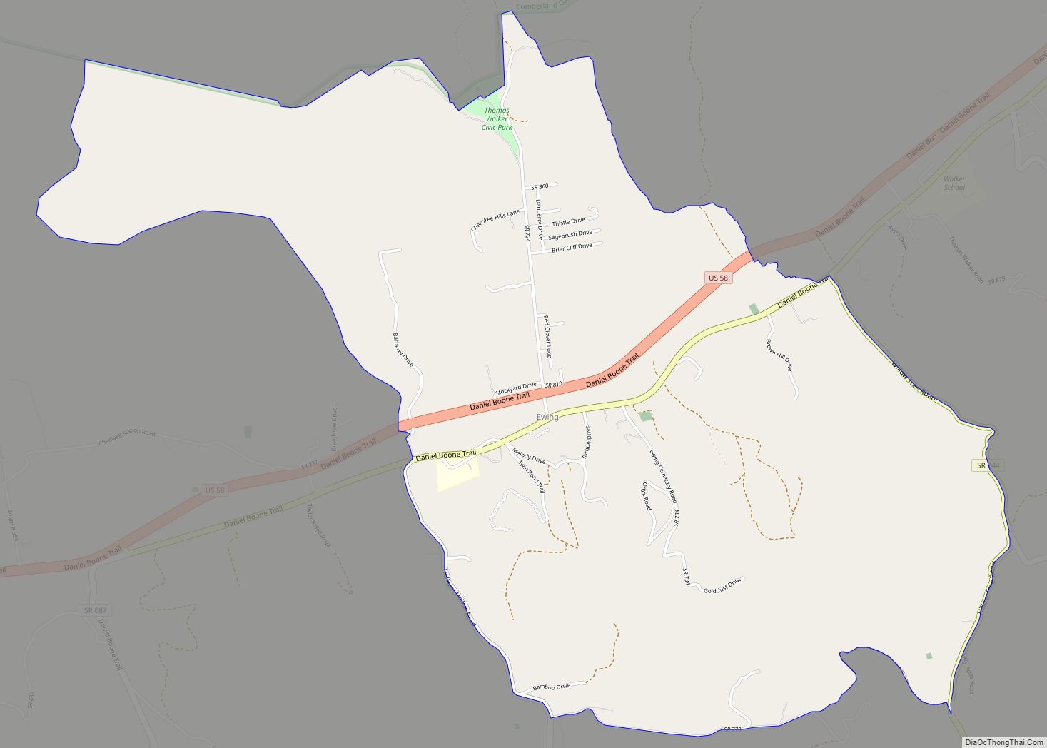
Ewing is an unincorporated community and census-designated place (CDP) in Lee County, Virginia. The population was 439 at the 2010 U.S. Census. Ewing is one of the westernmost settlements in the Commonwealth of Virginia, before reaching the Cumberland Gap and the borders with Kentucky and Tennessee. The Ewing post office was established in 1891. Ewing ... Read more
Map of Ewing CDP, Virginia
Map of Ettrick CDP, Virginia
Ettrick is a census-designated place (CDP) in Chesterfield County, Virginia, United States. Per the 2020 census, the population was 7,241. The town is home to Virginia State University and the Petersburg Amtrak train station. Most of Ettrick has a Petersburg mailing address, ZIP code 23803, although the community is not part of the city of ... Read more
Map of Ettrick CDP, Virginia
Map of Emory CDP, Virginia
Emory is a census-designated place (CDP) in Washington County, Virginia, United States. The population was 1,237 at the 2020 census down from 1,251 at the 2010 census. The community is named for and is the location of Emory and Henry College. It is part of the Kingsport–Bristol (TN)–Bristol (VA) Metropolitan Statistical Area, which is a ... Read more
Map of Emory CDP, Virginia
Map of Elliston CDP, Virginia
Elliston CDP overview: Name: Elliston CDP LSAD Code: 57 LSAD Description: CDP (suffix) State: Virginia County: Montgomery County FIPS code: 5125488 Online Interactive Map Elliston online map. Source: Basemap layers from Google Map, Open Street Map (OSM), Arcgisonline, Wmflabs. Boundary Data from Database of Global Administrative Areas. Elliston location map. Where is Elliston CDP? Elliston ... Read more
Map of Elliston CDP, Virginia
Map of Fincastle town, Virginia
Fincastle is a town in Botetourt County, Virginia, United States. The population was 755 at the 2020 census. It is the county seat of Botetourt County. Fincastle is part of the Roanoke Metropolitan Statistical Area. Fincastle town overview: Name: Fincastle town LSAD Code: 43 LSAD Description: town (suffix) State: Virginia County: Botetourt County Elevation: 1,240 ft ... Read more
Map of Fincastle town, Virginia
Map of Fieldale CDP
Fieldale is a census-designated place (CDP) in Henry County, Virginia, United States. The population was 879 at the 2010 census. It is part of the Martinsville Micropolitan Statistical Area. Fieldale CDP overview: Name: Fieldale CDP LSAD Code: 57 LSAD Description: CDP (suffix) State: Virginia County: Henry County Elevation: 810 ft (247 m) Total Area: 1.6 sq mi (4.2 km²) Land ... Read more
Map of Fieldale CDP
Map of Farmville town, Virginia
Farmville is a town in Prince Edward and Cumberland counties in the Commonwealth of Virginia. The population was 7,473 at the 2020 census. It is the county seat of Prince Edward County. Farmville developed near the headwaters of the Appomattox River in central Virginia; the waterway was long its main transportation access to other markets. ... Read more
Map of Farmville town, Virginia
Map of Fancy Gap CDP
Fancy Gap is a census-designated place (CDP) in Carroll County, Virginia. The population was 237 at the 2010 census. Fancy Gap CDP overview: Name: Fancy Gap CDP LSAD Code: 57 LSAD Description: CDP (suffix) State: Virginia County: Carroll County Elevation: 2,894 ft (882 m) Total Area: 4.0 sq mi (10.5 km²) Land Area: 4.0 sq mi (10.5 km²) Water Area: 0.0 sq mi (0.0 km²) Total ... Read more
Map of Fancy Gap CDP
Map of Falmouth CDP, Virginia
Falmouth is a census-designated place (CDP) in Stafford County, Virginia, United States. Situated on the north bank of the Rappahannock River at the falls, the community is north of and opposite the city of Fredericksburg. Recognized by the U.S. Census Bureau as a census-designated place (CDP), Falmouth’s population was 4,274 as of the 2010 census. ... Read more
Map of Falmouth CDP, Virginia
Map of Fairview CDP, Virginia
Fairview is a census-designated place in Mecklenburg County, Virginia, just north of Chase City.Some of the community is considered North Chase City. The population as of the 2010 census was 240. Fairview CDP overview: Name: Fairview CDP LSAD Code: 57 LSAD Description: CDP (suffix) State: Virginia County: Mecklenburg County ZIP code: 23924 FIPS code: 5126944 ... Read more
Map of Fairview CDP, Virginia
Map of Fairview Beach CDP
Fairview Beach is an unincorporated community and census-designated place (CDP) in King George County, Virginia, United States. The population was 391 at the 2010 census, which was up significantly from the 230 reported in 2000. Fairview Beach CDP overview: Name: Fairview Beach CDP LSAD Code: 57 LSAD Description: CDP (suffix) State: Virginia County: King George ... Read more
Map of Fairview Beach CDP