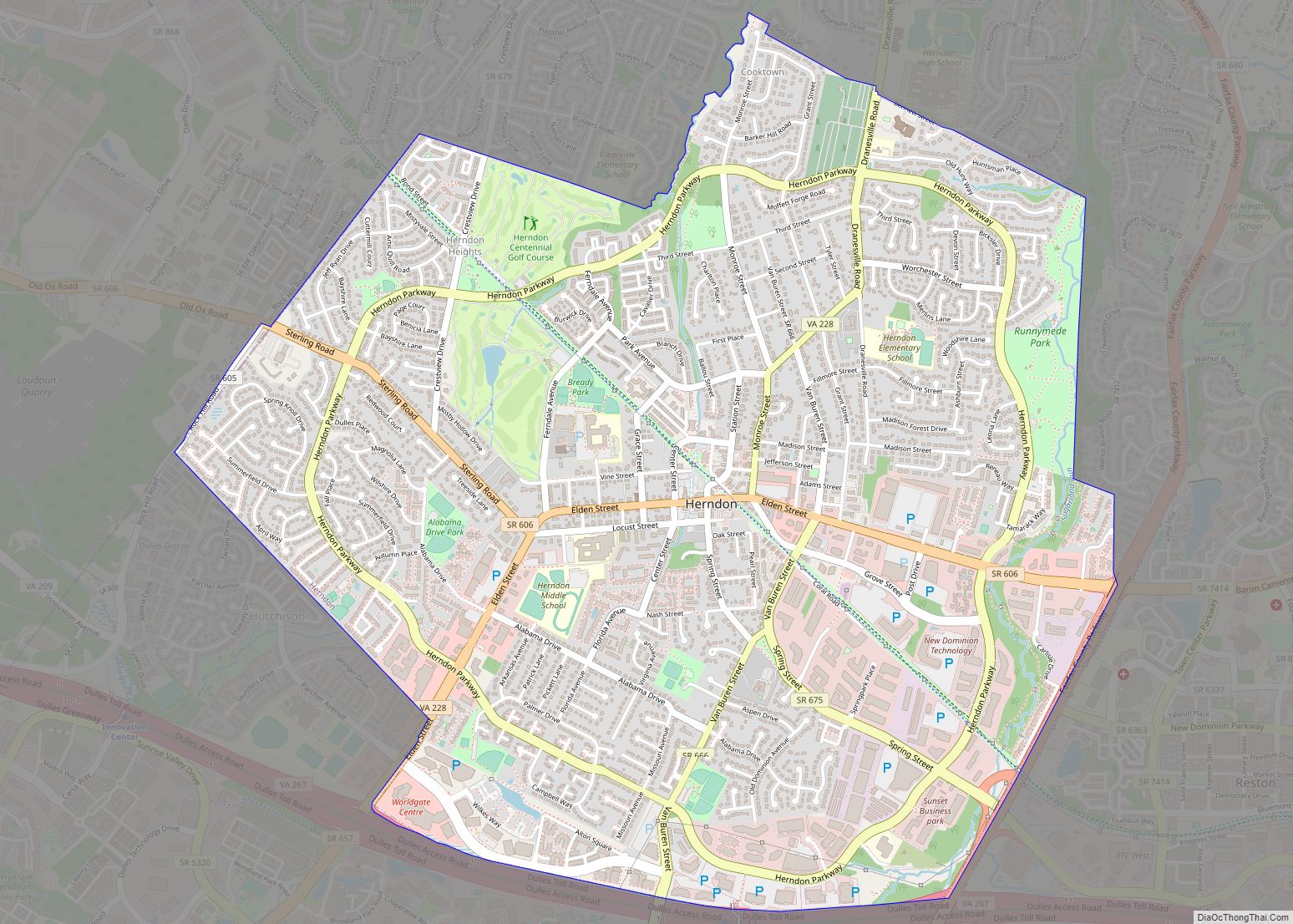
Map of Ettrick CDP

Map of Ettrick CDP, Virginia

Ettrick is a census-designated place (CDP) in Chesterfield County, Virginia, United States. Per the 2020 census, the population was 7,241. The town is home to Virginia State University and the Petersburg Amtrak train station. Most of Ettrick has a Petersburg mailing address, ZIP code 23803, although the community is not part of the city of … Read more

Map of Esmont CDP

Map of Esmont CDP

Esmont is a census-designated place (CDP) in Albemarle County, Virginia, United States. The population as of the 2020 Census was 491. Esmont, Guthrie Hall, and Mountain Grove are listed the National Register of Historic Places. Esmont CDP overview: Name: Esmont CDP LSAD Code: 57 LSAD Description: CDP (suffix) State: Virginia County: Albemarle County FIPS code: … Read more

Map of Enon CDP, Virginia

Map of Enon CDP, Virginia

Enon is a census-designated place (CDP) in Chesterfield County, Virginia, United States, just east of Chester. The population as of the 2010 Census was 3,466. It has the zip code 23836 and GPS coordinates 37.3504000, −77.3254000. Enon CDP overview: Name: Enon CDP LSAD Code: 57 LSAD Description: CDP (suffix) State: Virginia County: Chesterfield County FIPS … Read more

Map of Emory CDP, Virginia

Map of Emory CDP, Virginia

Emory is a census-designated place (CDP) in Washington County, Virginia, United States. The population was 1,237 at the 2020 census down from 1,251 at the 2010 census. The community is named for and is the location of Emory and Henry College. It is part of the Kingsport–Bristol (TN)–Bristol (VA) Metropolitan Statistical Area, which is a … Read more

Map of Ferrum CDP

Map of Ferrum CDP

Ferrum CDP overview: Name: Ferrum CDP LSAD Code: 57 LSAD Description: CDP (suffix) State: Virginia County: Franklin County FIPS code: 5127712 Online Interactive Map Ferrum online map. Source: Basemap layers from Google Map, Open Street Map (OSM), Arcgisonline, Wmflabs. Boundary Data from Database of Global Administrative Areas. Ferrum location map. Where is Ferrum CDP? Ferrum … Read more

Map of Farmville town, Virginia

Map of Farmville town, Virginia

Farmville is a town in Prince Edward and Cumberland counties in the Commonwealth of Virginia. The population was 7,473 at the 2020 census. It is the county seat of Prince Edward County. Farmville developed near the headwaters of the Appomattox River in central Virginia; the waterway was long its main transportation access to other markets. … Read more

Map of Fancy Gap CDP

Map of Fancy Gap CDP

Fancy Gap is a census-designated place (CDP) in Carroll County, Virginia. The population was 237 at the 2010 census. Fancy Gap CDP overview: Name: Fancy Gap CDP LSAD Code: 57 LSAD Description: CDP (suffix) State: Virginia County: Carroll County Elevation: 2,894 ft (882 m) Total Area: 4.0 sq mi (10.5 km²) Land Area: 4.0 sq mi (10.5 km²) Water Area: 0.0 sq mi (0.0 km²) Total … Read more

Map of Falmouth CDP, Virginia

Map of Falmouth CDP, Virginia

Falmouth is a census-designated place (CDP) in Stafford County, Virginia, United States. Situated on the north bank of the Rappahannock River at the falls, the community is north of and opposite the city of Fredericksburg. Recognized by the U.S. Census Bureau as a census-designated place (CDP), Falmouth’s population was 4,274 as of the 2010 census. … Read more

Map of Fairview CDP, Virginia

Map of Fairview CDP, Virginia

Fairview is a census-designated place in Mecklenburg County, Virginia, just north of Chase City.Some of the community is considered North Chase City. The population as of the 2010 census was 240. Fairview CDP overview: Name: Fairview CDP LSAD Code: 57 LSAD Description: CDP (suffix) State: Virginia County: Mecklenburg County ZIP code: 23924 FIPS code: 5126944 … Read more

Map of Fairview Beach CDP

Map of Fairview Beach CDP

Fairview Beach is an unincorporated community and census-designated place (CDP) in King George County, Virginia, United States. The population was 391 at the 2010 census, which was up significantly from the 230 reported in 2000. Fairview Beach CDP overview: Name: Fairview Beach CDP LSAD Code: 57 LSAD Description: CDP (suffix) State: Virginia County: King George … Read more

Map of Fairlawn CDP, Virginia

Map of Fairlawn CDP, Virginia

Fairlawn CDP overview: Name: Fairlawn CDP LSAD Code: 57 LSAD Description: CDP (suffix) State: Virginia County: Pulaski County FIPS code: 5126736 Online Interactive Map Fairlawn online map. Source: Basemap layers from Google Map, Open Street Map (OSM), Arcgisonline, Wmflabs. Boundary Data from Database of Global Administrative Areas. Fairlawn location map. Where is Fairlawn CDP? Fairlawn … Read more

Map of Fairfax Station CDP

Map of Fairfax Station CDP

Fairfax Station is a census-designated place (CDP) in Fairfax County, Virginia, United States. The population was 12,030 at the 2010 census. Located in Northern Virginia, its center is located 22 miles (35 km) southwest of Washington, D.C. Fairfax Station CDP overview: Name: Fairfax Station CDP LSAD Code: 57 LSAD Description: CDP (suffix) State: Virginia County: Fairfax … Read more