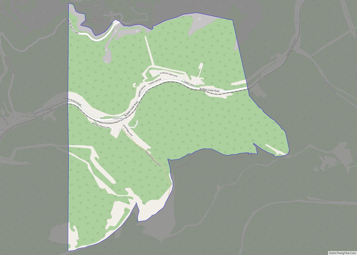
Salt Rock (also Saltrock) is a census-designated place (CDP) in southern Cabell County, West Virginia, United States. As of the 2010 census, its population was 388. It lies along West Virginia Route 10 southeast of the city of Huntington, the county seat of Cabell County. Its elevation is 581 feet (177 m). Although Salt Rock is unincorporated, ... Read more
West Virginia Cities and Places
Rowlesburg is a town in southern Preston County, West Virginia, United States, along the Cheat River. The population was 438 at the 2020 census. It is part of the Morgantown metropolitan area. A former railroad town, it is home to the Downtown Rowlesburg Historic District, and was the site of action during the American Civil ... Read more
Rossmore is an unincorporated community and census-designated place (CDP) in Logan County, West Virginia, United States, along West Virginia Route 44 and Island Creek. Its population was 301 as of the 2010 census. Rossmore CDP overview: Name: Rossmore CDP LSAD Code: 57 LSAD Description: CDP (suffix) State: West Virginia County: Logan County Elevation: 728 ft (222 m) ... Read more
Sissonville is a census-designated place (CDP) in Kanawha County, West Virginia, United States, along the Pocatalico River. The population was 4,028 at the 2010 census. Sissonville is located within 14 miles of Charleston, the state capital. Sissonville CDP overview: Name: Sissonville CDP LSAD Code: 57 LSAD Description: CDP (suffix) State: West Virginia County: Kanawha County ... Read more
Romney is a town in and the county seat of Hampshire County, West Virginia, United States. The population was 1,722 at the 2020 census. It is part of the Winchester, Virginia metropolitan area. Established in 1762 along with Shepherdstown, they are the oldest towns in West Virginia. Romney city overview: Name: Romney city LSAD Code: ... Read more
Stonewood is a city in Harrison County, West Virginia, United States. The population was 1,810 at the 2020 census. The name Stonewood has no special meaning, and was invented for the place. Stonewood city overview: Name: Stonewood city LSAD Code: 25 LSAD Description: city (suffix) State: West Virginia County: Harrison County Elevation: 1,037 ft (316 m) Total ... Read more
Stollings is an unincorporated community and census-designated place (CDP) in central Logan County, West Virginia, United States. As of the 2010 census, it had a population of 316. Stollings CDP overview: Name: Stollings CDP LSAD Code: 57 LSAD Description: CDP (suffix) State: West Virginia County: Logan County Elevation: 673 ft (205 m) Total Area: 0.384 sq mi (0.99 km²) Land ... Read more
Star City is a town in Monongalia County, West Virginia, United States. The population was 1,779 at the 2020 census. It is included in the Morgantown, West Virginia Metropolitan Statistical Area. Star City town overview: Name: Star City town LSAD Code: 43 LSAD Description: town (suffix) State: West Virginia County: Monongalia County Elevation: 955 ft (291 m) ... Read more
Stanaford is a census-designated place (CDP) and coal town in Raleigh County, West Virginia, United States. The population was 1,350 at the 2010 census. The community was named after nearby Stanaford Branch. Stanaford CDP overview: Name: Stanaford CDP LSAD Code: 57 LSAD Description: CDP (suffix) State: West Virginia County: Raleigh County Elevation: 2,402 ft (732 m) Total ... Read more
St. Marys is a city and the county seat of Pleasants County, West Virginia, United States. The population was 1,847 at the 2020 census. It is part of the Parkersburg–Vienna metropolitan area. St. Marys was established in 1849 by Alexander Creel, who is said to have had a vision of Mary while passing the townsite ... Read more
St. George CDP overview: Name: St. George CDP LSAD Code: 57 LSAD Description: CDP (suffix) State: West Virginia FIPS code: 5471284 Online Interactive Map St. George online map. Source: Basemap layers from Google Map, Open Street Map (OSM), Arcgisonline, Wmflabs. Boundary Data from Database of Global Administrative Areas. St. George location map. Where is St. ... Read more
St. Albans is a city in western Kanawha County, West Virginia, United States, at the confluence of the Kanawha and Coal rivers. The population was 10,861 at the 2020 census. It is part of the Charleston metropolitan area. St. Albans city overview: Name: St. Albans city LSAD Code: 25 LSAD Description: city (suffix) State: West ... Read more