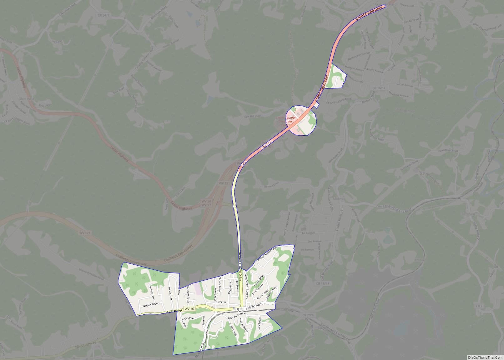
Map of Kincaid CDP, West Virginia

Map of Kincaid CDP, West Virginia

Kincaid is a census-designated place (CDP) in Fayette County, West Virginia, United States. As of the 2010 census, its population was 260. Kincaid is located on West Virginia Route 61,8 miles (13 km) northwest of Oak Hill. Kincaid has a post office with ZIP code 25119. The community was established in 1878. Kincaid CDP overview: Name: … Read more

Map of Kimberly CDP, West Virginia

Map of Kimberly CDP, West Virginia

Kimberly is a census-designated place (CDP) in Fayette County, West Virginia, United States. It is located along Armstrong Creek shortly before it enters the Kanawha River. As of the 2010 census, its population was 287. It is in zip code 25118. Kimberly CDP overview: Name: Kimberly CDP LSAD Code: 57 LSAD Description: CDP (suffix) State: … Read more

Map of Kimball town, West Virginia

Map of Kimball town, West Virginia

Kimball is a town in McDowell County, West Virginia, United States. Per the 2020 census, the population was 145. Kimball was incorporated in 1911 and named for Frederick J. Kimball, a railroad official. Kimball is the site of the first war memorial building erected in memory of the African-American veterans of World War I. Kimball … Read more

Map of Keystone city, West Virginia

Map of Keystone city, West Virginia

Keystone is a city in McDowell County, West Virginia, United States. Per the 2020 census, the population was 176. Keystone is one of the few municipalities in West Virginia with an African-American majority, with 65 percent of the residents being black. The term “Free State of McDowell” was coined by Matthew Thomas Whittico, a local … Read more

Map of Matoaka town

Map of Matoaka town

Matoaka is a census-designated place in Mercer County, West Virginia, United States. The population was 227 at the 2010 census. It is part of the Bluefield, WV-VA micropolitan area which has a population of 107,578. This town is named for Chief Powhatan’s daughter Matoaka who was better known by her nickname “Pocahontas”. Matoaka became an … Read more

Map of Lost Creek town, West Virginia

Map of Lost Creek town, West Virginia

Lost Creek is a town in Harrison County, West Virginia, United States. The population was 361 at the 2020 census. Lost Creek town overview: Name: Lost Creek town LSAD Code: 43 LSAD Description: town (suffix) State: West Virginia County: Harrison County Elevation: 1,020 ft (311 m) Total Area: 0.97 sq mi (2.51 km²) Land Area: 0.97 sq mi (2.51 km²) Water Area: 0.00 sq mi … Read more

Map of Matheny CDP, West Virginia

Map of Matheny CDP, West Virginia

Matheny is a census-designated place (CDP) in Wyoming County, West Virginia, United States. As of the 2010 census, its population was 531. The Laurel Fork flows through the community. Matheny CDP overview: Name: Matheny CDP LSAD Code: 57 LSAD Description: CDP (suffix) State: West Virginia County: Wyoming County Total Area: 3.525 sq mi (9.13 km²) Land Area: 3.501 sq mi … Read more

Map of Logan city, West Virginia

Map of Logan city, West Virginia

Logan is a city in Logan County, West Virginia, United States, along the Guyandotte River. The population was 1,438 at the 2020 census. It is the county seat of Logan County. Logan city overview: Name: Logan city LSAD Code: 25 LSAD Description: city (suffix) State: West Virginia County: Logan County Elevation: 679 ft (207 m) Total Area: … Read more

Map of Matewan town

Map of Matewan town

Matewan (/ˈmeɪtwɒn/) is a town in Mingo County, West Virginia, United States at the confluence of the Tug Fork River and Mate Creek. The population was 499 at the 2010 census. The Norfolk Southern Railway’s Pocahontas District passes through the town. It was a center of bitter labor coal mining labor conflict in the early … Read more

Map of Masontown town, West Virginia

Map of Masontown town, West Virginia

Masontown is a town in western Preston County, West Virginia, United States. The population was 510 at the 2020 census. It is part of the Morgantown metropolitan area. Masontown town overview: Name: Masontown town LSAD Code: 43 LSAD Description: town (suffix) State: West Virginia County: Preston County Elevation: 1,801 ft (549 m) Total Area: 0.28 sq mi (0.72 km²) Land … Read more

Map of Mason town, West Virginia

Map of Mason town, West Virginia

Mason, also known as Mason City, is a town in Mason County, West Virginia, United States. The population was 865 at the 2020 census. It is part of the Point Pleasant, WV–OH Micropolitan Statistical Area. Mason was initially known as Waggener’s Bottom. It was chartered by the Virginia General Assembly in 1856, and named for … Read more

Map of Martinsburg city, West Virginia

Map of Martinsburg city, West Virginia

Martinsburg is a city in and the county seat of Berkeley County, West Virginia, United States. The population was 18,773 at the 2020 census, making Martinsburg the largest city in the Eastern Panhandle of West Virginia and the seventh-largest city in the state. It is a principal city of the Hagerstown–Martinsburg metropolitan area extending into … Read more