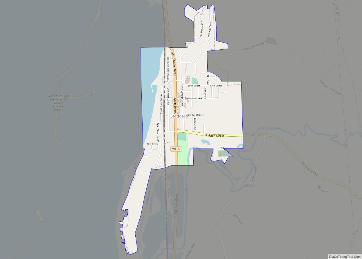
Map of Winchester CDP, Wisconsin

Map of Winchester CDP, Wisconsin

Winchester is an unincorporated census-designated place in the town of Winchester in Winnebago County, Wisconsin, United States. The community is located less than 1 mile (1 kilometer) from the southern intersection of U.S. Route 10 and U.S. Route 45. Wisconsin Highway 150 passed east–west through the community until the road was decommissioned by the state … Read more

Map of Woodville village, Wisconsin

Map of Woodville village, Wisconsin

Woodville is a village in St. Croix County, Wisconsin, United States. The population was 1,344 at the 2010 census. Woodville village overview: Name: Woodville village LSAD Code: 47 LSAD Description: village (suffix) State: Wisconsin County: St. Croix County Elevation: 1,142 ft (348 m) Total Area: 1.80 sq mi (4.65 km²) Land Area: 1.80 sq mi (4.65 km²) Water Area: 0.00 sq mi (0.00 km²) Total Population: … Read more

Map of Wilton village, Wisconsin

Map of Wilton village, Wisconsin

Wilton is a town in Monroe County, Wisconsin, United States. The population was 925 at the 2000 census. The Village of Wilton is located partially within the town. Wilton village overview: Name: Wilton village LSAD Code: 47 LSAD Description: village (suffix) State: Wisconsin County: Monroe County FIPS code: 5587525 Online Interactive Map Wilton online map. … Read more

Map of Woodruff CDP, Wisconsin

Map of Woodruff CDP, Wisconsin

Woodruff is a census-designated place in the Town of Woodruff in Oneida County, Wisconsin, United States. Woodruff CDP overview: Name: Woodruff CDP LSAD Code: 57 LSAD Description: CDP (suffix) State: Wisconsin County: Oneida County Elevation: 1,608 ft (490 m) Total Area: 1.434 sq mi (3.71 km²) Land Area: 1.409 sq mi (3.65 km²) Water Area: 0.025 sq mi (0.06 km²) Total Population: 966 Population Density: 670/sq mi … Read more

Map of Wilson village, Wisconsin

Map of Wilson village, Wisconsin

Wilson is a village in St. Croix County, Wisconsin, United States. The population was 184 at the 2010 census. Wilson village overview: Name: Wilson village LSAD Code: 47 LSAD Description: village (suffix) State: Wisconsin County: St. Croix County Total Area: 1.71 sq mi (4.42 km²) Land Area: 1.71 sq mi (4.42 km²) Water Area: 0.00 sq mi (0.00 km²) Total Population: 184 Population Density: … Read more

Map of Woodman village

Map of Woodman village

Woodman is a town in Grant County in the U.S. state of Wisconsin. The population was 195 at the 2000 census. The Village of Woodman is located within the town. Woodman village overview: Name: Woodman village LSAD Code: 47 LSAD Description: village (suffix) State: Wisconsin County: Grant County FIPS code: 5588825 Online Interactive Map Woodman … Read more

Map of Williams Bay village

Map of Williams Bay village

Williams Bay is a village in Walworth County, Wisconsin, United States. It is one of three municipalities on Geneva Lake. The population was 2,953 at the 2020 census. Williams Bay village overview: Name: Williams Bay village LSAD Code: 47 LSAD Description: village (suffix) State: Wisconsin County: Walworth County Elevation: 879 ft (268 m) Total Area: 2.78 sq mi (7.20 km²) … Read more

Map of Woodford CDP, Wisconsin

Map of Woodford CDP, Wisconsin

Woodford is an unincorporated community and census-designated place (CDP) in Lafayette County, Wisconsin, United States. Woodford is south of Argyle, in the town of Wiota. Woodford has a post office with ZIP code 53599. As of the 2010 census, its population is 69. Woodford CDP overview: Name: Woodford CDP LSAD Code: 57 LSAD Description: CDP … Read more

Map of Wonewoc village

Map of Wonewoc village

Wonewoc is a town in Juneau County, Wisconsin, United States. The population was 783 at the 2000 census. The Village of Wonewoc and the village of Union Center are located within the town. Wonewoc village overview: Name: Wonewoc village LSAD Code: 47 LSAD Description: village (suffix) State: Wisconsin County: Juneau County FIPS code: 5588500 Online … Read more

Map of Wittenberg village

Map of Wittenberg village

Wittenberg is a town in Shawano County, Wisconsin, United States. As of the 2000 census, the town had a total population of 894. The Village of Wittenberg is located within the town. The unincorporated community of Whitcomb is also located within the town. Wittenberg village overview: Name: Wittenberg village LSAD Code: 47 LSAD Description: village … Read more

Map of Withee village

Map of Withee village

Withee is a town in Clark County in the U.S. state of Wisconsin. The population was 885 at the 2000 census. The unincorporated community of Lombard is located in the town. Withee village overview: Name: Withee village LSAD Code: 47 LSAD Description: village (suffix) State: Wisconsin County: Clark County FIPS code: 5588275 Online Interactive Map … Read more

Map of Wisconsin Rapids city

Map of Wisconsin Rapids city

Wisconsin Rapids is a city in and the county seat of Wood County, Wisconsin, United States. The population was 18,877 at the 2020 census. The city also forms one of the core areas of the United States Census Bureau’s Marshfield-Wisconsin Rapids Micropolitan Statistical Area, which includes all of Wood County and had a 2020 population … Read more