Map of Elroy city, Wisconsin
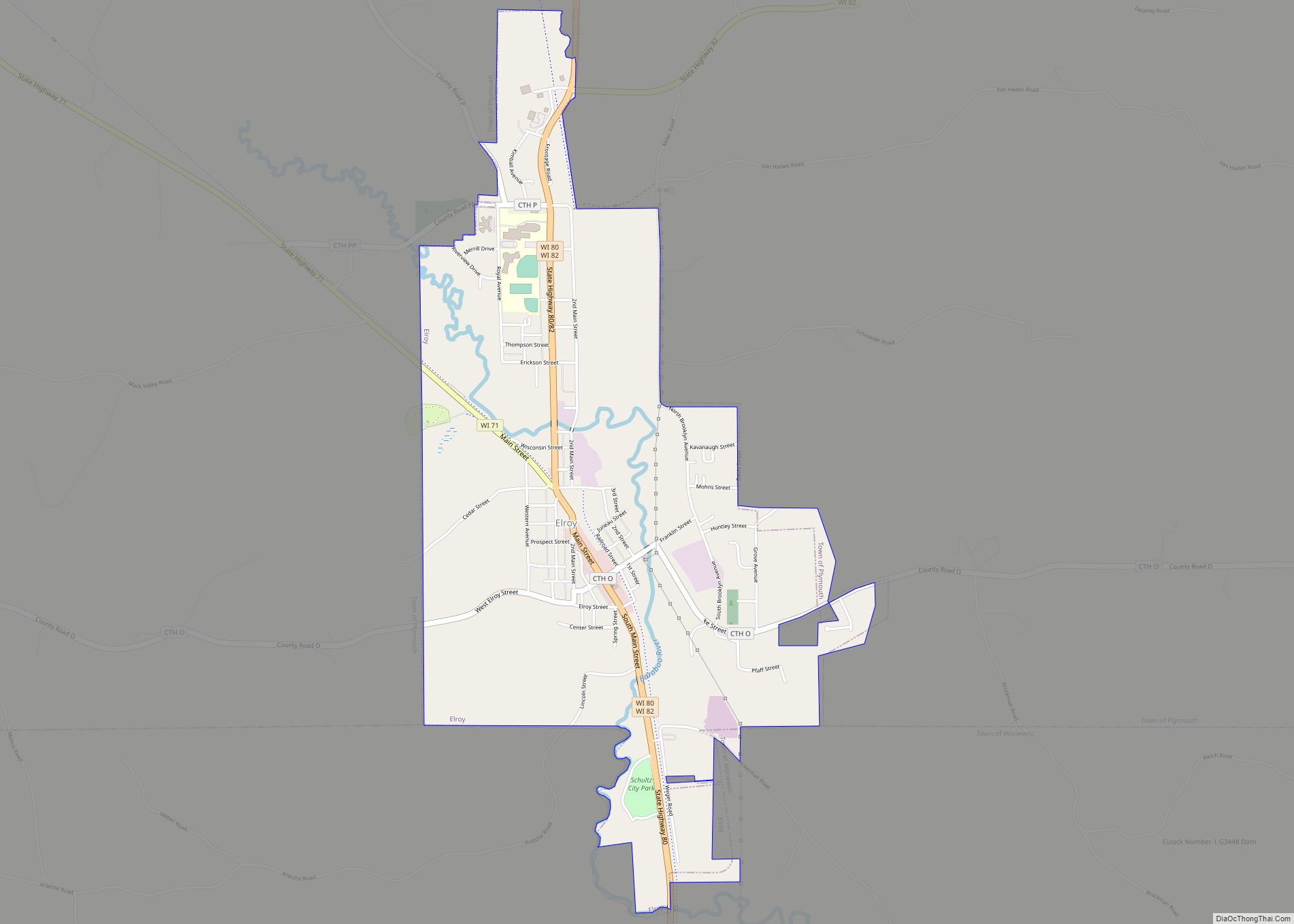
Elroy is a city in Juneau County, Wisconsin, United States, along the Baraboo River and at the east end of the Elroy-Sparta Bike Trail. The population was 1,442 at the 2010 census. Elroy city overview: Name: Elroy city LSAD Code: 25 LSAD Description: city (suffix) State: Wisconsin County: Juneau County Elevation: 978 ft (298 m) Total Area: ... Read more
Map of Elroy city, Wisconsin
Map of Fennimore city
Fennimore is a city in Grant County, Wisconsin, United States. The population was 2,497 at the 2010 census. The city’s area was separated from the Town of Fennimore, which remains as an adjacent rural area. Fennimore city overview: Name: Fennimore city LSAD Code: 25 LSAD Description: city (suffix) State: Wisconsin County: Grant County Elevation: 1,194 ft ... Read more
Map of Fennimore city
Map of Fall River village, Wisconsin
Fall River is a village in Columbia County, Wisconsin, United States, along the North Fork of the Crawfish River. The population was 1,712 at the 2010 census. It is part of the Madison Metropolitan Statistical Area. Fall River village overview: Name: Fall River village LSAD Code: 47 LSAD Description: village (suffix) State: Wisconsin County: Columbia ... Read more
Map of Fall River village, Wisconsin
Map of Fall Creek village
Fall Creek is a village in Eau Claire County, Wisconsin, United States. The population was 1,315 at the 2010 census. The village is bordered by the Town of Lincoln. Fall Creek village overview: Name: Fall Creek village LSAD Code: 47 LSAD Description: village (suffix) State: Wisconsin County: Eau Claire County Elevation: 938 ft (286 m) Total Area: ... Read more
Map of Fall Creek village
Map of Fairchild village
Fairchild is a town in Eau Claire County, Wisconsin, United States. The population was 351 at the 2000 census. The Village of Fairchild is located within the town. Fairchild village overview: Name: Fairchild village LSAD Code: 47 LSAD Description: village (suffix) State: Wisconsin County: Eau Claire County FIPS code: 5524825 Online Interactive Map Fairchild online ... Read more
Map of Fairchild village
Map of Fort Atkinson city, Wisconsin
Fort Atkinson is a city in Jefferson County, Wisconsin, United States. It is on the Rock River, a few miles upstream from Lake Koshkonong. The population was 12,579 at the 2020 census. Fort Atkinson is the largest city located entirely in Jefferson County, as Watertown is split between Jefferson and Dodge counties. Fort Atkinson is ... Read more
Map of Fort Atkinson city, Wisconsin
Map of Evansville city, Wisconsin
Evansville is a city in Rock County, Wisconsin, United States. The population was 5,703 at the 2020 census. Evansville is a part of the Janesville-Beloit Metropolitan Statistical Area and the Madison-Janesville-Beloit CSA. Evansville city overview: Name: Evansville city LSAD Code: 25 LSAD Description: city (suffix) State: Wisconsin County: Rock County Elevation: 912 ft (278 m) Total Area: ... Read more
Map of Evansville city, Wisconsin
Map of Forestville village, Wisconsin
Forestville is a village in Door County, Wisconsin, United States, along the Ahnapee River. The population was 430 at the 2010 census. The village is located within the Town of Forestville. The village uses the 54213 ZIP code. The Ahnapee State Trail passes through the village on the southwest. Forestville village overview: Name: Forestville village ... Read more
Map of Forestville village, Wisconsin
Map of Eureka CDP, Wisconsin
Eureka is an unincorporated census-designated place in the town of Rushford, in Winnebago County, Wisconsin, United States. It is located on the Fox River at the intersection of county highways K & E southwest of Omro. At the 2020 census, its population was 247. Eureka CDP overview: Name: Eureka CDP LSAD Code: 57 LSAD Description: ... Read more
Map of Eureka CDP, Wisconsin
Map of Forest Junction CDP
Forest Junction is an unincorporated census-designated place in the town of Brillion, Calumet County, Wisconsin, United States. As of the 2010 census, its population was 616. The community has its own water tower and utilities. Its ZIP code is 54123. Forest Junction CDP overview: Name: Forest Junction CDP LSAD Code: 57 LSAD Description: CDP (suffix) ... Read more
Map of Forest Junction CDP
Map of Footville village
Footville is a village in Rock County, Wisconsin, United States. The population was 772 at the 2020 census. Footville village overview: Name: Footville village LSAD Code: 47 LSAD Description: village (suffix) State: Wisconsin County: Rock County Elevation: 830 ft (253 m) Total Area: 1.12 sq mi (2.91 km²) Land Area: 1.12 sq mi (2.91 km²) Water Area: 0.00 sq mi (0.00 km²) Total Population: 772 Population ... Read more
Map of Footville village
Map of Florence CDP, Wisconsin
Florence is a census-designated place in and the county seat of Florence County, Wisconsin, United States. Florence is located in northern Florence County, in the town of Florence. Florence has a post office with ZIP code 54121. The community was named a census-designated place in 2010. As of the 2010 census, its population was 592. ... Read more
Map of Florence CDP, Wisconsin