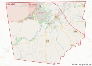
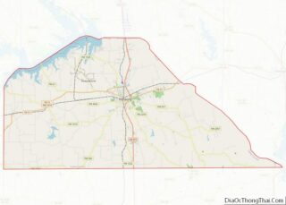
Map of Somerset County

Map of Somerset County, New Jersey

Somerset County overview: Name: Somerset County FIPS code: 34-035 State: New Jersey Founded: May 14, 1688 Named for: English county of Somerset Seat: Somerville Largest city: Franklin Township (population)Hillsborough Township (area) Total Area: 304.86 sq mi (789.6 km²) Land Area: 301.81 sq mi (781.7 km²) Total Population: 345,361 Population Density: 1,144.3/sq mi (441.8/km²) Website: www.co.somerset.nj.us Somerset County location map. Where is Somerset … Read more

Map of Hidalgo County

Map of Hidalgo County, New Mexico

Hidalgo County (Spanish: Condado de Hidalgo) is the southernmost county of the U.S. state of New Mexico. As of the 2010 census, the population was 4,894. The county seat and largest city is Lordsburg. A bill creating Hidalgo from the southern part of Grant County was passed on February 25, 1919, taking effect at the … Read more

Map of Socorro County

Map of Socorro County, New Mexico

Socorro County overview: Name: Socorro County FIPS code: 35-053 State: New Mexico Founded: January 9, 1852 Seat: Socorro Largest city: Socorro Total Area: 6,649 sq mi (17,220 km²) Land Area: 6,647 sq mi (17,220 km²) Total Population: 16,311 Population Density: 2.7/sq mi (1.0/km²) Time zone: UTC−7 (Mountain) Summer Time Zone (DST): UTC−6 (MDT) Website: www.socorrocounty.net Socorro County location map. Where is Socorro … Read more

Map of Cortland County

Map of Cortland County, New York

Cortland County is a county located in the U.S. state of New York. As of the 2020 census, the population of Cortland County was 46,809. The county seat is Cortland. The county is named after Pierre Van Cortlandt, president of the convention at Kingston that wrote the first New York State Constitution in 1777, and … Read more

Map of Madison County

Map of Madison County, New York

Madison County is a county located in the U.S. state of New York. As of the 2020 census, the population was 68,016. Its county seat is Wampsville. The county is named after James Madison, the fourth president of the United States, and was first formed in 1806. Madison County is part of the Syracuse metropolitan … Read more

Map of Richmond County

Map of Richmond County, New York

Staten Island (/ˈstætən/ STAT-ən) is a borough of New York City, coextensive with Richmond County, in the U.S. state of New York. Located in the city’s southwest portion, the borough is separated from New Jersey by the Arthur Kill and the Kill Van Kull and from the rest of New York by New York Bay. … Read more

Map of Wayne County

Map of Wayne County, New York

Wayne County is a county in the U.S. state of New York. As of the 2020 Census, the population was 91,283. The county seat is Lyons. The name honors General Anthony Wayne, an American Revolutionary War hero and American statesman. Wayne County is less than 50 miles west of, and is in the same Congressional … Read more

Map of Cabarrus County

Map of Cabarrus County, North Carolina

Cabarrus County (/kəˈbærəs/ kə-BARR-əs) is a county located in the south-central part of the U.S. state of North Carolina. As of the 2020 census, the population was 225,804. The county seat is Concord, which was incorporated in 1803. Cabarrus County is included in the Charlotte-Concord-Gastonia, NC-SC Metropolitan Statistical Area. The first substantiated gold find in … Read more

Map of Davidson County

Map of Davidson County, North Carolina

Davidson County is a county located in the U.S. state of North Carolina. As of the 2020 census, the population was 168,930. Its county seat is Lexington, and its largest city is Thomasville. Davidson County is included in the Winston-Salem, NC Metropolitan Statistical Area, which is also included in the Greensboro-Winston-Salem-High Point, NC Combined Statistical … Read more

Map of Henderson County

Map of Henderson County, North Carolina

Henderson County is a county located in the U.S. state of North Carolina. As of the 2020 census, the population was 116,281. Its county seat is Hendersonville. Henderson County is part of the Asheville Metropolitan Statistical Area. Henderson County overview: Name: Henderson County FIPS code: 37-089 State: North Carolina Founded: 1838 Named for: Leonard Henderson … Read more

Map of Mitchell County

Map of Mitchell County, North Carolina

Mitchell County is a county located in the U.S. state of North Carolina. As of the 2020 census, the population was 14,903. Its county seat is Bakersville. The county is home to the “Mineral City of the World”, Spruce Pine and Roan Mountain which includes the world’s largest natural rhododendron garden, and the longest stretch … Read more

Map of Richmond County

Map of Richmond County, North Carolina

Richmond County is a county located on the central southern border of the U.S. state of North Carolina. Its county seat is Rockingham. The county was formed in 1779 from a portion of Anson County and named in honor of Charles Lennox, 3rd Duke of Richmond and Lennox. As of the 2020 census, the population … Read more