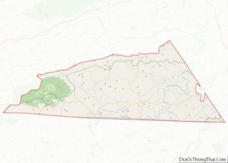
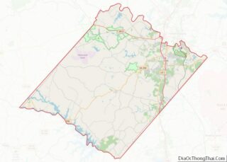
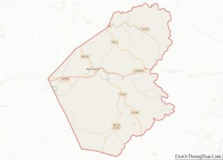
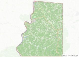
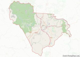
Map of Washington County

Map of Washington County, Kansas

Washington County (standard abbreviation: WS) is a county located in the U.S. state of Kansas. As of the 2020 census, the county population was 5,530. Its county seat and largest city is Washington. Washington County overview: Name: Washington County FIPS code: 20-201 State: Kansas Founded: February 20, 1857 Named for: George Washington Seat: Washington Largest … Read more

Map of Bracken County

Map of Bracken County, Kentucky

Bracken County is a county located in the U.S. state of Kentucky. As of the 2020 census, the population was 8,400. Its county seat is Brooksville. The county was formed in 1796. Bracken County is included in the Cincinnati-Middletown, OH-KY-IN Metropolitan Statistical Area. Bracken County overview: Name: Bracken County FIPS code: 21-023 State: Kentucky Founded: … Read more

Map of Crittenden County

Map of Crittenden County, Kentucky

Crittenden County is a county in the U.S. state of Kentucky. At the 2020 census, the population was 8,990. Its county seat is Marion. The county was formed in 1842 and named for John J. Crittenden, senator and future Governor of Kentucky. It is a prohibition or dry county. Crittenden County overview: Name: Crittenden County … Read more

Map of Green County

Map of Green County, Kentucky

Green County is a county located in the U.S. state of Kentucky. Its county seat and only municipality is Greensburg. Green was a prohibition or dry county until 2015. Green County overview: Name: Green County FIPS code: 21-087 State: Kentucky Founded: December 20, 1792 Named for: Nathanael Greene Seat: Greensburg Largest city: Greensburg Total Area: … Read more

Map of Knott County

Map of Knott County, Kentucky

Knott County is a county located in the U.S. state of Kentucky. As of the 2020 census, the population was 14,251. Its county seat is Hindman. The county was formed in 1884 and is named for James Proctor Knott, Governor of Kentucky (1883–1887). It is a prohibition or dry county. Its county seat is home … Read more

Map of Marshall County

Map of Marshall County, Kentucky

Marshall County is a county located in far western portion of the U.S. state of Kentucky. As of the 2020 census, the population was 31,659. Its county seat is Benton. It is the only Purchase Area county that does not border another state; a narrow strip of land in neighboring Livingston County separates Marshall County … Read more

Map of Ohio County

Map of Ohio County, Kentucky

Ohio County is a county located in the U.S. state of Kentucky. As of the 2020 census, the population was 23,772. Its county seat is Hartford, and its largest city is Beaver Dam. The county is named after the Ohio River, which originally formed its northern boundary. It is a moist county, which means that … Read more

Map of Spencer County

Map of Spencer County, Kentucky

Spencer County is a county located in the U.S. state of Kentucky. As of the 2020 census, the total population was 19,490. Its county seat is Taylorsville. The county was founded in 1824 and named for Spier Spencer. Spencer County is part of the Louisville/Jefferson County, KY—IN Metropolitan Statistical Area. Taylorsville Lake, located primarily within … Read more

Map of Assumption Parish

Map of Assumption Parish, Louisiana

Assumption Parish (French: Paroisse de l’Assomption, Spanish: Parroquia de la Asunción) is a parish located in the U.S. state of Louisiana. As of the 2020 census, the population was 21,039. Its parish seat is Napoleonville. Assumption Parish was established in 1807, as one of the original parishes of the Territory of Orleans. Assumption Parish is … Read more

Map of Evangeline Parish

Map of Evangeline Parish, Louisiana

Evangeline Parish (French: Paroisse d’Évangéline) is a parish located in the U.S. state of Louisiana. As of the 2020 census, the population was 32,350. The parish seat is Ville Platte. Evangeline Parish overview: Name: Evangeline Parish FIPS code: 22-039 State: Louisiana Founded: 1910 Named for: Acadian heroine of the poem “Evangeline” Seat: Ville Platte Largest … Read more

Map of Orleans Parish

Map of Orleans Parish, Louisiana

New Orleans (/ˈɔːrl(i)ənz/ OR-l(ee)ənz, /ɔːrˈliːnz/ or-LEENZ, locally /ˈɔːrlənz/ OR-lənz; French: La Nouvelle-Orléans [la nuvɛlɔʁleɑ̃] (listen), Spanish: Nueva Orleans) is a consolidated city-parish located along the Mississippi River in the southeastern region of the U.S. state of Louisiana. With a population of 383,997 according to the 2020 U.S. census, it is the most populous city in … Read more

Map of Saint Tammany Parish

Map of St. Tammany Parish, Louisiana

St. Tammany Parish overview: Name: St. Tammany Parish FIPS code: 22-103 State: Louisiana Founded: October 27, 1810 Named for: Indian Chief Tamanend Seat: Covington Largest city: Slidell Total Area: 1,124 sq mi (2,910 km²) Land Area: 846 sq mi (2,190 km²) Total Population: 264,570 Population Density: 312.73/sq mi (120.75/km²) Time zone: UTC−6 (Central) Summer Time Zone (DST): UTC−5 (CDT) Website: www.stpgov.org St. … Read more