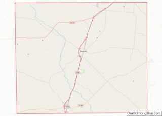
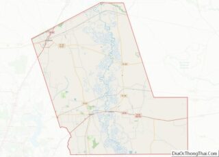
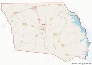
Map of Henry County, Ohio
Henry County is a county located in the U.S. state of Ohio. As of the 2020 census, the population was 27,662. Its county seat is Napoleon. The county was created in 1820 and later organized in 1834. It is named for American Founding Father Patrick Henry, the Virginian famous for his “give me liberty, or ... Read more
Map of Henry County, Ohio
Map of Mahoning County, Ohio
Mahoning County is a county in the U.S. state of Ohio. As of the 2020 census, the population was 228,614. Its county seat and largest city is Youngstown. The county is named after the Mahoning River and was formed on March 1, 1846; the 83rd county in Ohio. Until 1846, the area that is now ... Read more
Map of Mahoning County, Ohio
Map of Pike County, Ohio
Pike County is a county located in the Appalachian (southern) region of the U.S. state of Ohio. As of the 2020 census, the population was 27,088. Its county seat is Waverly. The county is named for explorer Zebulon Pike. Pike County overview: Name: Pike County FIPS code: 39-131 State: Ohio Founded: February 1, 1815 Named ... Read more
Map of Pike County, Ohio
Map of Vinton County, Ohio
Vinton County is a county located in the U.S. state of Ohio. As of the 2020 census, the population was 12,800, making it the least populous county in the state. Its county seat is McArthur. The county is named for Samuel Finley Vinton, US Representative from Ohio (1823–37, 1843–51). Vinton County overview: Name: Vinton County ... Read more
Map of Vinton County, Ohio
Map of Carter County, Oklahoma
Carter County is a county in the U.S. state of Oklahoma. As of the 2010 census, the population was 47,557. Its county seat is Ardmore. The county was named for Captain Ben W. Carter, a Cherokee who lived among the Chickasaw. Carter County is part of the Ardmore Micropolitan Statistical Area. It is also a ... Read more
Map of Carter County, Oklahoma
Map of Grady County, Oklahoma
Grady County is a county located in the U.S. state of Oklahoma. As of the 2010 census, the population was 52,431. Its county seat is Chickasha. It was named for Henry W. Grady, an editor of the Atlanta Constitution and southern orator. Grady County is part of the Oklahoma City, OK Metropolitan Statistical Area. Grady ... Read more
Map of Grady County, Oklahoma
Map of Logan County, Oklahoma
Logan County is a county located in the U.S. state of Oklahoma. As of the 2010 census, the population was 41,848. Its county seat is Guthrie. Logan County is part of the Oklahoma City, OK Metropolitan Statistical Area. Guthrie served as the capital of Oklahoma Territory from 1890 until 1907 and of the state of ... Read more
Map of Logan County, Oklahoma
Map of Ottawa County, Oklahoma
Ottawa County is a county located in the northeastern corner of the U.S. state of Oklahoma. As of the 2020 census, the population was 30,285. Its county seat is Miami. The county was named for the Ottawa Tribe of Oklahoma. It is also the location of the federally recognized Modoc Nation and the Quapaw Nation, ... Read more
Map of Ottawa County, Oklahoma
Map of Washington County, Oklahoma
Washington County is a county located in the northeastern part of the U.S. state of Oklahoma. As of the 2020 census, the population was 52,455. Its county seat is Bartlesville. Named for President George Washington, it is the second smallest county in Oklahoma in total area, adjacent to the largest county in Oklahoma, Osage County. ... Read more
Map of Washington County, Oklahoma
Map of Harney County, Oregon
Harney County overview: Name: Harney County FIPS code: 41-025 State: Oregon Founded: February 23, 1889 Named for: William S. Harney Seat: Burns Largest city: Burns Total Area: 10,226 sq mi (26,490 km²) Land Area: 10,133 sq mi (26,240 km²) Total Population: 7,495 Population Density: 0.7/sq mi (0.3/km²) Time zone: UTC−8 (Pacific) Summer Time Zone (DST): UTC−7 (PDT) Website: www.co.harney.or.us Harney County location ... Read more
Map of Harney County, Oregon
Map of Tillamook County, Oregon
Tillamook County overview: Name: Tillamook County FIPS code: 41-057 State: Oregon Founded: December 15, 1853 Named for: Tillamook people Seat: Tillamook Largest city: Tillamook Total Area: 1,333 sq mi (3,450 km²) Land Area: 1,103 sq mi (2,860 km²) Total Population: 27,390 Population Density: 23/sq mi (9/km²) Website: www.co.tillamook.or.us Tillamook County location map. Where is Tillamook County? History Tillamook County, the 12th county ... Read more
Map of Tillamook County, Oregon
Map of Bucks County, Pennsylvania
Bucks County overview: Name: Bucks County FIPS code: 42-017 State: Pennsylvania Founded: November 1682 Named for: Buckinghamshire Seat: Doylestown Largest town: Bensalem Total Area: 622 sq mi (1,610 km²) Land Area: 604 sq mi (1,560 km²) Total Population: 646,538 Population Density: 1,070/sq mi (410/km²) Time zone: UTC−5 (Eastern) Summer Time Zone (DST): UTC−4 (EDT) Website: www.buckscounty.gov Bucks County location map. Where is ... Read more
Map of Bucks County, Pennsylvania