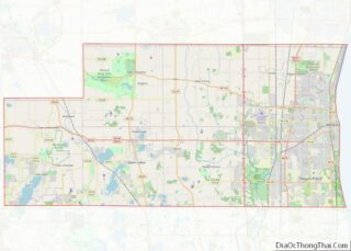
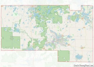
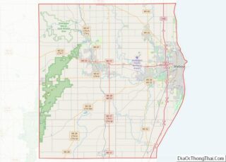
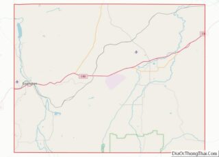
Map of Lamb County, Texas
Lamb County is a county located in the U.S. state of Texas. As of the 2020 census, its population was 13,045. Its county seat is Littlefield. The county was created in 1876, but not organized until 1908. It is named for George A. Lamb, who died in the Battle of San Jacinto. Lamb County was ... Read more
Map of Lamb County, Texas
Map of Mason County, Texas
Mason County is a rural county located on the Edwards Plateau in the U.S. state of Texas. At the 2020 census, its population was 3,953. Its county seat is Mason. The county is named for Fort Mason, which was located in the county. Mason County overview: Name: Mason County FIPS code: 48-319 State: Texas Founded: ... Read more
Map of Mason County, Texas
Map of Motley County, Texas
Motley County overview: Name: Motley County FIPS code: 48-345 State: Texas Founded: 1891 Seat: Matador Largest town: Matador Total Area: 990 sq mi (2,600 km²) Land Area: 990 sq mi (2,600 km²) Total Population: 1,063 Population Density: 1.1/sq mi (0.41/km²) Time zone: UTC−6 (Central) Summer Time Zone (DST): UTC−5 (CDT) Website: www.co.motley.tx.us Motley County location map. Where is Motley County? Motley County ... Read more
Map of Motley County, Texas
Map of Presidio County, Texas
Presidio County is a county located in the U.S. state of Texas. As of the 2020 census, its population was 6,131. Its county seat is Marfa. The county was created in 1850 and later organized in 1875. Presidio County (K-5 in Texas topological index of counties) is in the Trans-Pecos region of West Texas and ... Read more
Map of Presidio County, Texas
Map of San Saba County, Texas
San Saba County is a county located on the Edwards Plateau in western Central Texas, United States. As of the 2020 census, its population was 5,730. Its county seat is San Saba. The county is named after the San Saba River, which flows through the county. San Saba County overview: Name: San Saba County FIPS ... Read more
Map of San Saba County, Texas
Map of Terrell County, Texas
Terrell County is a county in the U.S. state of Texas. As of the 2020 census, its population was 760, making it the seventh-least populous county in Texas, and the 37th-least populous county in the nation. Its county seat is the census-designated place of Sanderson; no incorporated municipalities are in the county. The county was ... Read more
Map of Terrell County, Texas
Map of Ward County, Texas
Ward County is a county located in the U.S. state of Texas. As of the 2020 census, its population was 11,644. The county seat is Monahans. The county was created in 1887 and organized in 1892. It is named for Thomas W. Ward, a soldier in the Texas Revolution. Ward County overview: Name: Ward County ... Read more
Map of Ward County, Texas
Map of Zavala County, Texas
Zavala County overview: Name: Zavala County FIPS code: 48-507 State: Texas Founded: 1884 Named for: Lorenzo de Zavala Seat: Crystal City Largest city: Crystal City Total Area: 1,302 sq mi (3,370 km²) Land Area: 1,297 sq mi (3,360 km²) Total Population: 11,677 Population Density: 9.0/sq mi (3.5/km²) Time zone: UTC−6 (Central) Summer Time Zone (DST): UTC−5 (CDT) Website: www.co.zavala.tx.us Zavala County location ... Read more
Map of Zavala County, Texas
Map of Piute County, Utah
Piute County (/ˈpaɪjuːt/ PY-yoot) is a county in south-central Utah, United States. As of the 2010 United States Census, the population was 1,556, making it the second-least populous county in Utah. The county seat is Junction, and the largest town is Circleville. Piute County overview: Name: Piute County FIPS code: 49-031 State: Utah Founded: January ... Read more
Map of Piute County, Utah
Map of Caledonia County, Vermont
Caledonia County is a county located in the northeastern part of the U.S. state of Vermont. As of the 2020 census, the population was 30,233. Its shire town (county seat) is the town of St. Johnsbury. The county was created in 1792 and organized in 1796. It was given the Latin name for Scotland, in ... Read more
Map of Caledonia County, Vermont
Map of Amelia County, Virginia
Amelia County is a county located just southwest of Richmond in the Commonwealth of Virginia, United States. The county is located in Central Virginia and is included in the Greater Richmond Region. Its county seat is Amelia Court House. Amelia County was created in 1735 from parts of Prince George and Brunswick counties, and was ... Read more
Map of Amelia County, Virginia
Map of Caroline County, Virginia
Caroline County is a United States county located in the eastern part of the Commonwealth of Virginia. The northern boundary of the county borders on the Rappahannock River, notably at the historic town of Port Royal. The Caroline county seat is Bowling Green. Caroline County was established in 1728 and was named in honor of ... Read more
Map of Caroline County, Virginia