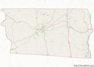
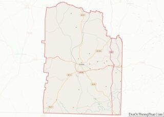
Map of Hamilton County

Map of Hamilton County, Florida

Hamilton County is a county located in the north central portion of the U.S. state of Florida. As of the 2020 census, the population was 14,004, down from 14,799 at the 2010 census. Its county seat is Jasper. Hamilton County overview: Name: Hamilton County FIPS code: 12-047 State: Florida Founded: December 26, 1827 Named for: … Read more

Map of Madison County

Map of Madison County, Florida

Madison County is a county located in the north central portion of the state of Florida, and borders the state of Georgia to the north. As of the 2020 census, the population was 17,968. Its county seat is also called Madison. Madison County overview: Name: Madison County FIPS code: 12-079 State: Florida Founded: December 26, … Read more

Map of Saint Johns County

Map of St. Johns County, Florida

St. Johns County is a county in the northeastern part of the U.S. state of Florida. As of the 2020 United States Census, its population was 273,425. The county seat and largest incorporated city is St. Augustine. St. Johns County is part of the Jacksonville metropolitan area. The county was established in 1821. It is … Read more

Map of Baker County

Map of Baker County, Georgia

Baker County is a county in Georgia. As of the 2020 census, the population was 2,876. The county seat and only city is Newton. The county was created December 12, 1825 from the eastern portion of Early County by an act of the Georgia General Assembly and is named for Colonel John Baker, a hero … Read more

Map of Camden County

Map of Camden County, Georgia

Camden County overview: Name: Camden County FIPS code: 13-039 State: Georgia Founded: 1777 Named for: Charles Pratt, 1st Earl Camden Seat: Woodbine Largest city: St. Marys Total Area: 782 sq mi (2,030 km²) Land Area: 613 sq mi (1,590 km²) Total Population: 54,768 Population Density: 89.3/sq mi (34.5/km²) Time zone: UTC−5 (Eastern) Summer Time Zone (DST): UTC−4 (EDT) Website: www.co.camden.ga.us Camden County … Read more

Map of Columbia County

Map of Columbia County, Georgia

Columbia County is a county located in the east central portion of the US state of Georgia. As of the 2020 census, the population was 124,035. The legal county seat is Appling, but the de facto seat of county government is Evans. Columbia County is included in the Augusta-Richmond County, GA-SC Metropolitan Statistical Area. It … Read more

Map of Elbert County

Map of Elbert County, Georgia

Elbert County is a county located in the northeastern part of the U.S. state of Georgia. As of the 2020 census, the population was 19,637. The county seat is Elberton. The county was established on December 10, 1790, and was named for Samuel Elbert. Elbert County overview: Name: Elbert County FIPS code: 13-105 State: Georgia … Read more

Map of Habersham County

Map of Habersham County, Georgia

Habersham County is a county located in the northeastern part of the U.S. state of Georgia. As of the 2020 census, the population was 46,031. The county seat is Clarkesville. The county was created on December 15, 1817, and named for Colonel Joseph Habersham of the Continental Army in the Revolutionary War. Habersham County comprises … Read more

Map of Jones County

Map of Jones County, Georgia

Jones County is a county in the central portion of the U.S. state of Georgia. As of the 2020 census, the population was 28,347. The county seat is Gray. The county was created on December 10, 1807, and named after U.S. Representative James Jones. Jones County overview: Name: Jones County FIPS code: 13-169 State: Georgia … Read more

Map of Miller County

Map of Miller County, Georgia

Miller County overview: Name: Miller County FIPS code: 13-201 State: Georgia Founded: 1856 Seat: Colquitt Largest city: Colquitt Total Area: 284 sq mi (740 km²) Land Area: 282 sq mi (730 km²) Total Population: 6,000 Population Density: 21/sq mi (8/km²) Time zone: UTC−5 (Eastern) Summer Time Zone (DST): UTC−4 (EDT) Website: www.millercountyga.gov Miller County location map. Where is Miller County? Miller County … Read more

Map of Pulaski County

Map of Pulaski County, Georgia

Pulaski County is a county located in the central portion of the U.S. state of Georgia. As of the 2020 census, the population was 9,855. The county seat is Hawkinsville. Pulaski County overview: Name: Pulaski County FIPS code: 13-235 State: Georgia Founded: 1808 Named for: Kazimierz Pułaski Seat: Hawkinsville Largest city: Hawkinsville Total Area: 251 sq mi … Read more

Map of Tattnall County

Map of Tattnall County, Georgia

Tattnall County is a county located in the southeast portion of the U.S. state of Georgia. As of the 2020 census, the population was 22,842. The county seat is Reidsville. Tattnall County was created on December 5, 1801, from part of Montgomery County, Georgia by the Georgia General Assembly. The county was named after Josiah … Read more