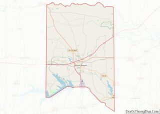
Map of Brewster County

Map of Brewster County, Texas

Brewster County is a county located in the U.S. state of Texas. It is in West Texas and its county seat (and only city) is Alpine. It is one of the nine counties that comprise the Trans-Pecos region, and borders Mexico. Brewster County is the largest county by area in the state – at 6,192 … Read more

Map of Childress County

Map of Childress County, Texas

Childress County (/ˈtʃɪldrɪs/ CHIL-driss) is a county located in the U.S. state of Texas. As of the 2020 census, its population was 6,664. The county seat is Childress. The county was created in 1876 and later organized in 1887. It is named for George Campbell Childress, the author of the Texas Declaration of Independence. County … Read more

Map of Crosby County

Map of Crosby County, Texas

Crosby County is a county located in the U.S. state of Texas. As of the 2020 census, its population was 5,133. The county seat is Crosbyton. The county was founded in 1876 and later organized in 1886. Both the county and its seat are named for Stephen Crosby, a land commissioner in Texas. Crosby County, … Read more

Map of El Paso County

Map of El Paso County, Texas

El Paso County is the westernmost county in the U.S. state of Texas. As of the 2020 census, the population was 865,657, making it the ninth-most populous county in the state of Texas. Its seat is the city of El Paso, the sixth-most populous city in Texas and the 22nd-most populous city in the United … Read more

Map of Gillespie County

Map of Gillespie County, Texas

Gillespie County is a county located on the Edwards Plateau in the U.S. state of Texas. As of the 2020 census, its population was 26,725. The county seat is Fredericksburg. It is located in the heart of the rural Texas Hill Country in Central Texas. Gillespie is named for Robert Addison Gillespie, a soldier in … Read more

Map of Harrison County

Map of Harrison County, Texas

Harrison County is a county on the eastern border of the U.S. state of Texas. As of the 2020 United States census, its population was 68,839. The county seat is Marshall. The county was created in 1839 and organized in 1842. It is named for Jonas Harrison, a lawyer and Texas revolutionary. Developed for cotton … Read more

Map of Irion County

Map of Irion County, Texas

Irion County (/ˈaɪriən/ EYE-ree-ən) is a county located on the Edwards Plateau in the U.S. state of Texas. As of the 2020 census, its population was 1,513. Its county seat is Mertzon. The county is named for Robert Anderson Irion, a secretary of state of the Republic of Texas. Irion County is included in the … Read more

Map of Kimble County

Map of Kimble County, Texas

Kimble County overview: Name: Kimble County FIPS code: 48-267 State: Texas Founded: 1876 Named for: George C. Kimble Seat: Junction Largest city: Junction Total Area: 1,251 sq mi (3,240 km²) Land Area: 1,251 sq mi (3,240 km²) Total Population: 4,286 Population Density: 3.4/sq mi (1.3/km²) Time zone: UTC−6 (Central) Summer Time Zone (DST): UTC−5 (CDT) Website: www.co.kimble.tx.us Kimble County location map. Where … Read more

Map of Llano County

Map of Llano County, Texas

Llano County (/ˈlænoʊ/) is a county located on the Edwards Plateau in the U.S. state of Texas. As of the 2020 census, its population was 21,243. Its county seat is Llano, and the county is named for the Llano River. During the American Civil War, the county was on the frontier, and Llano County’s soldiers … Read more

Map of Milam County

Map of Milam County, Texas

Milam County overview: Name: Milam County FIPS code: 48-331 State: Texas Founded: 1837 Named for: Benjamin Rush Milam Seat: Cameron Largest city: Rockdale Total Area: 1,022 sq mi (2,650 km²) Land Area: 1,017 sq mi (2,630 km²) Total Population: 24,754 Population Density: 24/sq mi (9.4/km²) Time zone: UTC−6 (Central) Summer Time Zone (DST): UTC−5 (CDT) Website: www.milamcounty.net Milam County location map. Where … Read more

Map of Palo Pinto County

Map of Palo Pinto County, Texas

Palo Pinto County is a county located in the U.S. state of Texas. As of the 2020 census, its population was 28,409. The county seat is Palo Pinto. The county was created in 1856 and organized the following year. Palo Pinto County comprises the Mineral Wells micropolitan statistical area, which is part of the Dallas–Fort … Read more

Map of Robertson County

Map of Robertson County, Texas

Robertson County overview: Name: Robertson County FIPS code: 48-395 State: Texas Founded: 1838 Named for: Sterling C. Robertson Seat: Franklin Largest city: Hearne Total Area: 865 sq mi (2,240 km²) Land Area: 856 sq mi (2,220 km²) Total Population: 16,757 Population Density: 19/sq mi (7.5/km²) Time zone: UTC−6 (Central) Summer Time Zone (DST): UTC−5 (CDT) Website: www.co.robertson.tx.us Robertson County location map. Where … Read more