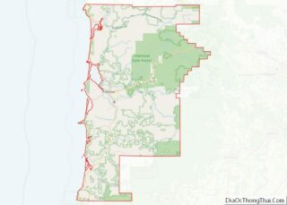
Map of Sharp County

Map of Sharp County, Arkansas

Sharp County is a county located in the U.S. state of Arkansas. As of the 2020 census, the population was 17,271. The county seat is Ash Flat. The county was formed on July 18, 1868, and named for Ephraim Sharp, a state legislator from the area. Sharp County overview: Name: Sharp County FIPS code: 05-135 … Read more

Map of El Dorado County

Map of El Dorado County, California

El Dorado County (/ˌɛl dəˈrɑːdoʊ/ (listen)), officially the County of El Dorado, is a county located in the U.S. state of California. As of the 2020 census, the population was 191,185. The county seat is Placerville. The County is part of the Sacramento–Roseville–Arden-Arcade, CA Metropolitan Statistical Area. It is located entirely in the Sierra Nevada, … Read more

Map of Modoc County

Map of Modoc County, California

Modoc County (/ˈmoʊdɒk/ (listen)) is a county in the far northeast corner of the U.S. state of California. Its population is 8,700 as of the 2020 census, down from 9,686 from the 2010 census. This makes it California’s third-least populous county. The county seat and only incorporated city is Alturas. Previous county seats include Lake … Read more

Map of San Mateo County

Map of San Mateo County, California

San Mateo County (/ˌsæn məˈteɪ.oʊ/ (listen) SAN mə-TAY-oh), officially the County of San Mateo, is a county located in the U.S. state of California. As of the 2020 census, the population was 764,442. Redwood City is the county seat, and the third most populated city following Daly City and San Mateo. San Mateo County is … Read more

Map of Yolo County

Map of Yolo County, California

Yolo County (/ˈjoʊloʊ/ (listen); Wintun: Yo-loy), officially the County of Yolo, is a county located in the northern portion of the U.S. state of California. As of the 2020 census, the population was 216,403. Its county seat is Woodland. Yolo County is included in the Greater Sacramento metropolitan area and is located in the Sacramento … Read more

Map of Custer County

Map of Custer County, Colorado

Custer County is a county located in the U.S. state of Colorado. As of the 2020 census, the population was 4,704. The county seat is Westcliffe. Custer County overview: Name: Custer County FIPS code: 08-027 State: Colorado Founded: March 9, 1877 Named for: George Armstrong Custer Seat: Westcliffe Largest town: Silver Cliff Total Area: 740 sq mi … Read more

Map of Jefferson County

Map of Jefferson County, Colorado

Jefferson County is a county located in the U.S. state of Colorado. As of the 2020 census, the population was 582,910, making it the fourth-most populous county in Colorado. The county seat is Golden, and the most populous city is Lakewood. Jefferson County is included in the Denver–Aurora-Lakewood, CO Metropolitan Statistical Area. Located along the … Read more

Map of Ouray County

Map of Ouray County, Colorado

Ouray County /ˈjʊəreɪ/ is a county located in the U.S. state of Colorado. As of the 2020 census, the population was 4,874. The county seat is Ouray. Because of its rugged mountain topography, Ouray County is also known as the Switzerland of America. Ouray County overview: Name: Ouray County FIPS code: 08-091 State: Colorado Founded: … Read more

Map of Weld County

Map of Weld County, Colorado

Weld County is a county located in the U.S. state of Colorado. As of the 2020 census, the population was 328,981. The county seat is Greeley. Weld County comprises the Greeley, CO Metropolitan Statistical Area, which is included in the Denver–Aurora, CO Combined Statistical Area. Weld County overview: Name: Weld County FIPS code: 08-123 State: … Read more

Map of Bay County

Map of Bay County, Florida

Bay County is a county on the Emerald Coast in Northwest Florida. As of the 2020 census, the population was 175,216. Its county seat is Panama City. Bay County is included in the Panama City, Florida Metropolitan Statistical Area. Bay County overview: Name: Bay County FIPS code: 12-005 State: Florida Founded: April 24, 1913 Named … Read more

Map of Gadsden County

Map of Gadsden County, Florida

Gadsden County is a county located in the panhandle of the U.S. state of Florida. As of the 2020 census, the population was 43,826. Its county seat is Quincy. Gadsden County is included in the Tallahassee, FL Metropolitan Statistical Area. Gadsden County is the only majority (over 50%) African-American county in Florida. Gadsden County overview: … Read more

Map of Lee County

Map of Lee County, Florida

Lee County is located in southwestern Florida on the Gulf Coast. As of the 2020 census, the population was 760,822. The county seat is Fort Myers (with a population of 86,395 as of the 2020 census), and the largest city is Cape Coral with an estimated 2020 population of 194,016. The county comprises the Cape … Read more