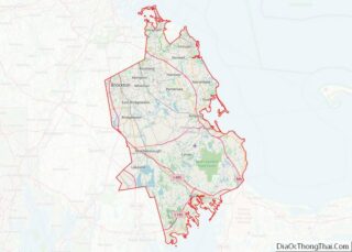
Map of Lyon County, Kentucky
Lyon County is a county located in the U.S. state of Kentucky. As of the 2020 census, the population was 8,680. Its county seat is Eddyville. The county was formed from Caldwell County, Kentucky in 1854 and named for former Congressman Chittenden Lyon. Lyon County overview: Name: Lyon County FIPS code: 21-143 State: Kentucky Founded: ... Read more
Map of Lyon County, Kentucky
Map of Morgan County, Kentucky
Morgan County is a county located in the U.S. state of Kentucky. As of the 2020 census, the population was 13,726. Its county seat is West Liberty. The county is among the dry counties, which means that the sale of alcohol is restricted or prohibited. Morgan County overview: Name: Morgan County FIPS code: 21-175 State: ... Read more
Map of Morgan County, Kentucky
Map of Russell County, Kentucky
Russell County is a county located in the U.S. Commonwealth of Kentucky. As of the 2020 census, the population was 17,991. Its county seat is Jamestown and its largest city is Russell Springs. The county was formed on December 14, 1825, from portions of Adair, Cumberland and Wayne Counties and is named for William Russell. ... Read more
Map of Russell County, Kentucky
Map of Woodford County, Kentucky
Woodford County is a county located in the U.S. state of Kentucky. As of the 2020 census, the population was 26,871. Its county seat is Versailles. The area was home to Pisgah Academy. Woodford County is part of the Lexington-Fayette, KY Metropolitan Statistical Area. It is located in the center of the Bluegrass region of ... Read more
Map of Woodford County, Kentucky
Map of De Soto Parish, Louisiana
DeSoto Parish (Spanish: Parroquia de DeSoto; French: Paroisse DeSoto) is a parish located in the U.S. state of Louisiana. The parish was formed in 1843. At the 2020 U.S. census, the population was 26,812. Its parish seat is Mansfield. DeSoto Parish is part of the Shreveport–Bossier City metropolitan statistical area. De Soto Parish overview: Name: ... Read more
Map of De Soto Parish, Louisiana
Map of Livingston Parish, Louisiana
Livingston Parish (Louisiana French: La Paroisse Livingston) is a parish in the U.S. state of Louisiana. Its parish seat is the town of Livingston. Livingston Parish is one of the Florida Parishes, a region which, unlike the rest of the state, was part of the Spanish Empire rather than the French Empire. The name Livingston ... Read more
Map of Livingston Parish, Louisiana
Map of St. John the Baptist Parish, Louisiana
St. John the Baptist Parish (SJBP, French: Paroisse de Saint-Jean-Baptiste) is a parish located in the U.S. state of Louisiana. At the 2020 census, the population was 42,477. The parish seat is Edgard, an unincorporated area, and the largest city is LaPlace, which is also unincorporated. St. John the Baptist Parish was established in 1807 ... Read more
Map of St. John the Baptist Parish, Louisiana
Map of Winn Parish, Louisiana
Winn Parish overview: Name: Winn Parish FIPS code: 22-127 State: Louisiana Founded: February 24, 1852 Named for: Walter Winn or Winfield Scott Seat: Winnfield Total Area: 2,480 km² (957 sq mi) Land Area: 2,500 km² (950 sq mi) Total Population: 13,755 Population Density: 5.5/km² (14/sq mi) Time zone: UTC-6 (CST) Summer Time Zone (DST): UTC-5 (CDT) Winn Parish location map. Where is ... Read more
Map of Winn Parish, Louisiana
Map of York County, Maine
York County is the southwesternmost county in the U.S. state of Maine, along the state of New Hampshire‘s eastern border. It is divided from Strafford County, New Hampshire, by the Salmon Falls River, and the connected tidal estuary—the Piscataqua River. York County was permanently established in 1639. It is the state’s oldest county and one ... Read more
Map of York County, Maine
Map of Prince George’s County, Maryland
Prince George’s County (often shortened to PG County) is a county located in the U.S. state of Maryland bordering the eastern portion of Washington, D.C. As of the 2020 U.S. census, the population was 967,201, making it the second-most populous county in Maryland, behind Montgomery County. The 2020 census counted an increase of nearly 104,000 ... Read more
Map of Prince George’s County, Maryland
Map of Middlesex County, Massachusetts
Middlesex County is located in the Commonwealth of Massachusetts, in the United States. As of the 2020 census, the population was 1,632,002, making it the most populous county in both Massachusetts and New England and the 22nd most populous county in the United States. Middlesex County is one of two U.S. counties (along with Santa ... Read more
Map of Middlesex County, Massachusetts
Map of Berrien County, Michigan
Berrien County is a county on the south line of Michigan, at the southwestern corner of the state. As of the 2020 Census, the population was 154,316. The county seat is St. Joseph. Berrien County is included in the Niles–Benton Harbor, MI Metropolitan Statistical Area, which is also included in the South Bend–Elkhart–Mishawaka, IN-MI Combined ... Read more
Map of Berrien County, Michigan